
Maine is a state in the New England region of the United States, and the northeasternmost state in the Lower 48. It borders New Hampshire to the west, the Gulf of Maine to the southeast, and the Canadian provinces of New Brunswick and Quebec to the northeast and northwest, and shares a maritime border with Nova Scotia. Maine is the largest state in New England by total area, nearly larger than the combined area of the remaining five states. Of the 50 U.S. states, it is the 12th-smallest by area, the 9th-least populous, the 13th-least densely populated, and the most rural. Maine's capital is Augusta, and its most populous city is Portland, with a total population of 68,408, as of the 2020 census.

Aroostook County is a county in the U.S. state of Maine along the Canada–United States border. As of the 2020 census, the population was 67,105. The county seat is Houlton, with offices in Caribou and Fort Kent.
Charlotte County is the most southwestern county of New Brunswick, Canada.

The Aroostook War, or the Madawaska War, was a military and civilian-involved confrontation in 1838–1839 between the United States and the United Kingdom over the international boundary between the British colony of New Brunswick and the U.S. state of Maine. The term "war" was rhetorical; local militia units were called out but never engaged in actual combat. The event is best described as an international incident.
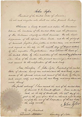
The Webster–Ashburton Treaty, signed August 9, 1842, was a treaty that resolved several border issues between the United States and the British North American colonies. Signed under John Tyler's presidency, it resolved the so-called Aroostook War. The provisions of the treaty included:

Campobello Island is the largest and only inhabited island in Campobello, a geographic parish in southwestern New Brunswick, Canada, near the border with Maine, United States. The island's permanent population in 2021 was 949. It is the site of the Roosevelt Campobello International Park, Head Harbour Lighthouse, and of Herring Cove Provincial Park.

The St. Croix River is a river in northeastern North America, 71 miles (114 km) in length, that forms part of the Canada–United States border between Maine (U.S.) and New Brunswick (Canada). The river rises in the Chiputneticook Lakes and flows south and southeast, between Calais and St. Stephen. It discharges into Passamaquoddy Bay, in the Bay of Fundy.

The Saint John River is a 673-kilometre-long (418 mi) river flowing within the Dawnland region from headwaters in the Notre Dame Mountains near the Maine-Quebec border through western New Brunswick to the northwest shore of the Bay of Fundy. Eastern Canada's longest river, its drainage basin is one of the largest on the east coast at about 55,000 square kilometres (21,000 sq mi). This “River of the Good Wave” and its tributary drainage basin formed the territorial countries of the Wolastoqiyik and Passamaquoddy First Nations prior to European colonization, and it remains a cultural centre of the Wabanaki Confederacy to this day.

The Canada–United States border is the longest international border in the world. The boundary is 8,891 km (5,525 mi) long. The land border has two sections: Canada's border with the contiguous United States to its south, and with the U.S. state of Alaska to its west. The bi-national International Boundary Commission deals with matters relating to marking and maintaining the boundary, and the International Joint Commission deals with issues concerning boundary waters. The agencies responsible for facilitating legal passage through the international boundary are the Canada Border Services Agency (CBSA) and U.S. Customs and Border Protection (CBP).

Machias Seal Island is an island in disputed water between the Gulf of Maine and the Bay of Fundy, about 16 km (10 mi) southeast from Cutler, Maine, and 19 km (12 mi) southwest of Grand Manan Island, New Brunswick. Sovereignty of the island is disputed by the United States and Canada. The Canadian Coast Guard continues to staff a lighthouse on the island; the first lighthouse was constructed there in 1832.

The Gulf of Maine is a large gulf of the Atlantic Ocean on the east coast of North America. It is bounded by Cape Cod at the eastern tip of Massachusetts in the southwest and by Cape Sable Island at the southern tip of Nova Scotia in the northeast. The gulf includes the entire coastlines of the U.S. states of New Hampshire and Maine, as well as Massachusetts north of Cape Cod, and the southern and western coastlines of the Canadian provinces of New Brunswick and Nova Scotia, respectively.

Passamaquoddy Bay is an inlet of the Bay of Fundy, between the U.S. state of Maine and the Canadian province of New Brunswick, at the mouth of the St. Croix River. Most of the bay lies within Canada, with its western shore bounded by Washington County, Maine. The southernmost point is formed by West Quoddy Head on the U.S. mainland in Lubec, Maine; and runs northeasterly through Campobello Island, New Brunswick, engulfing Deer Island, New Brunswick, to the New Brunswick mainland head at L'Etete, New Brunswick in Charlotte County, New Brunswick.
The Republic of Madawaska was a putative republic in the northwest corner of Madawaska County, New Brunswick and adjacent areas of Aroostook County in the US state of Maine and of Quebec.
The European and North American Railway (E&NA) is the name for three historic Canadian and American railways which were built in New Brunswick and Maine.

The Atlantic Northeast is a geographic and cultural region of eastern North America bounded by the Atlantic Ocean to the east and (loosely) by the Saint Lawrence River to the northwest. Though no official boundary exists, the most common conception includes the Maritime provinces, southern Quebec, and the island of Newfoundland in Canada, and the New England region of the United States. Broader conceptions reach further north into Canada, including Labrador and the Côte-Nord region of Quebec. Narrower conceptions may be limited to the coastal areas east of the Appalachian Mountains. The variety of definitions can be attributed to overlapping commonalities of the region's history, culture, geography, ecology, society, and other factors.

The history of post-confederation Canada began on July 1, 1867, when the British North American colonies of Canada, New Brunswick, and Nova Scotia were united to form a single Dominion within the British Empire. Upon Confederation, the United Province of Canada was immediately split into the provinces of Ontario and Quebec. The colonies of Prince Edward Island and British Columbia joined shortly after, and Canada acquired the vast expanse of the continent controlled by the Hudson's Bay Company, which was eventually divided into new territories and provinces. Canada evolved into a fully sovereign state by 1982.
The United States has land borders with only Canada and Mexico, both of them long. It has maritime boundaries with many countries due to its extensive exclusive economic zone (EEZ). All of its maritime borders with Canada are at least partially disputed, and its territorial claims on three Caribbean islands are disputed.

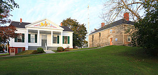
Fort Kent, located at the confluence of the Fish and Saint John rivers in the town of Fort Kent, Maine, United States, is the only surviving American fortification built during the border tensions with neighboring New Brunswick known as the Aroostook War. It is preserved as the Fort Kent State Historic Site, which features an original log blockhouse that is open for visits in the summer. The fort was added to the National Register of Historic Places in 1969 and declared a National Historic Landmark in 1973.

