
Burland is a village and civil parish in the unitary authority of Cheshire East and the ceremonial county of Cheshire, England, about 2½ miles west of Nantwich. The civil parish also includes the small settlements of Burland Lower Green, Burland Upper Green, Hollin Green and Stoneley Green, as well as parts of Gradeley Green and Swanley. The eastern part of the village of Ravensmoor also falls within the civil parish.
The River Croco is a small river in Cheshire in England. It starts as lowland field drainage west of Congleton, flows along the south edge of Holmes Chapel, and joins the River Dane at Middlewich. It is about 8 miles (13 km) long.

The River Roddlesworth is a river in Lancashire, England, a tributary of the River Darwen.

Handforth is a town between Wilmslow, Heald Green and Styal in Cheshire, England. The population of the civil parish as of the 2011 census was 6,266. In the 1960s and 1970s, two overspill housing estates, Spath Lane in Handforth and Colshaw Farm nearby in Wilmslow, were built to re-house people from inner city Manchester.

Norbury is a hamlet and civil parish in the unitary authority of Cheshire East and the ceremonial county of Cheshire, England. The parish lies on the boundary with Cheshire West and Chester, and also includes the small settlements of Gauntons Bank, Hurst Green, Swanwick Green, Norbury Common and Holtridge, with a total population of nearly 200 people in 2011. The hamlet of Norbury lies around 5 miles (8 km) north of Whitchurch in Shropshire. Nearby villages include No Man's Heath, Marbury and Wrenbury.

Bradwall is a small village and civil parish in the unitary authority of Cheshire East, about 2 mi (3.2 km) northwest of Sandbach in the ceremonial county of Cheshire, England, and about 20 mi (32 km) south of Manchester. According to the 2011 census, the population of the entire parish was 182. The area is predominantly agricultural, with no manufacturing or retail outlets.

Brereton is a civil parish in the unitary authority of Cheshire East and the ceremonial county of Cheshire, England. According to the 2001 census, the population of the entire civil parish was 1,012, increasing to 1,190 at the 2011 Census. Brereton is mentioned in the Domesday book as the Manor of Bretune. The civil parish includes the hamlets of Brereton Green, Brereton Heath, Smethwick Green, Medhurst Green, Sandlow Green and Davenport. It takes its name from Britonnic bre meaning a hill and reton meaning fern or ferns, thus "Fernhill".

Hatherton is a hamlet and civil parish in the unitary authority of Cheshire East and the ceremonial county of Cheshire, England. The hamlet is located on the B5071 at SJ687474, 2 3⁄4 miles (4.4 km) to the north east of Audlem and 3 3⁄4 miles (6.0 km) to the south east of Nantwich. The civil parish has an area of 673 hectares and also includes the small settlements of Birchall Moss, Broomlands and part of Artlebrook, with a total population of 360 in 2011. Nearby villages include Hankelow, Stapeley, Walgherton, Wybunbury, Blakenhall and Buerton. The A529 runs through the parish and the River Weaver forms the western boundary.

Minshull Vernon is a hamlet and civil parish in the unitary authority of Cheshire East and the ceremonial county of Cheshire, England. The hamlet lies 3 miles (5 km) to the north west of Crewe, south east of Winsford and south west of Middlewich. The parish also includes the small settlements of Bradfield Green, Eardswick, Hoolgrave, Minshull Hill, Walley's Green and Weaver Bank. The total population of the civil parish is somewhat over 200, measured at 391 in the Census 2011. Nearby villages include Church Minshull, Warmingham and Wimboldsley.

St Oswald's Church is north of the village of Brereton Green, adjacent to Brereton Hall, in the civil parish of Brereton, Cheshire, England, on the banks of the River Croco. It is recorded in the National Heritage List for England as a designated Grade II* listed building, and is described as "an unusually complete late Perpendicular church". It is an active Anglican parish church in the diocese of Chester, the archdeaconry of Macclesfield and the deanery of Congleton. Its benefice is combined with those of Christ Church, Eaton, and St Michael, Hulme Walfield.
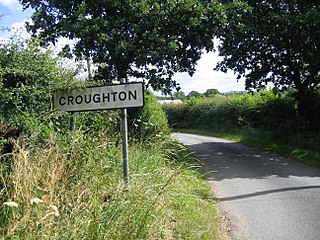
Croughton is a hamlet and civil parish on the outskirts and 3.5 miles (5.7 km) north of the city of Chester, and part of the unitary authority of Cheshire West and Chester and the ceremonial county of Cheshire. The Shropshire Union Canal runs through Croughton.

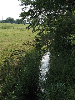
Swanley is a hamlet at SJ618523 in the unitary authority of Cheshire East and the ceremonial county of Cheshire, England. It mainly falls within the civil parish of Burland, with a part in Baddiley. Swanley lies around 2 1⁄2 miles (4.0 km) to the west of Nantwich and immediately north of the hamlet of Stoneley Green. Nearby villages include Burland, Acton and Ravensmoor. A dry moated site is located near the 16th-century Swanley Hall, and there are two 17th-century buildings. The Llangollen Canal runs through the hamlet, with two locks, two bridges and a marina.

Brereton Hall is a country house to the north of the village of Brereton Green, adjacent to St Oswald's Church, in the civil parish of Brereton, Cheshire, England. It is recorded in the National Heritage List for England as a designated Grade I listed building.
Smethwick Green is a hamlet near Congleton in Cheshire in England. Until 2009 it formed part of the Brereton Ward of Congleton District Council but, on the creation Cheshire East Unitary Authority, it became part of the Congleton Rural Ward.

The A535 road is a non-primary route in England that runs from Holmes Chapel, Cheshire to Alderley Edge, Cheshire. It passes through the Dane River valley. It is the main road that gives access to the Jodrell Bank Observatory and the Quinta Arboretum, planted by Sir Bernard Lovell in 1948.
Bradley Green is a hamlet in Cheshire West and Chester, England. It lies about 1 1⁄2 miles (2.4 km) southeast of the town of Malpas and falls within the civil parish of Tushingham-cum-Grindley, Macefen and Bradley.

Helsby hill fort is an Iron Age hillfort overlooking the village of Helsby in Cheshire, northwest England. Helsby Hill has steep cliffs on the northern and western sides, providing a natural semicircular defence. Double rampart earthworks extend to the south and east to provide protection to those flanks. Two additional banks have been discovered enclosing a rock ledge on the cliff to the north side. Excavations last century revealed a wall composed of sand and rubble, revetted with stone to the back and front. The hill has a summit of 141 m AOD, and is a prominent landmark rising above the Cheshire Plain, with fine views overlooking the Mersey Estuary and into Wales. Much of the hill is owned and managed by the National Trust. The surrounding areas are well wooded to the southwest, northwest and northeast with farmland to the southeast. The hill fort is protected as a Scheduled Ancient Monument.

Holdworth is a small rural hamlet situated within the boundary of the City of Sheffield, England. It is located 4.7 miles (7.5 km) northwest of the city centre at an altitude of 280 metres above sea level, giving it extensive views south over the upper Loxley valley. The hamlet falls within the Stannington ward of the City. It is an ancient farming settlement which was mentioned in the Domesday Book of 1086.

Leekfrith is a civil parish in the Staffordshire Moorlands, in Staffordshire, England, north of the town of Leek. The population of the civil parish at the 2011 census was 363.
