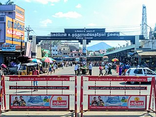
Puthunagaram is a town and gram panchayat in the Palakkad district, state of Kerala, India.
B. Meenakshipuram is a panchayat town in Bodinayakanur Taluk, Theni district Located in Madurai Region in The state of Tamil Nadu, India.
Chinnasekkadu is a neighbourhood of Chennai in Chennai district in the state of Tamil Nadu, India. Chinnasekkadu used to be a town panchayat in Thiruvallur district. In 2011, Chinnasekkadu town panchayat was merged with Chennai Corporation. Chinnasekkadu comes under ward 29 in Zone 3(Madhavaram) of Chennai Corporation.
Elumalai is a Panchayat town in the district of Madurai, in the Indian state of Tamil Nadu. Originally named Aezhumalai, the town is located near Usilampatti (18 km), Madurai (58 km), Theni (56 km), Peraiyur (24 km) and Tirumangalam (40 km) in the Western ghats.
Naganakulam is a panchayat town in Madurai district in the Indian state of Tamil Nadu.
Natham is a taluka in Dindigul district in the Madurai Region in the Indian state of Tamil Nadu.
Othakadai is a panchayat town in Madurai district in the Indian state of Tamil Nadu.
Palamedu is a panchayat town in Madurai district, Indian state of Tamil Nadu
Paravai is a Panchayat town in Madurai district in the Indian state of Tamil Nadu.
Peraiyur is a panchayat town in Madurai district in the Indian state of Tamil Nadu. It is one of the Revenue blocks of Madurai District. Peraiyur is the headquarters of the peraiyur taluk.
Rayagiri is a panchayat town in Tenkasi district in the Indian state of Tamil Nadu.
South Kannanur is a panchayat town in Tiruchirappalli district in the Indian state of Tamil Nadu.
Sundarapandiam is a panchayat town in Watrap taluk, Virudhunagar district in the Indian state of Tamil Nadu.
Thirunagar is a neighborhood within the Madurai district in the Indian state of Tamil Nadu.

Usilampatti is a town and a second grade municipality in the Indian state of Tamil Nadu. It is also a designated taluk and revenue division.
Vasudevanallur is a town panchayat located 37 km from Tenkasi District in the Indian state of Tamil Nadu. It is located under the Western Ghats
Vedasanthoor is a panchayat town in Dindigul district Located at Indian state of Tamil Nadu. Vedasanthoor town is 21 km (13 mi) from Dindigul city, 25 km (16 mi) from Oddanchatram town, and 82 km (51 mi) from Madurai.

Thiruppuvanam is a town in Manamadurai Constituency and also Manamadurai division in the Indian state of Tamil Nadu.
Vadugapatti is a village in Periyakulam Taluk, Theni district, Madurai Region in the Indian state of Tamil Nadu.
Eriyodu is a panchayat town located in Dindigul district of Madurai Region in the state of Tamil Nadu, India. It is a part of vedasandur legislative constituency and karur parliamentary constituency. Eriyodu is in the administrative district of Dindigul. Eriyodu is located in Dindigul next to Karur State Highway road.


