Rwanda is located in East Africa, to the east of the Democratic Republic of the Congo, at the co-ordinates 2°00′S30°0′E.

The Cascade Range or Cascades is a major mountain range of western North America, extending from southern British Columbia through Washington and Oregon to Northern California. It includes both non-volcanic mountains, such as many of those in the North Cascades, and the notable volcanoes known as the High Cascades. The small part of the range in British Columbia is referred to as the Canadian Cascades or, locally, as the Cascade Mountains. The highest peak in the range is Mount Rainier in Washington at 14,411 feet (4,392 m).

The Sierra Madre Occidental is a major mountain range system of the North American Cordillera, that runs northwest–southeast through northwestern and western Mexico, and along the Gulf of California. The Sierra Madre is part of the American Cordillera, a chain of mountain ranges (cordillera) that consist of an almost continuous sequence that form the western "sounds" of North America, Central America, South America, and West Antarctica.
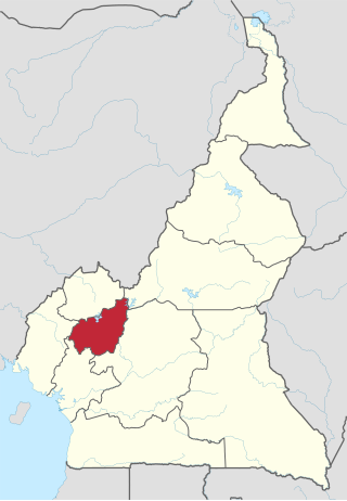
The West Region is 14,000 km2 of territory located in the central-western portion of the Republic of Cameroon. It borders the Northwest Region to the northwest, the Adamawa Region to the northeast, the Centre Region to the southeast, the Littoral Region to the southwest, and the Southwest Region to the west. The West Region is the smallest of Cameroon's ten regions in area, yet it has the highest population density.

The Mandara Mountains are a volcanic range extending about 190 km along the northern part of the Cameroon–Nigeria border, from the Benue River in the south to the north-west of Maroua in the north. The highest elevation is the summit of Mount Oupay, at 1,494 m (4,900 ft) above sea level.

Bana is a sub-prefecture and commune in the West Province of Cameroon, some 8 km east of Bafang and 2 km south-west of Babouantou.

The geology of Minnesota comprises the rock, minerals, and soils of the U.S. state of Minnesota, including their formation, development, distribution, and condition.

The Cameroon line is a 1,600 km (1,000 mi) long chain of volcanoes that includes islands in the Gulf of Guinea and mountains on the African mainland, from Mount Cameroon on the coast towards Lake Chad on the northeast. They form a natural border between eastern Nigeria and the West Region of Cameroon. The islands, which span the equator, have tropical climates and are home to many unique plant and bird species. The mainland mountain regions are much cooler than the surrounding lowlands, and also contain unique and ecologically important environments.

The Western High Plateau, Western Highlands or Bamenda Grassfields is a region of Cameroon characterised by high relief, cool temperatures, heavy rainfall and savanna vegetation. The region lies along the Cameroon line and consists of mountain ranges and volcanoes made of crystalline and igneous rock. The region borders the South Cameroon Plateau to the southeast, the Adamawa Plateau to the northeast and the Cameroon coastal plain to the south.
The Atlantika Mountains, also known as the Alantika Mountains, are an extension of the Cameroon line of volcanic mountains, spanning the border between Nigeria and Cameroon. They lie to the southeast of Yola, the capital of Adamawa State in Nigeria, and southwest of the Mandara mountains. In Cameroon, they are part of the North Region. They are north of the Adamawa Plateau and west of the Faro National Park in Cameroon. The massif rises to about 1,300 metres (4,300 ft) above the Faro River, a tributary of the Benue River. The range includes a belt of volcanoes, most of which are inactive. The mountains' landscape includes outcrops of large granite boulders.

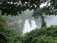
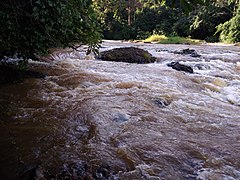
The Nkam River rises in the Western High Plateau in the West Region of Cameroon, and joins the Makombé River to become the Wouri River. It is known to tourists for the spectacular Chutes d'Ekom, an 80 metres (260 ft) high waterfall about 30 kilometres (19 mi) from Bafang. To the south of the town of Dschang, the Santchou Faunal Reserve lies to the east of the river.

The Menchum River and its tributaries drains a large area of the Northwest Region of Cameroon. It in turn is a tributary of the Benue River in Nigeria.
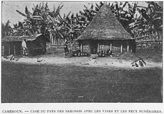
The Bakossi people are a Bantu ethnic group that live on the western and eastern slopes of Mount Mwanenguba and Mount Kupe in the Bakossi Mountains of Cameroon. They number about 200,000, mostly engaged in subsistence farming but also producing some coffee and cocoa.
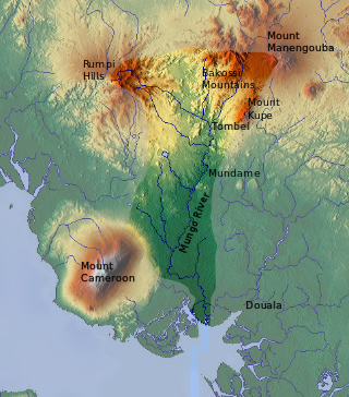
The Mungo River is a large river in Cameroon that drains the mountains in the southern portion of the Cameroon line of active and extinct volcanoes.

The Rumpi Hills are an undulating mountain range with its highest peak, Mount Rata about 1,800 m (5,900 ft) located between the villages of Dikome Balue and Mofako Balue, Ndian division in the Southwest region of Cameroon. The hills are situated at 4°50’N 9°07’E, cutting across four local councils, with the eastern slopes in Dikome Balue, southern slopes in Ekondo Titi, western slopes in Mundemba, and northern slopes in Toko local councils respectively. These hills are located about 80 km (50 mi) north of Mount Cameroon; about 50 km (31 mi) west of the Bakossi Mountains and some 15 km (9.3 mi) southeast of the Korup National Park.
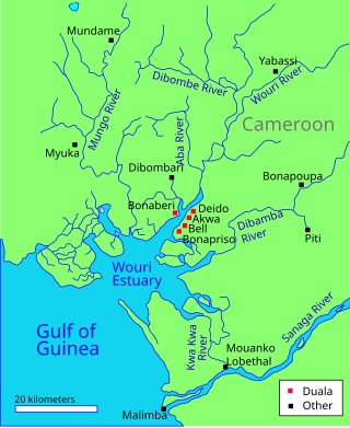
The Wouri estuary, or Cameroon estuary is a large tidal estuary in Cameroon where several rivers come together, emptying into the Bight of Biafra. Douala, the largest city in Cameroon, is at the mouth of the Wouri River where it enters the estuary. The estuary contains extensive mangrove forests, which are being damaged by pollution and population pressures.
The Mbo people are a Bantu group of the Mbo plain, Littoral Region, Mungo Division, Nkongsamba, Southwest Region and Melong subdivisions and in the West Region, Menoua Division, Santchou Subdivision and Upper Nkam Division, Kekem Subdivision of Cameroon.

Albert Ndongmo was Bishop of Nkongsamba in Cameroon between June 1964 and January 1973. In 1970 he was arrested, accused of treasonous dealings with rebels, and sentenced to death by a military tribunal. His sentence was later commuted to life imprisonment, of which he served five years before the President ordered his release. After being released he moved to Rome and then to Canada, where he spent the rest of his life.
Paul Bouque was Bishop of Nkongsamba, Cameroon, from September 1955 until 16 June 1964, when he resigned.
The geology of Cameroon is almost universally Precambrian metamorphic and igneous basement rock, formed in the Archean as part of the Congo Craton and the Central African Mobile Zone and covered in laterite, recent sediments and soils. Some parts of the country have sequences of sedimentary rocks from the Paleozoic, Mesozoic and Cenozoic as well as volcanic rock produced by the 1600 kilometer Cameroon Volcanic Line, which includes the still-active Mount Cameroon. The country is notable for gold, diamonds and some onshore and offshore oil and gas.