
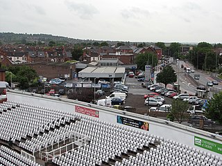
Melton Mowbray is a town in Leicestershire, England, 19 miles (31 km) north-east of Leicester, and 20 miles (32 km) south-east of Nottingham. It lies on the River Eye, known below Melton as the Wreake. The town had a population 27,670 in 2019. The town is sometimes promoted as Britain's "Rural Capital of Food". Melton's culinary specialities are Stilton cheese and the Melton Mowbray pork pie. It is also the location of one of six licensed makers of Stilton itself.

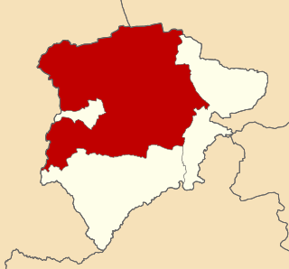
Melton is a local government district with borough status in north-eastern Leicestershire, England. It is named after its main town, Melton Mowbray. Other settlements include Asfordby and Bottesford. At the 2011 census, it had a population of 50,376.
Rushcliffe is a local government district with borough status in Nottinghamshire, England. The population of the Local Authority at the 2011 Census was 111,129. Its council, Rushcliffe Borough Council(0115 981 9911), is based in West Bridgford. It was formed on 1 April 1974 by merging the West Bridgford Urban District, the Bingham Rural District and part of Basford Rural District.

Rural districts were a type of local government area – now superseded – established at the end of the 19th century in England, Wales, and Ireland for the administration of predominantly rural areas at a level lower than that of the administrative counties.
The history of the English county of Rutland, located in the East Midlands. It was reconstituted as a district of Leicestershire in 1974 by the Local Government Act 1972. This district was given unitary authority status on 1 April 1997.

The Vale of Belvoir covers adjacent areas of Leicestershire, Nottinghamshire and Lincolnshire, England. The name derives from the Norman-French for "beautiful view" and dates back to Norman times.
Croxton Kerrial is a village and civil parish in the Melton borough of Leicestershire, England, 6.6 miles (10.6 km) south-west of Grantham, 7.9 miles (12.7 km) north-east of Melton Mowbray, and 0.5 miles (0.8 km) west of Leicestershire's border with Lincolnshire. The civil parish includes the village of Branston and had a population of 530 at the 2011 census.
The rural district of Hallaton existed in Leicestershire, England from 1894 to 1935. It included the following civil parishes, which were the parts of the Uppingham Rural Sanitary District in Leicestershire.
Oakham was a rural district in Rutland, England from 1894 to 1974, covering the north of the county.
Belvoir was a rural district in Leicestershire, England from 1894 to 1935.
Melton was a rural district in Leicestershire, England from 1894 to 1935.

Holwell Sports Football Club is a football club based in Asfordby Hill, near Melton Mowbray, Leicestershire, England. They are currently members of the United Counties League Division One and play at Welby Road.
Melton was a county constituency centred on the town of Melton Mowbray in Leicestershire. It returned one Member of Parliament (MP) to the House of Commons of the Parliament of the United Kingdom.
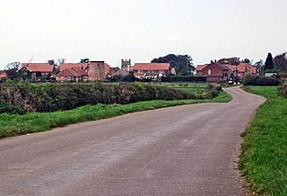
Stathern is an English village and civil parish in the Melton district of Leicestershire. It lies in the Vale of Belvoir about 10 miles (16 km) north of Melton Mowbray. Its church has an unusual dedication and its school a long history. Its pub doubles as a post office.
The River Eye is a slow-flowing river in north-eastern Leicestershire that becomes the Wreake.

Stonesby is a small village within the Melton borough of Leicestershire, England. It is 6 miles (9.7 km) northeast of Melton Mowbray, and 1.5 miles (2.4 km) southeast of Waltham on the Wolds. The population is included in the civil parish of Sproxton.
Ankle Hill is a hill located in the centre of Melton Mowbray, in Leicestershire. In the civil war the town of Melton Mowbray was the theatre of a battle between Sir Marmaduke Langdale's Royalist force of 1,500 men and the Roundhead garrison commanded by Colonel Rossiter which was stationed in the town. The battle took place on a hillside near the present day town centre, and it is said that the blood of the slaughtered Roundheads pooled ankle deep at its base. Thenceforth the hill was known as Ankle Hill, however at some point in history the names of Dalby Road and Ankle Hill were unintentionally swapped in error, however were never changed back.

Saxelbye is a small village in the district of Melton in Leicestershire, England. The village lies about three miles to the north-west of Melton Mowbray and is situated on the southern slope of the ridge that makes up the southern boundary of the Vale of Belvoir. In 1931 the parish had a population of 75.

Melton Town Football Club is a football club based in Melton Mowbray, Leicestershire, England. They are currently members of the United Counties League Premier Division North and play at the Melton Sports Village.
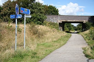
National Cycle Network (NCN) Route 64 is a Sustrans National Route that runs from Market Harborough to Lincoln. The route is 68 miles (109 km) in length and is fully open and signed in both directions. There are three sections to the route, NCN 63 and NCN 15 form the links between these sections.
This page is based on this
Wikipedia article Text is available under the
CC BY-SA 4.0 license; additional terms may apply.
Images, videos and audio are available under their respective licenses.