
Fjell is a former municipality in the old Hordaland county, Norway. It is part of the traditional district of Midhordland. The municipality consisted of several islands west of the city of Bergen, the major ones being Litlesotra, the northern part of Store Sotra, Bildøy, Bjorøy, Misje, and Turøy. The administrative centre of Fjell is the village of Straume. Some of the villages in Fjell included Ågotnes, Fjell, Foldnes, Knappskog, Knarrevik, Kolltveit, Landro, and Sekkingstad. On 1 January 2020, the municipality became part of Øygarden Municipality in Vestland county.

Nesna is a municipality in Nordland county, Norway. It is part of the Helgeland traditional region. The administrative centre of the municipality is the village of Nesna. Other villages in Nesna include Handnesneset, Husby, Saura, and Vikholmen.
Rødøy is a municipality in Nordland county, Norway. It is part of the Helgeland traditional region. The administrative centre of the municipality is the village of Vågaholmen. Other villages include Gjerøy, Jektvika, Kilboghamn, Melfjordbotn, Oldervika, Sørfjorden, and Tjong. The municipality consists of many islands to the west of Norway's second biggest glacier, Svartisen.

Meløy is a municipality in Nordland county, Norway. It is part of the Salten traditional region. The administrative centre of the municipality is the village of Ørnes. Other villages include Eidbukta, Neverdal, Glomfjord, Halsa, Reipå, Støtt, and Ågskardet.

Øksnes is a municipality in Nordland county, Norway. It is located on the northwestern part of the large island of Langøya, which is a part of the traditional region of Vesterålen. The administrative centre of the municipality is the village of Myre. Other villages in Øksnes include Alsvåg, Barkestad, Breidstrand, Nyksund, Strengelvåg, and Stø.

Bolga is an island in the municipality of Meløy in Nordland county, Norway. The 2.4-square-kilometre (0.93 sq mi) island has a population (2017) of 105. It is located west of the islands of Meløya and Åmøya, just off the coast of the Helgeland region. The highest point on the island is the 339-metre (1,112 ft) tall Bolgtinden. Most of the population of the island lives along the eastern shore in the village that is also known as Bolga. It is the only village on the island. There are regular ferry connections from Bolga to the islands of Meløya to the east and to Vassdalsvik and Ørnes on the mainland.
Ørnes is the administrative centre of the municipality of Meløy in Nordland county, Norway. The old village is mentioned in documents dating from 1610 when a tenant farmer lived here. It is located along Norwegian County Road 17, about 6 kilometres (3.7 mi) south of the village of Reipå and about 5 kilometres (3.1 mi) north of the village of Eidbukta. The island of Mesøya lies just west of the village. Ørnes is a port of call along the Hurtigruten ferry route between Nesna and Bodø. The newspapers Framtia and Meløyavisa are published in Ørnes.

Hafslo is a former municipality in the old Sogn og Fjordane county, Norway. The 538-square-kilometre (208 sq mi) municipality existed from 1838 until its dissolution in 1963. It is located in the present-day Luster Municipality in the traditional district of Sogn. The former municipality included the villages of Kinsedalen, Ornes, and Kroken on the east side of the Lustrafjorden. It also included the villages of Solvorn, Hafslo, Joranger, and the whole Veitastrond valley on the west side of the Lustrafjorden. The municipality surrounded the lakes Hafslovatnet and Veitastrondvatnet. The administrative centre of the municipality was the village of Hafslo, where Hafslo Church was located.
Lysvatnet is a lake that lies in the municipality of Meløy in Nordland county, Norway. The 4.53-square-kilometre (1.75 sq mi) is located near the border with Gildeskål Municipality, about 5.5 kilometres (3.4 mi) east of the municipal centre of Ørnes. The lake Markavatnet lies about 3 kilometres (1.9 mi) to the west of this lake.
Markavatnet or Markvatnet is a lake that lies in the municipality of Meløy in Nordland county, Norway. The 2.28-square-kilometre (0.88 sq mi) lake is located about 4 kilometres (2.5 mi) east of the village of Reipå and the same distance north of the municipal centre of Ørnes. The lake Lysvatnet lies about 3 kilometres (1.9 mi) to the east of Markavatnet.

Bremsnes is a former municipality in Møre og Romsdal county, Norway. The 120-square-kilometre (46 sq mi) municipality existed from 1897 until its dissolution in 1964. Bremsnes municipality surrounded the Bremsnesfjorden and it included parts of the islands of Averøya, Frei, and Nordlandet. Bremsnes essentially encircled the town of Kristiansund on the west, south, and east sides. The administrative centre of Bremsnes was the village of Bremsnes, where Bremsnes Church is located.

Reipå is a village in the municipality of Meløy in Nordland county, Norway. It is located along Norwegian County Road 17 about 6 kilometres (3.7 mi) north of the village of Ørnes. The lakes Lysvatnet and Markavatnet both lie to the east of the village. Fore Church is located in Reipå, serving northern Meløy.
Mesøya or Mesøy is an island in the municipality of Meløy in Nordland county, Norway. The island is located just southwest of the village of Ørnes on the mainland and east of the island of Meløya. The island sits at the mouth of the Glomfjorden. Mesøya is only accessible by boat, and it has no regular ferry service. Mesøya has an area of 8 square kilometres (3.1 sq mi) and the highest point on the island is the 364-metre (1,194 ft) tall Mesøytoppen.
Eidbukta is a village in the municipality of Meløy in Nordland county, Norway. It is located along Norwegian County Road 17, about 5 kilometres (3.1 mi) south of the municipal centre of Ørnes. The village lies at the entrance to the Glomfjorden. The 0.71-square-kilometre (180-acre) village has a population (2018) of 572 and a population density of 806 inhabitants per square kilometre (2,090/sq mi).

Kalsholmen Lighthouse is a coastal lighthouse in Meløy Municipality in Nordland county, Norway. It is located on the small island of Kalsholmen, about 15 kilometres (9.3 mi) west of the village of Støtt and 12 kilometres (7.5 mi) northwest of the village of Bolga.

Åmøya is an island in the municipality of Meløy in Nordland county, Norway. The 23.4-square-kilometre (9.0 sq mi) island lies west of the mainland, east of the island of Bolga, and south of the island of Meløya. The island is connected to the mainland by a series of small bridges over the island of Grønnøya and several other small islands between Åmøya and the village of Engavågen on the mainland. The island is very mountainous, the highest mountain is the 648-metre (2,126 ft) Risnestinden. There were 112 residents living on the island in 2016.
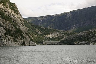
Glomfjorden is a fjord in the municipality of Meløy in Nordland county, Norway. The fjord is located just north of the Svartisen glacier between some very steep mountains that lie along the edges of the fjord. The villages of Glomfjord and Vassdalsvik are located along the fjord. The island of Messøya is located at the mouth of the fjord, near the village of Ørnes. The 21-kilometre (13 mi) long fjord is about 1 to 3 kilometres wide.
Ørnes Chapel is a chapel of the Church of Norway in Meløy Municipality in Nordland county, Norway. It is located in the village of Ørnes. It is an annex chapel in the Fore og Meløy parish which is part of the Bodø domprosti (deanery) in the Diocese of Sør-Hålogaland. The white, wooden chapel was built in a long church style in 1990. The chapel seats about 300 people as well as houses the parish offices.
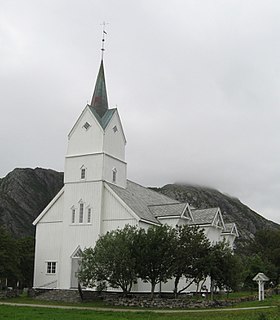
Meløy Church is a parish church of the Church of Norway in Meløy Municipality in Nordland county, Norway. It is located in the village of Meløy on the island of Meløya. It is one of the churches for the Fore og Meløy parish which is part of the Bodø domprosti (deanery) in the Diocese of Sør-Hålogaland. The white, wooden church was built in a long church style in 1867 using plans drawn up by the architects Håkon Mosling and Jacob Wilhelm Nordan. The church seats about 600 people, making it the second-largest wooden church in all of Northern Norway.

Støttvær is a group of islands in Meløy Municipality in Nordland county, Norway. The islands lie about 10 kilometres (6.2 mi) northwest of the mainland village of Reipå. The main islands of Støttvær include the 1.6-square-kilometre (0.62 sq mi) Svenningen, the 2.7-square-kilometre (1.0 sq mi) Innerstøtt, and the 1.4-square-kilometre (0.54 sq mi) Helløya. There are also many other uninhabited smaller islands and skerries surrounding the main islands. Innerstøtt and Svenningen are inhabited and they are connected to each other by bridges. There were 27 residents in Støttvær in 2017. There is a car ferry from Innerstøtt to the mainland village of Ørnes. The two inhabited islands are also referred to as the village of Støtt.


