Related Research Articles

Svalbard and Jan Mayen is a statistical designation defined by ISO 3166-1 for a collective grouping of two remote jurisdictions of Norway: Svalbard and Jan Mayen. While the two are combined for the purposes of the International Organization for Standardization (ISO) category, they are not administratively related. This has further resulted in the country code top-level domain .sj being issued for Svalbard and Jan Mayen, and ISO 3166-2:SJ. The United Nations Statistics Division also uses this code, but has named it Svalbard and Jan Mayen Islands.

Danes Island is an island in Norway's Svalbard archipelago in the Arctic Ocean. It lies just off the northwest coast of Spitsbergen, the largest island in the archipelago, near to Magdalenefjorden. Just to the north lies Amsterdam Island. Like many of Svalbard's islands, Danes Island is uninhabited. The island has an area of 40.6 km2 (15.7 sq mi).

Hinlopen Strait is the strait between Spitsbergen and Nordaustlandet in Svalbard, Norway. It is 150 kilometers (93 mi) long and 10 to 60 kilometers wide. The strait is difficult to pass because of pack ice. It is believed to have been named after Thijmen Jacobsz Hinlopen.

Ytre Norskøya is an island on the northwest coast of Spitsbergen, part of the Svalbard archipelago.
Vestfonna is an ice cap located on the western part Nordaustlandet in the Svalbard archipelago in Norway. The glacier covers an area of about 2,500 km2. It is the third largest ice cap in Svalbard and Norway by area, after Austfonna and Olav V Land.
Haakon VII Land is a land area at the northwestern part of Spitsbergen, Svalbard, between Woodfjorden and Kongsfjorden.
Albert I Land is the land area of the northwestern part of Spitsbergen, Svalbard. It is bordered by Haakon VII Land to the southeast. To the northeast lies Raudfjorden and its inner branch, Klinckowströmfjorden, to the southeast Krossfjorden and its inner branch, Lilliehöökfjorden, to the west and north the Arctic Ocean.
Andrée Land is the land area between Wijdefjorden and Woodfjorden on Spitsbergen, Svalbard in Arctic Norway. Limited in the south by a line from Woodfjorden through Vonbreen to Holtedahlfonna eastwards to the upper part of Abrahamsenbreen through Ruskbreen, Millarpasset, Lisbetbreen and Vestfjorddalen to Vestfjorden.
Ny-Friesland is the land area between Wijdefjorden and Hinlopen Strait on Spitsbergen, Svalbard.
Gustav Adolf Land is the land area of the southwestern part of Nordaustlandet, Svalbard, south of Wahlenbergfjorden. The area is named after Gustaf VI Adolf of Sweden.
Blomstrandhamna Bird Sanctuary is a bird reserve at Svalbard, Norway, established in 1973. It includes the skerry in Blomstrandhamna in Haakon VII Land. The protected area covers a total of 580,000 square metres.
Moseøya Bird Sanctuary is a bird reserve at Svalbard, Norway, established in 1973. It includes Moseøya, south of Danes Island, part of Albert I Land. The protected area covers a total area of around 1,400,000 square metres.
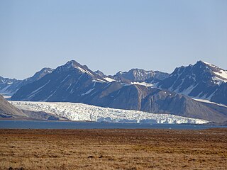
Blomstrandbreen is an glacier in Haakon VII Land at the western side of Spitsbergen, Svalbard. It has a length of 18 kilometres, extending from Isachsenfonna down to Kongsfjorden. The glacier is named after geologist Christian Wilhelm Blomstrand. To the northwest of the glacier is the mountain area of Mercantonfjellet.
Valhallfonna is an ice cap in Ny-Friesland at Spitsbergen, Svalbard. It is located west of Hinlopen Strait and northeast of Åsgardfonna. The glacier covers an area of about 1,000 km².
Blomstrandhamna is a bay in Haakon VII Land at Spitsbergen, Svalbard. It is located at the northern side of Kongsfjorden, north of Blomstrandhalvøya. The bay splits into the two branches Nordvågen and Sørvågen. Blomstrandhamna is connected with Dyrevika east of Blomstrandhalvøya. The connecting strait was earlier covered by the glacier Blomstrandbreen, and emerged after recent retreat of the glacier. A skerry in Blomstrandhamna and surrounding waters was included in the Blomstrandhamna Bird Sanctuary in 1973, covering an area of 0.58 square kilometers.
Woodfjorddalen is a valley in Andrée Land at Spitsbergen, Svalbard. It forms a southeastward continuation of the fjord Woodfjorden. The upper part of the valley is covered by the glacier Abrahamsenbreen. At the lower part of the valley is the flat sand and clay area Poninskiøyra and the hill Tantalushaugen. A side valley to the south is Piræusdalen, six kilometers from the head of Woodfjorden. North of the valley is the mountain group Vaktarfjella, with a length of about eleven kilometers.
Palanderisen is a glaciated area in Gustav Adolf Land at Nordaustlandet, Svalbard. It has an extension of about 35 kilometers and is part of the ice cap of Austfonna, located west of the Sørdomen ice dome, between Etonbreen and Ericadalen. The area is named after Arctic explorer Louis Palander. It includes Sørfonna.

Fjortende Julibreen is a glacier in Haakon VII Land at Spitsbergen, Svalbard. It has a length of about sixteen kilometers, and a total area of about 127 km2. It is located between Reppingen, Løvlandfjellet and Mercantonfjellet to the south, and Casimir-Périerkammen, Forelryggen and Foreltinden to the north, and extends down to Fjortende Julibukta in Krossfjorden. The glacier is named after the National Day of France, the 14 July.

Paul-Louis Mercanton was a Swiss glaciologist, meteorologist, and Arctic explorer.

Tinayrebreen is a glacier in Haakon VII Land at Spitsbergen, Svalbard. It has a length of about ten kilometers, and extends from the glacier cap of Isachsenfonna to Möllerfjorden, where it debouches into the bay of Tinayrebukta. The glacier is named after French painter Jean Paul Louis Tinayre.
References
- ↑ "Mercantonfjellet (Svalbard)". Norwegian Polar Institute . Retrieved 3 November 2013.
- ↑ Lauritzen, Per Roger, ed. (2009). "Mercantonfjellet". Norsk Fjelleksikon (in Norwegian). Arendal: Friluftsforlaget. ISBN 978-82-91-49547-7.
Coordinates: 79°05′56″N12°16′57″E / 79.0990°N 12.2826°E
| This Spitsbergen mountain, mountain range, or peak related article is a stub. You can help Wikipedia by expanding it. |