Mermaid's Pool to Rowden Gut

Last updated
Abbotsham Cliff Abbotsham Cliff - geograph.org.uk - 1302790.jpg
Abbotsham Cliff

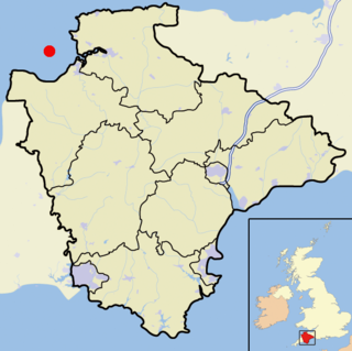
Mermaid's Pool to Rowden Gut is a geological Site of Special Scientific Interest (SSSI) in north-western Devon in England. It comprises a 5.5km-long stretch of coast between Mermaid's Pool in the north-east and Rowden's Gut in the south-west. The sea cliffs expose the only available complete sequence through the Bideford Formation of the Culm Measures, which consists of alternating layers of mudstones, siltstones and sandstones [1] that were deposited in a wide range of deltaic environments during the Carboniferous period. [2] This site borders the Westward Ho! Cliffs SSSI to the north, while the coastline to the south-east continues to Peppercombe, and further into the Hobby to Peppercombe SSSI.

Site of Special Scientific Interest Conservation designation denoting a protected area in the United Kingdom

A Site of Special Scientific Interest (SSSI) in Great Britain or an Area of Special Scientific Interest (ASSI) in the Isle of Man and Northern Ireland is a conservation designation denoting a protected area in the United Kingdom and Isle of Man. SSSI/ASSIs are the basic building block of site-based nature conservation legislation and most other legal nature/geological conservation designations in the United Kingdom are based upon them, including national nature reserves, Ramsar sites, Special Protection Areas, and Special Areas of Conservation. The acronym "SSSI" is often pronounced "triple-S I".

Devon County of England

Devon, also known as Devonshire, which was formerly its common and official name, is a county of England, reaching from the Bristol Channel in the north to the English Channel in the south. It is part of South West England, bounded by Cornwall to the west, Somerset to the north east, and Dorset to the east. The city of Exeter is the county town. The county includes the districts of East Devon, Mid Devon, North Devon, South Hams, Teignbridge, Torridge, and West Devon. Plymouth and Torbay are each geographically part of Devon, but are administered as unitary authorities. Combined as a ceremonial county, Devon's area is 6,707 km2 and its population is about 1.1 million.

Culm Measures

The Culm Measures are a thick sequence of geological strata originating during the Carboniferous Period that occur in south-west England, principally in Devon and Cornwall, now known as the Culm Supergroup. Its estimated thickness varies between 3600 m and 4750 m though intense folding complicates it at outcrop. They are so called because of the occasional presence in the Barnstaple–Hartland area of a soft, often lenticular, sooty coal, which is known in Devon as culm. The word culm may be derived from the Old English word for coal col or from the Welsh word cwlwm meaning knot.

Mermaid's Pool is in the centre, with the sandstone reef behind. Mermaid's Pool Westward Ho^ - geograph.org.uk - 130804.jpg
Mermaid's Pool is in the centre, with the sandstone reef behind.

Mermaid's Pool is a little pool in the shore platform a mile west of Westward Ho! It borders on a reef of hard sandstone which stands out against the surrounding gullies formed of easily eroded softer mudstone, now covered in algae. Several minor faults are visible along the length of the reef. [3] There is bladder wrack growing in the area supporting a population of flat periwinkles, which are otherwise not found on the rocky platforms to the east in Westward Ho! [4]

Westward Ho! village in the United Kingdom

Westward Ho! is a seaside village near Bideford in Devon, England. The A39 road provides access from the towns of Barnstaple, Bideford and Bude. It lies at the south end of Northam Burrows and faces westward into Bideford Bay, opposite Saunton Sands and Braunton Burrows. There is an electoral ward with the same name. The population at the 2011 census was 2,112.

In geology, a fault is a planar fracture or discontinuity in a volume of rock, across which there has been significant displacement as a result of rock-mass movement. Large faults within the Earth's crust result from the action of plate tectonic forces, with the largest forming the boundaries between the plates, such as subduction zones or transform faults. Energy release associated with rapid movement on active faults is the cause of most earthquakes.

Littorinidae family of molluscs

The Littorinidae are a taxonomic family of over 200 species of sea snails, marine gastropod molluscs in the clade Littorinimorpha, commonly known as periwinkles and found worldwide.

Related Research Articles

Old Red Sandstone assemblage of rocks in the North Atlantic region

The Old Red Sandstone is an assemblage of rocks in the North Atlantic region largely of Devonian age. It extends in the east across Great Britain, Ireland and Norway, and in the west along the northeastern seaboard of North America. It also extends northwards into Greenland and Svalbard. In Britain it is a lithostratigraphic unit to which stratigraphers accord supergroup status and which is of considerable importance to early paleontology. For convenience the short version of the term, ORS is often used in literature on the subject. The term was coined to distinguish the sequence from the younger New Red Sandstone which also occurs widely throughout Britain.

Northam, Devon town and civil parish in Devon, England

Northam is a small town, civil parish and electoral ward in Devon, England, lying north of Bideford. The civil parish also includes the villages of Westward Ho!, Appledore, West Appledore, Diddywell, Buckleigh and Silford, and the residential areas of Orchard Hill and Raleigh Estate. The population at the 2011 census was 5,427.

St Brides Bay bay in Pembrokeshire, Wales

St Brides Bay is a bay in western Pembrokeshire, West Wales.

Geology of the Capitol Reef area

The exposed geology of the Capitol Reef area presents a record of mostly Mesozoic-aged sedimentation in an area of North America in and around Capitol Reef National Park, on the Colorado Plateau in southeastern Utah.

Geology of South Wales

South Wales is an area with many features of outstanding interest to geologists, who have for long used the area for University field trips.

Geology of Cornwall

The geology of Cornwall, England, is dominated by its granite backbone, part of the Cornubian batholith, formed during the Variscan orogeny. Around this is an extensive metamorphic aureole formed in the mainly Devonian slates that make up most of the rest of the county. There is an area of sandstone and shale of Carboniferous age in the north east, and the Lizard peninsula is formed of a rare section of uplifted oceanic crust.

Peppercombe area in Devon, England

Peppercombe is a small valley (combe) on the north-western coast of Devon, England. It is situated on the South West Coast Path between Westward Ho! to the north and Bucks Mills to the west. There is also a path descending from Horns Cross on the A39 road. The small stream of Peppercombe Water is a little over a kilometre long, but its valley is relatively deep. It ends in a waterfall consisting in a series of cascades, each between 0.5 and 1.5 metres high, that have formed due to the unequal hardness of the different beds of the underlying rock. The seaward section of Peppercombe is at the eastern end of the Hobby to Peppercombe biological Site of Special Scientific Interest (SSSI), while the coast section to north-east is part of the Mermaid's Pool to Rowden Gut geological SSSI.

The Cheshire Basin is a late Palaeozoic and Mesozoic sedimentary basin extending under most of the county of Cheshire in northwest England. It extends northwards into the Manchester area and south into Shropshire. The basin possesses something of the character of a half-graben as its deepest extent is along its eastern and southeastern margins, where it is well defined by a series of sub-parallel faults, most important of which is the Red Rock Fault. These faults divide the basin from the older Carboniferous rocks of the Peak District and the North Staffordshire Coalfield.

Bideford Bay

Bideford Bay, also known as Barnstaple Bay and often shown on maps as Barnstaple or Bideford Bay, is a large area of water on the northwest coast of Devon in South West England, at the southwestern end of the Bristol Channel where it joins the Celtic Sea. The bay extends from Hartland Point in the southwest to Morte Point in the northeast, a distance of 14 miles (23 km), and is partly sheltered by the island of Lundy, 12 miles (19 km) offshore. It takes its alternative names from the towns of Bideford and Barnstaple, located respectively on the rivers Torridge and Taw which flow into the bay. The alternative spelling Barnstable Bay, in use long after that spelling became obsolete for the town, is also sometimes seen.

Geology of East Sussex

The geology of East Sussex is defined by the Weald–Artois anticline, a 60 kilometres (37 mi) wide and 100 kilometres (62 mi) long fold within which caused the arching up of the chalk into a broad dome within the middle Miocene, which has subsequently been eroded to reveal a lower Cretaceous to Upper Jurassic stratigraphy. East Sussex is best known geologically for the identification of the first dinosaur by Gideon Mantell, near Cuckfield, to the famous hoax of the Piltdown man near Uckfield.

The geology of Monmouthshire in southeast Wales largely consists of a thick series of sedimentary rocks of different types originating in the Silurian, Devonian, Carboniferous, Triassic and Jurassic periods.

Southerndown Coast

Southerndown Coast is a Site of Special Scientific Interest (SSSI) in St Brides Major community, in the Vale of Glamorgan, South Wales. It forms part of the Glamorgan Heritage Coast, bordered by the Monknash Coast to the southeast. The nearby villages are Southerndown and Ogmore-by-Sea. The SSSI extends over 5 kilometres of south-west facing coastline, with rocky limestone cliffs, broad beaches and deeply fissured wave-cut platforms.

Steeple Point to Marsland Mouth human settlement in United Kingdom

Steeple Point to Marsland Mouth is a coastal Site of Special Scientific Interest (SSSI) in Cornwall, England, UK, noted for its biological characteristics.

Duckpool to Furzey Cove human settlement in United Kingdom

Duckpool to Furzey Cove is a coastal Geological Conservation Review site and Site of Special Scientific Interest (SSSI) in north Cornwall, England, UK, noted for its geological interest.

Esplanade Sandstone

The Lower Permian Esplanade Sandstone is a cliff-forming, resistant sandstone, dark red, geologic unit found in the Grand Canyon. The rock unit forms a resistant shelf in the west Grand Canyon, south side of the Colorado River, at the east of the Toroweap Fault, down-dropped to west, southeast of Toroweap Overlook, and west of Havasupai. The red, sandstone shelf, The Esplanade is about 20-mi long. At Toroweap Overlook region, Toroweap Valley with Vulcan's Throne, Uinkaret volcanic field, the resistant Esplanade Sandstone is described in access routes exploring the Toroweap Lake area.

The geology of Lancashire in northwest England consists in the main of Carboniferous age rocks but with Triassic sandstones and mudstones at or near the surface of the lowlands bordering the Irish Sea though these are largely obscured by Quaternary deposits.

The geology of Merseyside in northwest England largely consists of a faulted sequence of Carboniferous Coal Measures rocks overlain in the west by younger Triassic and Permian age sandstones and mudstones. Glaciation during the present Quaternary Period has left widespread glacial till as well as erosional landforms. Other post-glacial superficial deposits such as river and estuarine alluvium, peat and blown sand are abundant.

References

Bibliography

International Standard Book Number Unique numeric book identifier

The International Standard Book Number (ISBN) is a numeric commercial book identifier which is intended to be unique. Publishers purchase ISBNs from an affiliate of the International ISBN Agency.