Meru may refer to:
Meru may refer to:

Arusha City is a Tanzanian city, with a population of 617,631, and the regional capital of the Arusha Region, with a population of 2,356,255.

The Chagga are a Bantu ethnic group from Kilimanjaro Region of Tanzania. They are the third-largest ethnic group in Tanzania. They historically lived in sovereign Chagga states on the slopes of Mount Kilimanjaro in both Kilimanjaro Region and eastern Arusha Region.

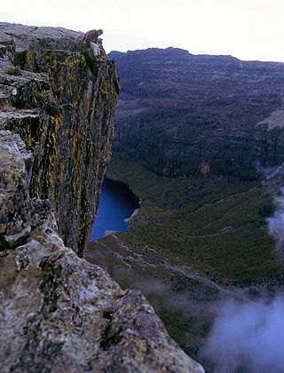
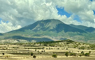
Mount Meru is a dormant stratovolcano located 70 kilometres (43 mi) west of Kilimanjaro in southeast Arusha Region, Tanzania. At a height of 4,562.13 metres (14,968 ft), it is visible from Mount Kilimanjaro on a clear day, and is the fifth-highest of the highest mountain peaks of Africa, dependent on definition.
Meru County is one of the 47 counties of Kenya. It borders Isiolo County to the north, Tharaka-Nithi County to the South, Nyeri County to the southwest and Laikipia County to the west. The home of the Meru people, Meru County has a population of 1.35 million people.

Kilimanjaro Region is one of Tanzania's 31 administrative regions. The regional capital and largest city is the municipality of Moshi. With the 3rd highest HDI of 0.640 in the country, Kilimanjaro is one among the top five most developed regions of Tanzania. According to the 2012 national census, the region had a population of 1,640,087, which was lower than the pre-census projection of 1,702,207. For 2002–2012, the region's 1.8 percent average annual population growth rate was the 24th highest in the country. It was also the eighth most densely populated region with 124 people per square kilometer. The most well-known tribes in the Kilimanjaro region are the chagga, rombos, and pare.
Manyara Region is one of Tanzania's 31 administrative regions. The regional capital is the town of Babati. According to the 2012 national census, the region had a population of 1,425,131, which was lower than the pre-census projection of 1,497,555. For 2002–2012, the region's 3.2 percent average annual population growth rate was tied for the third highest in the country. It was also the 22nd most densely populated region with 32 people per square kilometre.
Arusha Region is one of Tanzania's 31 administrative regions and is located in the northeast of the country. The region's capital and largest city is the city of Arusha. The region is bordered by Kajiado County and Narok County in Kenya to the north, the Kilimanjaro Region to the east, the Manyara and Singida Regions to the south, and the Mara and Simiyu regions to the west. Arusha Region is home to Ngorongoro Conservation Area, a UNESCO World Heritage Site. The region is comparable in size to the combined land and water areas of the state of Maryland in the United States.

Arusha National Park covers Mount Meru, a prominent volcano with an elevation of 4566 m, in the Arusha Region of north eastern Tanzania. The park is small but varied with spectacular landscapes in three distinct areas. In the west, the Meru Crater funnels the Jekukumia River; the peak of Mount Meru lies on its rim. Ngurdoto Crater in the south-east is grassland. The shallow alkaline Momella Lakes in the north-east have varying algal colours and are known for their wading birds.
Arusha City Council is one of seven administrative districts of Arusha Region in Tanzania. It is surrounded to the south, west and north by Arusha Rural District and to east by Meru District. The district covers an area of 267.0 km2 (103.1 sq mi). The district is comparable in size to the land area of Cayman Islands. The district capital is the city of Arusha. As of 1994, Arusha District was the wealthiest district in Tanzania. According to the 2022 Tanzania National Census, the population of Arusha Urban District was 617,631.

Same is one of the seven districts of the Kilimanjaro Region of Tanzania. It is bordered to the north by the Mwanga District, to the northeast by Kenya, to the south and southeast by the Korogwe District and Lushoto District of Tanga Region, and to the west by Simanjiro District of Manyara Region. The district capital is the town of Same, Tanzania. The south Pare Mountains are located within the district's boundaries and so is a part of Mkomazi National Park. According to the 2002 Tanzania National Census, the population of the Same District was 212,235. The population had risen to 300,303 according to the 2022 Tanzania National Census.

The Arusha people are a Bantu ethnic and indigenous group based in the western slopes of mount Meru in Arusha District of Arusha Region in Tanzania. The Maasai regard the Arusha people as related as they were once a part of the immigrant Maasai whom arrived in Arusha in the late 18th century from Kenya. The Arusha people are not to be confused by Arusha residents who are a mix of people of different ethnic backgrounds that are born and reside within the borders of the Arusha Region.

Meru District, officially the Meru District Council is one of seven districts of the Arusha Region of Tanzania.The District is bordered to the north by Longido District, to the east by Siha and Hai Districts of Kilimanjaro Region, to the south by Simanjiro District of Manyara Region, and to the west by Arusha Rural District and Arusha Urban District. It covers an area of 1,266 km2 (489 sq mi). The district is comparable in size to the land area of Faroe Islands. Meru District has an max elevation of 3,800 m (12,500 ft) at Rhino Point on Mount Meru. The administrative capital of the district is Usa River. According to the 2022 Tanzania National Census, the population of Meru District council was 331,603.
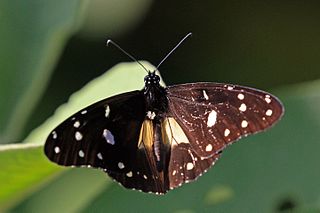
Amauris echeria, the chief, is a butterfly of the family Nymphalidae. It is found in southern Africa.
Mount Meru, or Sumeru, is the sacred five-peaked mountain of Hindu, Jain, and Buddhist cosmology.

Tanzania contains some 20 percent of the species of Africa's large mammal population, found across its reserves, conservation areas, marine parks, and 17 national parks, spread over an area of more than 42,000 square kilometres (16,000 sq mi) and forming approximately 38 percent of the country's territory. Wildlife resources of Tanzania are described as "without parallel in Africa" and "the prime game viewing country". Serengeti National Park, the country's second largest national park area at 14,763 square kilometres (5,700 sq mi), is located in northern Tanzania and is famous for its extensive migratory herds of wildebeests and zebra while also having the reputation as one of the great natural wonders of the world. The Ngorongoro Conservation Area, established in 1959, is a UNESCO World Heritage Site and inhabited by the Maasai people. Its Ngorongoro Crater is the largest intact caldera in the world.

The East African montane forests is a montane tropical moist forest ecoregion of eastern Africa. The ecoregion comprises several separate areas above 2000 meters in the mountains of South Sudan, Uganda, Kenya, and Tanzania.

The East African montane moorlands is a montane grasslands and shrublands ecoregion which occupies several high mountain peaks in Kenya, South Sudan, Tanzania, and Uganda.

Longido District is one of seven districts of the Arusha Region of Tanzania. The district is bordered to the east by the Ngorongoro District, to the south west by the Monduli District and southeast by the Arusha Rural District and Meru District. To the far east by Siha District of Kilimanjaro Region and the north by Kenya. It covers an area of 7,885 km2 (3,044 sq mi). The district is comparable in size to the land area of Puerto Rico.Longido District was created in 2007 from Monduli District. Mount Longido, Gelai and Kitumbeine volcano are all located within the boundaries of the district. The administrative seat is the town of Longido. According to the 2022 census, the population of the district was 175,915. Longido District is known as Arusha's gem district, as it is home to Anyolite and Rubies.
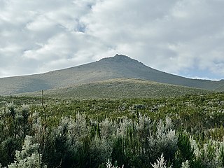
Mount Loolmalasin or Loolmalassin is a mountain located in the Ngorongoro District of the Arusha Region, Tanzania. It has a peak elevation of 3,682 metres (12,080 ft) above sea level. It is, after Mount Kilimanjaro and Mount Meru, the third-highest mountain in Tanzania if Kilimanjaro's three peaks are considered to be one mountain. The Mountain is located entirely within Nainokanoka ward. The volcano is located in the geographic area of the Crater Highlands and is an extinct volcano that last erupted in the pleistocene. Mount Loolmalasin is the second tallest mountain in Arusha Region and the highest point in Ngorongoro District. The mountain also is the source of Simiyu River, which flows west to Lake Victoria in Simiyu Region.

Arusha District or Arusha District Council is one of the seven districts of the Arusha Region of Tanzania. The district is bordered to the north by Longido District, to the east by Meru District, to the south by Kilimanjaro Region, and to the west by Monduli District. the district surrounds Arusha City on all three sides. The district covers an area of 1,547.6 km2 (597.5 sq mi). The district is comparable in size to the land area of Guadeloupe. The district capital is located in Sokon II. According to the 2022 Tanzania National Census, the population of Arusha District was 449,518.