Mesa (river)

Last updated
Mesa River (Río Mesa)

Balneario de Sicilia en Jaraba.jpg

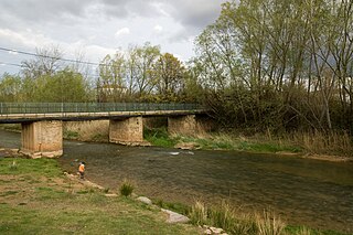
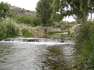
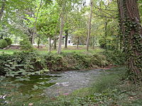
View of the Mesa River in Jaraba

Cuenca del rio Riedra.jpg

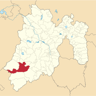
The watershed of the Piedra within the Ebro basin
Country Spain
Physical characteristics
Main source Sierra de Solorio,
Guadalajara Province
Castile-La Mancha
1,272 m (4,173 ft)
River mouth Piedra River
La Tranquera Dam, Aragón
691 m (2,267 ft)
41°14′33″N1°48′37″W / 41.24250°N 1.81028°W / 41.24250; -1.81028 Coordinates: 41°14′33″N1°48′37″W / 41.24250°N 1.81028°W / 41.24250; -1.81028
Length 54.17 kilometres (33.66 mi)
Basin features
Progression Piedra - Jalón- Ebro - Mediterranean Sea
River system Ebro

The Mesa River (Spanish : Río Mesa) is a river in the Sierra de Solorio range area, Iberian System, Spain. It is a tributary of the Piedra River.

Spanish language Romance language

Spanish or Castilian is a Romance language that originated in the Castile region of Spain and today has hundreds of millions of native speakers in the Americas and Spain. It is a global language and the world's second-most spoken native language, after Mandarin Chinese.

Sierra de Solorio

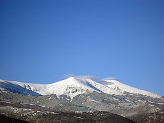
The Solorio Range is a mountain range located in the western side of the Iberian System, Spain. It straddles Aragon, Castile-La Mancha and Castile and León.

Spain Kingdom in Southwest Europe

Spain, officially the Kingdom of Spain, is a country mostly located in Europe. Its continental European territory is situated on the Iberian Peninsula. Its territory also includes two archipelagoes: the Canary Islands off the coast of Africa, and the Balearic Islands in the Mediterranean Sea. The African enclaves of Ceuta, Melilla, and Peñón de Vélez de la Gomera make Spain the only European country to have a physical border with an African country (Morocco). Several small islands in the Alboran Sea are also part of Spanish territory. The country's mainland is bordered to the south and east by the Mediterranean Sea except for a small land boundary with Gibraltar; to the north and northeast by France, Andorra, and the Bay of Biscay; and to the west and northwest by Portugal and the Atlantic Ocean.

Contents

There are trout in the river, but the population of the endangered European freshwater crayfish in the river has practically disappeared owing to the introduction of the North American signal crayfish (Pacifastacus leniusculus). [1]

Trout Number of species of freshwater fish

Trout is the common name for a number of species of freshwater fish belonging to the genera Oncorhynchus, Salmo and Salvelinus, all of the subfamily Salmoninae of the family Salmonidae. The word trout is also used as part of the name of some non-salmonid fish such as Cynoscion nebulosus, the spotted seatrout or speckled trout.

<i>Austropotamobius pallipes</i> species of crustacean

Austropotamobius pallipes is an endangered European freshwater crayfish, and the only species of crayfish native to the British Isles. Its common names include white-clawed crayfish and Atlantic stream crayfish.

North America Continent entirely within the Northern Hemisphere and almost all within the Western Hemisphere

North America is a continent entirely within the Northern Hemisphere and almost all within the Western Hemisphere; it is also considered by some to be a northern subcontinent of the Americas. It is bordered to the north by the Arctic Ocean, to the east by the Atlantic Ocean, to the west and south by the Pacific Ocean, and to the southeast by South America and the Caribbean Sea.

Geography

It rises near Selas, in the province of Guadalajara, Castile-La Mancha. The Mesa has an irregular flow, due to the long dry season of the summer months, with often heavy rainfall in the spring and autumn. It receives much water at Jaraba, where there are thermal springs. [2]

Selas Place in Castile-La Mancha, Spain

Selas is a municipality located in the province of Guadalajara, Castile-La Mancha, Spain. According to the 2004 census (INE), the municipality has a population of 63 inhabitants.

Jaraba is a municipality located in the province of Zaragoza, Aragon, Spain. According to the 2004 census (INE), the municipality has a population of 316 inhabitants.

The Mesa River cuts a deep canyon, locally known as Hoces del Río Mesa (Mesa River Gorges) or Valle del Mesa (Mesa Valley). [3]

Canyon Deep ravine between cliffs

A canyon or gorge is a deep cleft between escarpments or cliffs resulting from weathering and the erosive activity of a river over geologic timescales. Rivers have a natural tendency to cut through underlying surfaces, eventually wearing away rock layers as sediments are removed downstream. A river bed will gradually reach a baseline elevation, which is the same elevation as the body of water into which the river drains. The processes of weathering and erosion will form canyons when the river's headwaters and estuary are at significantly different elevations, particularly through regions where softer rock layers are intermingled with harder layers more resistant to weathering.

See also

Related Research Articles

Río de la Plata River or estuary in South America

The Río de la Plata —rendered River Plate in British English and the Commonwealth and La Plata River in other English-speaking countries—is the estuary formed by the confluence of the Uruguay and the Paraná rivers. It empties into the Atlantic Ocean, forming a funnel-shaped indentation on the southeastern coastline of South America. Depending on the geographer, the Río de la Plata may be considered a river, an estuary, a gulf or a marginal sea. For those who consider it a river, it is the widest river in the world, with a maximum width of about 220 kilometres (140 mi).

Piedras Negras, Coahuila Place in Coahuila, Mexico

Piedras Negras is a city and seat of the surrounding municipality of the same name in the Mexican state of Coahuila. It stands at the northeastern edge of Coahuila on the U.S.-Mexico border, across the Rio Grande from Eagle Pass in the U.S. state of Texas. In the 2015 census the city had a population of 163,595 inhabitants, while the metropolitan area had a population of 245,155 inhabitants. The Piedras Negras and the Eagle Pass areas are connected by the Eagle Pass-Piedras Negras International Bridge, Camino Real International Bridge, and the Eagle Pass Union Pacific International Railroad Bridge.

Río Piedras, Puerto Rico District of San Juan, Puerto Rico

Río Piedras is a former municipality of Puerto Rico, which was consolidated with the municipality of San Juan, Puerto Rico in 1951. It was founded in 1714, and has been the home of the University of Puerto Rico's main campus since 1903, earning the popular name of Ciudad Universitaria.

Monasterio de Piedra cultural heritage in Spain. old monastery, founded in the 12th century and disappeared on the occasion of the Spanish confiscation of 1835

Monasterio de Piedra is a monastery, hotel and park complex in the Iberian System mountain ranges, near Nuévalos, province of Zaragoza, Aragon, Spain. The monastery was founded in 1194 by Alfonso II of Aragon, with thirteen Cistercian monks from Poblet Monastery, in an old castle next to the Piedra River, and was dedicated to St. Mary the White. On February 16, 1983, the entire complex was declared a national monument.

Calmarza municipality in Aragon, Spain

Calmarza is a municipality located in the province of Zaragoza, Aragon, Spain. According to the 2010 census the municipality has a population of 77 inhabitants.

Tejupilco Municipality Municipality in State of Mexico, Mexico

Tejupilco is a municipality in the State of Mexico, Mexico, located approximately 100 kilometres (62 mi) southwest of the state capital Toluca, along Federal Highway 34. Its municipal seat is Tejupilco de Hidalgo. The municipality has a total area of about 1,327 km2 (512 sq mi), with a contrasting topography ranging from deep ravines and canyons to high ridges; the highest elevation within the municipality reaches some 1,117 metres (3,660 ft) asl. The 2005 census recorded a population of 62,547 inhabitants.

Duratón can refer to:

Hoces del Río Duratón Natural Park

Hoces del Rio Duratón Natural Park is a natural park of 5,037 hectares 1,2 km West from Sepúlveda, Segovia. Its name refers to the Duratón River. "Las Hoces" refers to the series of 100m high gorges that were formed by the Duratón.

Luvianos Town & Municipality in State of Mexico, Mexico

Luvianos is a small town and municipality located in the southwest of the State of Mexico. It gained municipal status in 2000. People can access Luvianos by driving Federal Road 134 south from Toluca, and then take a detour about 25 minutes north of Tejupilco. The name is derived from a hacienda what was established during colonial times.

Sistema Ibérico mountain range

The Iberian System, is one of the major systems of mountain ranges in Spain. It consists of a vast and complex area of mostly relatively high and rugged mountain chains and massifs located in the central region of the Iberian Peninsula, but reaching almost the Mediterranean coast in the Valencian Community in the east.

The Carretera Central is a historic north–south central highway in Puerto Rico, linking the cities of San Juan and Ponce by way of Rio Piedras, Caguas, Cayey, Aibonito, Coamo, and Juana Diaz. Plans for the road started in the first half of the 19th century, and the road was fully completed in 1898. At the time the United States took possession of Puerto Rico in 1898, the Americans called it "the finest road in the Western Hemisphere."

Jalón (river) river of Spain main affluent of the Ebro by the right margin

The river Jalón is located in the northeast of Spain, and is one of the principal tributaries of the Ebro. It has a length of 224 kilometres (139 mi) and drains a basin of 9,338 square kilometres (3,605 sq mi). The flow rate in Calatayud is 20.8 cubic metres per second (730 cu ft/s), but is highly irregular due to the great range of Mediterranean rainfall patterns.

Piedra (Spain) watercourse in Spain

The Piedra is a river in the Iberian System area, Spain. It is a tributary of the river Jalón. The waters have a high concentration of calcium carbonate which is deposited on plant life near the source, giving the river its name Río Piedra, which means 'stone river' in English.

Huerva river in Aragon, Spain

The Huerva River is a river in Aragon, Spain. It is a tributary of the Ebro. Its mean annual discharge is only 67 cubic hectometres (54,000 acre⋅ft).

Ocetá Páramo

The Ocetá Páramo is a páramo at altitudes between 2,950 metres (9,680 ft) and 3,950 metres (12,960 ft) in the Eastern Ranges of the Colombian Andes. It covers parts of the municipalities Monguí, Mongua and Tópaga, belonging to the Sugamuxi Province, Boyacá. The Ocetá Páramo is known for its collection of frailejones and other flora, as well as Andean fauna. Hiking tours from Monguí or Mongua to the páramo take a full day.

References