Selas | |
|---|---|
 Coat of arms | |
 | |
 Selas  Selas  Selas | |
| Coordinates: 40°57′9″N2°6′2″W / 40.95250°N 2.10056°W | |
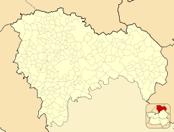
| Country | |
| Autonomous community | Castile-La Mancha |
| Province | Guadalajara |
| Comarca | Señorío de Molina-Alto Tajo |
| Area | |
• Total | 44 km2 (17 sq mi) |
| Population (2024-01-01) [1] | |
• Total | 35 |
| • Density | 0.80/km2 (2.1/sq mi) |
| Time zone | UTC+1 (CET) |
| • Summer (DST) | UTC+2 (CEST) |
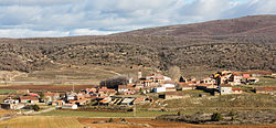
Selas is a municipality located in the province of Guadalajara, Castile-La Mancha, Spain. According to the 2004 census (INE), the municipality had a population of 63 inhabitants.
Contents
The Mesa River rises in the Sierra de Solorio range area near Selas. [2]