This article does not cite any sources . (October 2012) (Learn how and when to remove this template message) |
Torremochuela, Spain | |
---|---|
Coordinates: 40°46′01″N1°50′25″W / 40.76694°N 1.84028°W Coordinates: 40°46′01″N1°50′25″W / 40.76694°N 1.84028°W | |
Country | |
Autonomous community | Castile-La Mancha |
Province | Guadalajara |
Municipality | Torremochuela |
Area | |
• Total | 17 km2 (7 sq mi) |
Population (2018) [1] | |
• Total | 11 |
• Density | 0.65/km2 (1.7/sq mi) |
Time zone | UTC+1 (CET) |
• Summer (DST) | UTC+2 (CEST) |
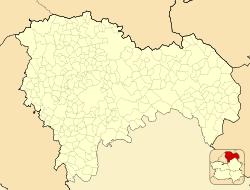
Torremochuela is a municipality located in the province of Guadalajara, Castile-La Mancha, Spain. According to the 2013 census (INE), the municipality has a population of 11 inhabitants.
A census is the procedure of systematically acquiring and recording information about the members of a given population. The term is used mostly in connection with national population and housing censuses; other common censuses include agriculture, business, and traffic censuses. The United Nations defines the essential features of population and housing censuses as "individual enumeration, universality within a defined territory, simultaneity and defined periodicity", and recommends that population censuses be taken at least every 10 years. United Nations recommendations also cover census topics to be collected, official definitions, classifications and other useful information to co-ordinate international practice.
The National Statistics Institute is the official agency in Spain that collects statistics about demography, economy, and Spanish society. It is an autonomous organization in Spain responsible for overall coordination of statistical services of the General State Administration in monitoring, control and supervision of technical procedures. Every 10 years, this organisation conducts a national census. The last census took place in 2011.
Wikimedia Commons has media related to Torremochuela . |
This article about a location in the autonomous community of Castilla–La Mancha, Spain is a stub. You can help Wikipedia by expanding it. |
El Maíllo is a village and municipality in the province of Salamanca, in the Autonomous Community of Castilla y Leon, Spain. It is situated some 72 km (45 mi) from Salamanca, the provincial capital. As of 2016 the municipality has a population of 287 inhabitants. The municipality has an area of 46 km2 (18 sq mi). It sits at 985 m (3,232 ft) above sea level. Its postal code is 37261.
El Tornadizo is a village and municipality in the province of Salamanca, western Spain, part of the autonomous community of Castile-Leon. It is located 61 kilometres (38 mi) from the provincial capital city of Salamanca and has a population of 88 people.
Ledrada is a municipality located in the province of Salamanca, Castile and León, Spain. As of 2016 the municipality has a population of 577 inhabitants.
Machacón is a municipality located in the province of Salamanca, Castile and León, Spain. As of 2016 the municipality has a population of 453 inhabitants.
Martiago is a municipality located in the province of Salamanca, Castile and León, Spain. As of 2016 the municipality has a population of 302 inhabitants. The municipality is known because of its flat lands favorable for wars. The origin of the name Martiago comes from "Marte" (mart) and "Terra" (Tiago) which means: "Tierra de Marte" or in other words, meaning that it was there where some wars happened.
Palaciosrubios is a municipality located in the province of Salamanca, Castile and León, Spain. As of 2016 the municipality has a population of 382 inhabitants.
Puebla de San Medel is a municipality located in the province of Salamanca, Castile and León, Spain. As of 2016 the municipality has a population of 44 inhabitants.
Puerto de Béjar is a municipality located in the province of Salamanca, Castile and León, Spain. As of 2016 the municipality has a population of 380 inhabitants.
Puerto Seguro is a municipality located in the province of Salamanca, Castile and León, Spain. As of 2016 the municipality has a population of 64 inhabitants.
La Sagrada is a municipality located in the province of Salamanca, Castile and León, Spain. As of 2016 the municipality has a population of 112 inhabitants.
Sanchotello is a municipality located in the province of Salamanca, Castile and León, Spain. As of 2016 the municipality has a population of 227 inhabitants.
Santibáñez de Béjar is a municipality located in the province of Salamanca, Castile and León, Spain. As of 2016 the municipality has a population of 493 inhabitants.
Sorihuela is a municipality located in the province of Salamanca, Castile and León, Spain. As of 2016 the municipality has a population of 263 inhabitants.
El Tejado is a municipality located in the province of Salamanca, Castile and León, Spain. As of 2016 the municipality has a population of 120 inhabitants.
Valdehijaderos is a municipality located in the province of Salamanca, Castile and León, Spain. As of 2016 the municipality has a population of 83 inhabitants.
Valdelacasa is a municipality located in the province of Salamanca, Castile and León, Spain. As of 2016 the municipality has a population of 242 inhabitants.
Valdelageve is a municipality located in the province of Salamanca, Castile and León, Spain. As of 2016 the municipality has a population of 81 inhabitants.
Vallejera de Riofrío is a municipality located in the province of Salamanca, Castile and León, Spain. As of 2016 the municipality has a population of 67 inhabitants.
Guijuelo is a municipality located in the province of Salamanca, Castile and León, Spain. As of 2016 the municipality has a population of 5630 inhabitants.
Molinillo is a municipality located in the province of Salamanca, Castile and León, Spain. As of 2016 the municipality has a population of 52 inhabitants.