
Suhl is a city in Thuringia, Germany, located SW of Erfurt, 110 kilometres NE of Würzburg and 130 kilometres N of Nuremberg. With its 37,000 inhabitants, it is the smallest of the six urban districts within Thuringia. Together with its northern neighbour-town Zella-Mehlis, Suhl forms the largest urban area in the Thuringian Forest with a population of 46,000. The region around Suhl is marked by up to 1,000-meter-high mountains, including Thuringia's highest peak, the Großer Beerberg, approximately 5 kilometres NE of the city centre.
Schmalkalden-Meiningen is a Landkreis in the southwest of Thuringia, Germany. Its neighboring districts are the districts Wartburgkreis, Gotha, Ilm-Kreis, the district-free city Suhl, the district Hildburghausen, the Bavarian district Rhön-Grabfeld, and the district Fulda in Hesse.
Wartburgkreis is a Kreis (district) in the west of Thuringia, Germany. Neighboring districts are the districts Unstrut-Hainich-Kreis, Gotha, Schmalkalden-Meiningen, and the districts Fulda, Hersfeld-Rotenburg and Werra-Meißner-Kreis in Hesse. The district has 30 municipalities, including Eisenach.

Meiningen is a town in the southern part of the state of Thuringia, Germany. It is located in the region of Franconia and has a population of around 26,000 (2024). Meiningen is the capital and the largest town of the Schmalkalden-Meiningen district. From 1680 to 1920, Meiningen was the capital of the Duchy of Saxe-Meiningen.

Münnerstadt is a town in the district of Bad Kissingen in Bavaria, Germany. It has a population of around 7,600.

Schemmerhofen is a municipality ("Gemeinde") in the district ("Landkreis") of Biberach in Baden-Württemberg, Germany. Schemmerhofen is located in the Upper Swabia region of Baden-Württemberg.

Schloss Altenstein is a schloss, or palace, upon a rocky hill on the south-western slope of the Thuringian Forest, not far from Eisenach, Thuringia, Germany. It was the summer residence of the Dukes of Saxe-Meiningen, and is surrounded by 160 hectares of English landscape garden, which contain, among other objects of interest, a cavern 300 metres long, through which flows a large and rapid stream.

Wasungen is a town in the Schmalkalden-Meiningen district, in Thuringia, Germany. It is situated on the river Werra, 11 km north of Meiningen. The former municipalities Hümpfershausen, Metzels, Oepfershausen, Unterkatz and Wahns were merged into Wasungen in January 2019.

The House of Henneberg was a medieval German comital family (Grafen) which from the 11th century onwards held large territories in the Duchy of Franconia. Their county was raised to a princely county in 1310.
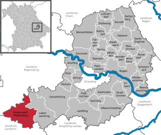
Mallersdorf-Pfaffenberg is a municipality in the district of Straubing-Bogen in Bavaria, Germany and has around 7,000 inhabitants.

Barchfeld is a village and a former municipality in the Wartburgkreis district of Thuringia, Germany. Since 31 December 2012, it is part of the municipality Barchfeld-Immelborn.

Nerzweiler is an Ortsgemeinde – a municipality belonging to a Verbandsgemeinde, a kind of collective municipality – in the Kusel district in Rhineland-Palatinate, Germany. It belongs to the Verbandsgemeinde Lauterecken-Wolfstein.

Mehren is an Ortsgemeinde – a municipality belonging to a Verbandsgemeinde, a kind of collective municipality – in the Vulkaneifel district in Rhineland-Palatinate, Germany. It belongs to the Verbandsgemeinde of Daun, whose seat is in the like-named town.

Strohn is an Ortsgemeinde – a municipality belonging to a Verbandsgemeinde, a kind of collective municipality – in the Vulkaneifel district in Rhineland-Palatinate, Germany. It belongs to the Verbandsgemeinde of Daun, whose seat is in the like-named town.
Hümpfershausen is a village and a former municipality in the district Schmalkalden-Meiningen, in Thuringia, Germany. Since 1 January 2019, it is part of the town Wasungen.

Oberweid is a municipality in the district Schmalkalden-Meiningen, in Thuringia, Germany. It is part of the Hohe Rhön administrative community, which has its administrative centre in the municipality of Kaltennordheim.
Oepfershausen is a village and a former municipality in the district Schmalkalden-Meiningen, in Thuringia, Germany. Since 1 January 2019, it is part of the town Wasungen.
Wahns is a village and a former municipality in the district Schmalkalden-Meiningen, in Thuringia, Germany. Since 1 January 2019, it is part of the town Wasungen.
Unterkatz is a village and a former municipality in the district Schmalkalden-Meiningen, in Thuringia, Germany. Since 1 January 2019, it is part of the town Wasungen.

Sonnefeld Abbey is a former Cistercian nunnery in Sonnefeld in Bavaria, Germany. The former abbey church, or Klosterkirche, is now an Evangelical Lutheran parish church.


