
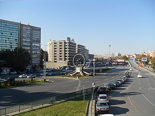
Mevlana Boulevard (also known as Konya Boulevard) is a boulevard in Ankara, Turkey. It is named after Mevlana, who is also known as Rumi, the Islamic scholar who spent most of his life in what is now Turkey in the 13th century.
Mevlana Boulevard (also known as Konya Boulevard) is a boulevard in Ankara, Turkey. It is named after Mevlana, who is also known as Rumi, the Islamic scholar who spent most of his life in what is now Turkey in the 13th century.
The boulevard was actually a part of the Ankara ring road before the construction of the motorway. The southernmost point of the boulevard is at 39°50′35″N32°48′21″E / 39.84306°N 32.80583°E where it fuses to ![]() D.750 the Turkish state highway which connects Ankara to South Turkey. The boulevard continues to North up to 39°57′04″N32°50′08″E / 39.95111°N 32.83556°E where it fuses to Turgut Özal Boulevard (which in turn fuses to
D.750 the Turkish state highway which connects Ankara to South Turkey. The boulevard continues to North up to 39°57′04″N32°50′08″E / 39.95111°N 32.83556°E where it fuses to Turgut Özal Boulevard (which in turn fuses to ![]() D.200 which connects Ankara to the east and north Turkey.) [1] Between these two points, the length of the boulevard is about 12.5 kilometres (7.8 mi).
D.200 which connects Ankara to the east and north Turkey.) [1] Between these two points, the length of the boulevard is about 12.5 kilometres (7.8 mi).
There are two important intersections. One is the intersection with İsmet İnönü Boulevard which connects Ankara to the west and the other one, at the end of the course is Fatih Sultan Mehmet Boulevard which connects Ankara to northwest Turkey. Most of the buildings are situated to the east of the boulevard. But new quarters of Ankara are flourishing to the west. One of the most important buildings is the intercity bus terminal of Ankara (AŞTİ). [2]

Ankara ), historically known as Ancyra and Angora, is the capital of Turkey. Located in the central part of Anatolia, the city has a population of 5.1 million in its urban center and 5.7 million in Ankara Province, making it Turkey's second-largest city after Istanbul, but first by the urban area (2,767 km2).

Sakarya is a province in Turkey, located on the coast of the Black Sea. The Sakarya River creates a webbing of estuaries in the province, which is in the Marmara Region. The adjacent provinces are Kocaeli to the west, Bilecik to the south, Bolu to the southeast and Düzce to the east. The capital of Sakarya is Adapazarı. Its climate is maritime in the north and humid subtropical in the south and changes by the distance to the Black Sea. Sakarya is on the Ankara-Istanbul highway and is also connected by rail. Sakarya is serviced by Istanbul's Sabiha Gökçen International Airport. The current mayor of Sakarya is Ekrem Yüce as of 2019. (AKP). The city of Sakarya, one of the most important cities in Turkey for its rapid growth and development, is also noteworthy for its natural beauties and its cultural richness. It is one of the paradise-like spots of the country with its sea, beaches, lakes, rivers, highlands, thermal springs, traditional Ottoman lifestyle districts such as Taraklı and Geyve and noteworthy historical relics that are inherited from the Byzantine and the Ottoman eras. The Turks conquered the city of Sakarya in the 13th century. There was intensive immigration from the Caucasus and the Balkans in the 18th and the 19th centuries. The last massive immigration was in 1989 from Bulgaria. The city has developed industry from being a transportation crossroads and still has inward domestic migration. Sakarya is notable in the Marmara Region. The city of Sakarya is surrounded with the city of Düzce in the east, Bolu in the south-east, Bilecik in the south, Kocaeli in the west and the Black Sea in the north. The city of Sakarya has 16 districts; Adapazarı, Akyazı, Arifiye, Erenler, Ferizli, Geyve, Hendek, Karapürçek, Karasu, Kaynarca, Kocaali, Pamukova, Sapanca, Serdivan, Söğütlü and Taraklı.

Etimesgut, formerly Ahimesut, is a municipality and metropolitan district of Ankara Province, Turkey. Its area is 273 km2, and its population is 614,891 (2022). It mainly consists of large public housing projects, 25 km (16 mi) from Ankara city centre. Its elevation is 843 m (2,766 ft).

Polatlı is a municipality and district of Ankara Province, Turkey. Its area is 3,618 km2, and its population is 128,378 (2022). It is 80 km west of the Turkish capital Ankara, on the road to Eskişehir. Its elevation is 853 m.
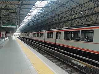
Ankaray, designated as the A1, is a 8.5 km (5.3 mi) long rapid transit line of the Ankara Metro system in Ankara, Turkey. Opened in 1996, it is the oldest rapid transit line in Ankara and the second oldest in Turkey after the M1 line of the Istanbul Metro. Ankaray begins at the Ankara Intercity Bus Terminal in southeastern Yenimahalle and runs east to Dikimevi in northeastern Çankaya and consists of 11 stations. In 2017, the line saw over 33.5 million boardings, making it the second busiest line of Ankara Metro, after the M1. Despite being a rapid transit line, the city of Ankara classifies Ankaray as a light-rail line.

Cahuenga Boulevard is a major boulevard of northern Los Angeles, California, US. The “Cahuenga” name is a Spanish, phonetic derivative with no actual Spanish language meaning that is attributed to the Tongva village of Kawengna, meaning "place of the mountain". It connects Sunset Boulevard in the heart of old Hollywood to the Hollywood Hills and North Hollywood in the San Fernando Valley.
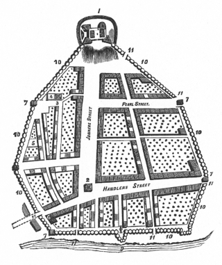
The streets of Albany, New York have had a long history going back almost 400 years. Many of the streets have changed names over the course of time, some have changed names many times. Some streets no longer exist, others have changed course. Some roads existed only on paper. The oldest streets were haphazardly laid out with no overall plan until Simeon De Witt's 1794 street grid plan. The plan had two grids, one west of Eagle Street and the old stockade, and another for the Pastures District south of the old stockade.
There are 9 routes assigned to the "N" zone of the California Route Marker Program, which designates county routes in California. The "N" zone includes county highways lying in Los Angeles and Orange counties.

July 15 Kızılay National Will Square, originally Kızılay Square, is one of the most important centers and junction points of Ankara, Turkey.
Sıhhıye Square is a square in Ankara, Turkey. "Sıhhiye" is a Turkish word for "Health". Because the former main building of the Ministry of Health was facing Sıhhiye Square from the east. Formerly, it was also called "Lausanne Square" referring to the city Lausanne in Switzerland where the Conference of Lausanne was held in 1922–1923
Atatürk Boulevard is the most important avenue in Ankara, Turkey.

Ulus Square is a square in Ankara, Turkey. "Ulus" is the Turkish word for "Nation".

Mehmetçik Monument is a monumental sculpture featuring a Turkish soldier on Kartaltepe of Polatlı, a rural area of Ankara Province, Turkey. The name of the monument Mehmetçik is the diminutive form of the common name Mehmet, which is used to nickname Turkish soldiers.
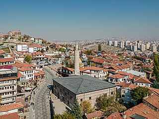
Aslanhane Mosque is a 13th-century mosque in Ankara, Turkey.

İsmet İnönü Boulevard is a busy boulevard in Ankara, Turkey. The boulevard is named after İsmet İnönü, the second president of Turkey and one of the pioneers of the Turkish War of Independence.

AŞTİ is the intercity bus terminal of Ankara, Turkey.

Maltepe Mosque is a mosque in Ankara, Turkey. Along with Kocatepe Mosque, it is one of the best known mosques in Ankara.

Ankara Aviation Museum is a military-based museum for aviation, owned and operated by the Turkish Air Force. The museum is located in Etimesgut district of Ankara, Turkey. The area of the museum is 64,321 m2 (692,350 sq ft).
Zafer Square is a square in Ankara, Turkey. Zafer means "victory". Although it is traditionally called square it is no longer a junction point.

AŞTİ is an underground station and the western terminus of the Ankaray line of the Ankara Metro in Çankaya. It is located on the east side of Mevlana Boulevard, across from the Ankara Intercity Bus Terminal (AŞTİ). AŞTİ station consists of two side platforms and opened on 30 August 1996, together with the Ankaray line. Connection to the bus terminal is available via a passageway underneath Mevlana Boulevard.
| Transportation | |
|---|---|
| Museums |
|
| Theatres | |
| Concert halls | |
| Libraries | |
| Sport venues | |
| High schools | |
| Universities Colleges | |
| Religious buildings | |
| Parks | |
| Streets Squares | |
| Others | |