
Seismology is the scientific study of earthquakes and the generation and propagation of elastic waves through the Earth or other planetary bodies. It also includes studies of earthquake environmental effects such as tsunamis as well as diverse seismic sources such as volcanic, tectonic, glacial, fluvial, oceanic microseism, atmospheric, and artificial processes such as explosions and human activities. A related field that uses geology to infer information regarding past earthquakes is paleoseismology. A recording of Earth motion as a function of time, created by a seismograph is called a seismogram. A seismologist is a scientist works in basic or applied seismology.

Geophysics is a subject of natural science concerned with the physical processes and physical properties of the Earth and its surrounding space environment, and the use of quantitative methods for their analysis. Geophysicists, who usually study geophysics, physics, or one of the Earth sciences at the graduate level, complete investigations across a wide range of scientific disciplines. The term geophysics classically refers to solid earth applications: Earth's shape; its gravitational, magnetic fields, and electromagnetic fields ; its internal structure and composition; its dynamics and their surface expression in plate tectonics, the generation of magmas, volcanism and rock formation. However, modern geophysics organizations and pure scientists use a broader definition that includes the water cycle including snow and ice; fluid dynamics of the oceans and the atmosphere; electricity and magnetism in the ionosphere and magnetosphere and solar-terrestrial physics; and analogous problems associated with the Moon and other planets.

A seismic wave is a mechanical wave of acoustic energy that travels through the Earth or another planetary body. It can result from an earthquake, volcanic eruption, magma movement, a large landslide and a large man-made explosion that produces low-frequency acoustic energy. Seismic waves are studied by seismologists, who record the waves using seismometers, hydrophones, or accelerometers. Seismic waves are distinguished from seismic noise, which is persistent low-amplitude vibration arising from a variety of natural and anthropogenic sources.

The Mohorovičić discontinuity – usually called the Moho discontinuity, Moho boundary, or just Moho – is the boundary between the crust and the mantle of Earth. It is defined by the distinct change in velocity of seismic waves as they pass through changing densities of rock.
Seismic tomography or seismotomography is a technique for imaging the subsurface of the Earth with seismic waves produced by earthquakes or explosions. P-, S-, and surface waves can be used for tomographic models of different resolutions based on seismic wavelength, wave source distance, and the seismograph array coverage. The data received at seismometers are used to solve an inverse problem, wherein the locations of reflection and refraction of the wave paths are determined. This solution can be used to create 3D images of velocity anomalies which may be interpreted as structural, thermal, or compositional variations. Geoscientists use these images to better understand core, mantle, and plate tectonic processes.
A P wave is one of the two main types of elastic body waves, called seismic waves in seismology. P waves travel faster than other seismic waves and hence are the first signal from an earthquake to arrive at any affected location or at a seismograph. P waves may be transmitted through gases, liquids, or solids.
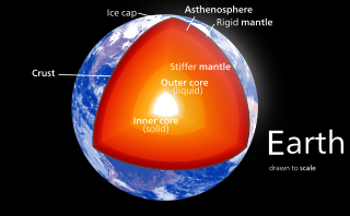
Earth's inner core is the innermost geologic layer of the planet Earth. It is primarily a solid ball with a radius of about 1,220 km (760 mi), which is about 20% of Earth’s radius or 70% of the Moon's radius.

Don Lynn Anderson was an American geophysicist who made significant contributions to the understanding of the origin, evolution, structure, and composition of Earth and other planets. An expert in numerous scientific disciplines, Anderson's work combined seismology, solid state physics, geochemistry and petrology to explain how the Earth works. Anderson was best known for his contributions to the understanding of the Earth's deep interior, and more recently, for the plate theory hypothesis that hotspots are the product of plate tectonics rather than narrow plumes emanating from the deep Earth. Anderson was Professor (Emeritus) of Geophysics in the Division of Geological and Planetary Sciences at the California Institute of Technology (Caltech). He received numerous awards from geophysical, geological and astronomical societies. In 1998 he was awarded the Crafoord Prize by the Royal Swedish Academy of Sciences along with Adam Dziewonski. Later that year, Anderson received the National Medal of Science. He held honorary doctorates from Rensselaer Polytechnic Institute and the University of Paris (Sorbonne), and served on numerous university advisory committees, including those at Harvard, Princeton, Yale, University of Chicago, Stanford, University of Paris, Purdue University, and Rice University. Anderson's wide-ranging research resulted in hundreds of published papers in the fields of planetary science, seismology, mineral physics, petrology, geochemistry, tectonics and the philosophy of science.
The EarthScope Consortium operates the Seismological Facility for the Advancement of Geoscience (SAGE) which manages some of the Global Seismographic Network stations and the Geodetic Facility for the Advancement of Geoscience (GAGE) which operates the Network of the Americas (NOTA). The EarthScope Consortium represents the merger of the former Incorporated Research Institutions for Seismology (IRIS) and UNAVCO efforts and continues a portion of the EarthScope project which concluded in March 2022.
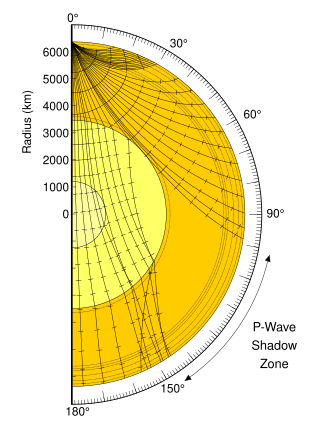
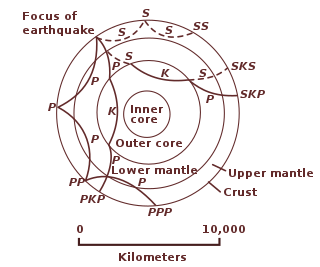
A seismic shadow zone is an area of the Earth's surface where seismographs cannot detect direct P waves and/or S waves from an earthquake. This is due to liquid layers or structures within the Earth's surface. The most recognized shadow zone is due to the core-mantle boundary where P waves are refracted and S waves are stopped at the liquid outer core; however, any liquid boundary or body can create a shadow zone. For example, magma reservoirs with a high enough percent melt can create seismic shadow zones.

Adam Marian Dziewoński was a Polish-American geophysicist who made seminal contributions to the determination of the large-scale structure of the Earth's interior and the nature of earthquakes using seismological methods. He spent most of his career at Harvard University, where he was the Frank B. Baird, Jr. Professor of Science.
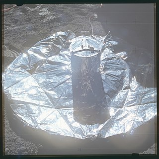
Lunar seismology is the study of ground motions of the Moon and the events, typically impacts or moonquakes, that excite them.
The following outline is provided as an overview of and topical guide to geophysics:
Hrvoje Tkalčić is Australian and Croatian scientist (geophysicist) and Professor E2 at the Australian National University in Canberra.

Inner core super-rotation is the eastward rotation of the inner core of Earth relative to its mantle, for a net rotation rate that is usually faster than Earth as a whole. A 1995 model of Earth's dynamo predicted super-rotations of up to 3 degrees per year; the following year, this prediction was supported by observed discrepancies in the time that p-waves take to travel through the inner and outer core.
Maureen D. Long is an observational seismologist studying mantle and Mesosphere dynamics. She currently serves as a professor at Yale University within the Department of Geology and Geophysics.
Miaki Ishii is a seismologist and Professor of Earth and Planetary Sciences at Harvard University.
Karen Fischer is an American seismologist known for her research on the structure of Earth's mantle, its lithosphere, and how subduction zones change over geologic history.
Annie Souriau is a French seismologist from the commune of Saint-Cloud Paris. She is primarily known for her research into Earth's inner and outer cores, specifically her work examining seismic activity within and around the Pyrenees mountains. Through her and her colleague's research and studies, she has made notable advances to how humans understand the inner workings of the Earth's core while also winning many awards in the process.

Seismic velocity structure is the distribution and variation of seismic wave speeds within Earth's and other planetary bodies' subsurface. It is reflective of subsurface properties such as material composition, density, porosity, and temperature. Geophysicists rely on the analysis and interpretation of the velocity structure to develop refined models of the subsurface geology, which are essential in resource exploration, earthquake seismology, and advancing our understanding of Earth's geological development.


