Related Research Articles
The geology of Hampshire in southern England broadly comprises a gently folded succession of sedimentary rocks dating from the Cretaceous and Palaeogene periods. The lower (early) Cretaceous rocks are sandstones and mudstones whilst those of the upper (late) Cretaceous are the various formations which comprise the Chalk Group and give rise to the county's downlands. Overlying these rocks are the less consolidated Palaeogene clays, sands, gravels and silts of the Lambeth, Thames and Bracklesham Groups which characterise the Hampshire Basin.

In structural geology, an anticline is a type of fold that is an arch-like shape and has its oldest beds at its core, whereas a syncline is the inverse of an anticline. A typical anticline is convex up in which the hinge or crest is the location where the curvature is greatest, and the limbs are the sides of the fold that dip away from the hinge. Anticlines can be recognized and differentiated from antiforms by a sequence of rock layers that become progressively older toward the center of the fold. Therefore, if age relationships between various rock strata are unknown, the term antiform should be used.
Compton and Shawford is a civil parish in the City of Winchester district, immediately southwest of the city, in Hampshire, England. Its main settlements are the villages of Compton and Shawford.
Beacon Hill, Warnford is a 46.4-hectare (115-acre) biological Site of Special Scientific Interest west of Warnford in Hampshire. It is a Nature Conservation Review site, and an area of 40.1 hectares is a national nature reserve. There is a round barrow cemetery dating to the Late Neolithic or Bronze Age on the hill, and this is a scheduled monument.

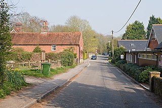
Chilcomb is a small village and civil parish in the English county of Hampshire 3 miles (4.8 km) east of Winchester and includes the South Downs Way long-distance footpath.
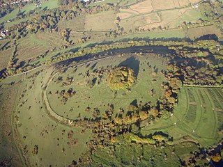
St. Catherine's Hill is a chalk downland hill and 43-hectare (110-acre) biological Site of Special Scientific Interest on the outskirts of Winchester in Hampshire. It is owned by Winchester College but open to the public. It is managed by Hampshire and Isle of Wight Wildlife Trust, and most of it is an Iron Age hillfort, which is a Scheduled Monument.

The London Basin is an elongated, roughly triangular sedimentary basin approximately 250 kilometres (160 mi) long which underlies London and a large area of south east England, south eastern East Anglia and the adjacent North Sea. The basin formed as a result of compressional tectonics related to the Alpine orogeny during the Palaeogene period and was mainly active between 40 and 60 million years ago.

The Hampshire Basin is a geological basin of Palaeogene age in southern England, underlying parts of Hampshire, the Isle of Wight, Dorset, and Sussex. Like the London Basin to the northeast, it is filled with sands and clays of Paleocene and younger ages and it is surrounded by a broken rim of chalk hills of Cretaceous age.
The Winchester-East Meon Anticline is one of a series of parallel east–west trending folds in the Cretaceous chalk of Hampshire. It lies at the western end of the South Downs, immediately to the north of the Hampshire Basin and south-east of Salisbury Plain.
The Winchester-King's Somborne Syncline is one of a series of parallel east-west trending folds in the Cretaceous chalk of Hampshire. It lies at the western end of the South Downs, immediately to the north of the Winchester-East Meon Anticline and east of Salisbury Plain.
The Stockbridge Anticline is one of a series of parallel east-west trending folds in the Cretaceous chalk of Hampshire. It lies at the western end of the South Downs, immediately to the north of the Winchester-King's Somborne Syncline and east of Salisbury Plain.
The Dean Hill Anticline is an east-west trending fold in the Cretaceous chalk of Hampshire, England. It lies immediately to the north of the Hampshire Basin and south of Salisbury Plain.
The Alderbury-Mottisfont Syncline is an east–west trending fold in the Cretaceous chalk of Hampshire. It lies to the north of the Dean Hill Anticline and south of Salisbury Plain.
The geology of West Sussex in southeast England comprises a succession of sedimentary rocks of Cretaceous age overlain in the south by sediments of Palaeogene age. The sequence of strata from both periods consists of a variety of sandstones, mudstones, siltstones and limestones. These sediments were deposited within the Hampshire and Weald basins. Erosion subsequent to large scale but gentle folding associated with the Alpine Orogeny has resulted in the present outcrop pattern across the county, dominated by the north facing chalk scarp of the South Downs. The bedrock is overlain by a suite of Quaternary deposits of varied origin. Parts of both the bedrock and these superficial deposits have been worked for a variety of minerals for use in construction, industry and agriculture.
The Portsdown Anticline is a north-facing geological fold of Tertiary age affecting rocks in Hampshire, southern England. This upfold of the local sedimentary rock sequence is paralleled by the Bere Forest/Chichester Syncline (downfold) about 2km to its north and a postulated deep fault to the north again. Further west, this major east-west structure adopts more of a NW - SE alignment. At the surface the Portsdown Anticline is seen to affect the Chalk rocks of Late Cretaceous age at Ports Down though it is known to also affect the underlying Jurassic strata.

The Exmoor Group is a late Devonian to early Carboniferous lithostratigraphic group in southwest England whose outcrop extends from Croyde in north Devon east across Exmoor to Minehead in west Somerset. The group comprises the following formations the:
The geology of the Gower Peninsula in South Wales is central to the area's character and to its appeal to visitors. The peninsula is formed almost entirely from a faulted and folded sequence of Carboniferous rocks though both the earlier Old Red Sandstone and later New Red Sandstone are also present. Gower lay on the southern margin of the last ice sheet and has been a focus of interest for researchers and students in that respect too. Cave development and the use of some for early human occupation is a further significant aspect of the peninsula's scientific and cultural interest.
The geology of the Peak District National Park in England is dominated by a thick succession of faulted and folded sedimentary rocks of Carboniferous age. The Peak District is often divided into a southerly White Peak where Carboniferous Limestone outcrops and a northerly Dark Peak where the overlying succession of sandstones and mudstones dominate the landscape. The scarp and dip slope landscape which characterises the Dark Peak also extends along the eastern and western margins of the park. Although older rocks are present at depth, the oldest rocks which are to be found at the surface in the national park are dolomitic limestones of the Woo Dale Limestone Formation seen where Woo Dale enters Wye Dale east of Buxton.
The geology of the South Downs National Park in South East England comprises a gently folded succession of sedimentary rocks from the Cretaceous and early Palaeogene periods overlain in places by a range of superficial deposits from the last 2.6 million years. Whereas the South Downs are formed from the Late Cretaceous age chalk, the South Downs National Park extends into the Weald to the north of the range and thereby includes older rock strata dating from the Early Cretaceous including sandstones and mudstones. The youngest solid rocks are found on the southern fringes of the National Park in the eastern extension of the Hampshire Basin and include sand, silt and clay deposited during the Palaeocene and Eocene epochs.
References
- ↑ Andover (Map). 1:50000. British Geological Survey England and Wales. British Geological Survey. 2012. ISBN 978-0-7518-3655-4.
- ↑ Winchester (Map). 1:50000. British Geological Survey England and Wales. British Geological Survey. 2002. ISBN 0-7518-3340-1.
- ↑ Alresford (Map). 1:50000. British Geological Survey England and Wales. British Geological Survey. 1999. ISBN 0-7518-3250-2.
- ↑ Booth, K.A. (2002). Geology of the Winchester district - a brief explanation of the geological map. British Geological Survey. ISBN 0-85272-429-2.
| | This article about a specific United Kingdom geological feature is a stub. You can help Wikipedia by expanding it. |