Stockbridge Anticline

Last updated

The Stockbridge Anticline is one of a series of parallel east-west trending folds in the Cretaceous chalk of Hampshire. It lies at the western end of the South Downs, immediately to the north of the Winchester-King's Somborne Syncline and east of Salisbury Plain.

Fold (geology) fold in geology

A geological fold occurs when one or a stack of originally flat and planar surfaces, such as sedimentary strata, are bent or curved as a result of permanent deformation. Synsedimentary folds are those due to slumping of sedimentary material before it is lithified. Folds in rocks vary in size from microscopic crinkles to mountain-sized folds. They occur singly as isolated folds and in extensive fold trains of different sizes, on a variety of scales.

Cretaceous third and last period of the Mesozoic Era

The Cretaceous is a geologic period and system that spans 79 million years from the end of the Jurassic Period 145 million years ago (mya) to the beginning of the Paleogene Period 66 mya. It is the last period of the Mesozoic Era, and the longest period of the Phanerozoic Eon. The Cretaceous Period is usually abbreviated K, for its German translation Kreide.

Chalk A soft, white, porous sedimentary rock made of calcium carbonate

Chalk is a soft, white, porous, sedimentary carbonate rock, a form of limestone composed of the mineral calcite. Calcite is an ionic salt called calcium carbonate or CaCO3. It forms under reasonably deep marine conditions from the gradual accumulation of minute calcite shells (coccoliths) shed from micro-organisms called coccolithophores. Flint (a type of chert) is very common as bands parallel to the bedding or as nodules embedded in chalk. It is probably derived from sponge spicules or other siliceous organisms as water is expelled upwards during compaction. Flint is often deposited around larger fossils such as Echinoidea which may be silicified (i.e. replaced molecule by molecule by flint).

Contents

Structure

The anticline axis runs for around 35 kilometres (22 mi) from around the Wallops, swinging south-south-east through Stockbridge and Crawley, between Micheldever and Kings Worthy, towards Medstead in the east. [1] [2]

Anticline geological term

In structural geology, an anticline is a type of fold that is an arch-like shape and has its oldest beds at its core. A typical anticline is convex up in which the hinge or crest is the location where the curvature is greatest, and the limbs are the sides of the fold that dip away from the hinge. Anticlines can be recognized and differentiated from antiforms by a sequence of rock layers that become progressively older toward the center of the fold. Therefore, if age relationships between various rock strata are unknown, the term antiform should be used.

Nether Wallop village in United Kingdom

Nether Wallop is a village and civil parish in the Test Valley district of Hampshire, England. It is located approximately 3.7 miles (6 km) northwest of Stockbridge, and approximately 7 miles (11 km) southwest of Andover.

Stockbridge, Hampshire town and civil parish in west Hampshire, England

Stockbridge is a small town and civil parish in the Test Valley district of Hampshire, England. It is one of the smallest towns in the United Kingdom with a population of 592 as of the 2011 census. It sits astride the River Test and at the foot of Stockbridge Down.

Hills include Danebury and Chattis Hill to the west, Stockbridge Down, Woolbury, Chilbolton Down, Windmill Hill (Crawley) and Abbotstone Down.

Danebury hillfort in Hampshire

Danebury is an Iron Age hill fort in Hampshire in England, about 19 kilometres (12 mi) north-west of Winchester. The site, covering 5 hectares, was excavated by Barry Cunliffe in the 1970s. Danebury is considered a type-site for hill forts, and was important in developing the understanding of hill forts, as very few others have been so intensively excavated.

Chattis Hill human settlement in United Kingdom

Chattis Hill is a hamlet in the Test Valley district of Hampshire, England. The village lies approximately 2 miles (3.3 km) west from Stockbridge, which both lie on the A30 road. At the 2011 Census the Post Office indicates that the population of the hamlet was included in the civil parish of Broughton.

Woolbury

Woolbury, or Woolbury Ring, is the site of an Iron Age univallate hill fort on Stockbridge Down, Hampshire, England.

Parallel folds to the south include the Winchester-East Meon Anticline and the Winchester-King's Somborne Syncline. To the north is the Micheldever Syncline. As with other nearby folds, the structure is controlled by movement of fault blocks within the Jurassic strata below. [3]

The Winchester-East Meon Anticline is one of a series of parallel east-west trending folds in the Cretaceous chalk of Hampshire. It lies at the western end of the South Downs, immediately to the north of the Hampshire Basin and south-east of Salisbury Plain.

The Micheldever Syncline is one of a series of parallel east-west trending folds in the Cretaceous chalk of Hampshire. It lies at the western end of the South Downs, immediately to the north of the Stockbridge Anticline and east of Salisbury Plain.

The Jurassic was a geologic period and system that spanned 56 million years from the end of the Triassic Period 201.3 million years ago (Mya) to the beginning of the Cretaceous Period 145 Mya. The Jurassic constitutes the middle period of the Mesozoic Era, also known as the Age of Reptiles. The start of the period was marked by the major Triassic–Jurassic extinction event. Two other extinction events occurred during the period: the Pliensbachian-Toarcian extinction in the Early Jurassic, and the Tithonian event at the end; however, neither event ranks among the "Big Five" mass extinctions.

See also

List of geological folds in Great Britain

Related Research Articles

The geology of Hampshire in southern England broadly comprises a gently folded succession of sedimentary rocks dating from the Cretaceous and Palaeogene periods. The lower (early) Cretaceous rocks are sandstones and mudstones whilst those of the upper (late) Cretaceous are the various formations which comprise the Chalk Group and give rise to the county's downlands. Overlying these rocks are the less consolidated Palaeogene clays, sands, gravels and silts of the Lambeth, Thames and Bracklesham Groups which characterise the Hampshire Basin.

Michelmersh village in United Kingdom

Michelmersh is a small, scattered village in Hampshire, England some three miles (4.8 km) north of Romsey.

Fair Oak village in the United Kingdom

Fair Oak, Hampshire is a large village on the outskirts of Eastleigh, and near Southampton and Winchester. Its parish incorporates the neighbouring village of Horton Heath, which lies to the south.

Owslebury village in the United Kingdom

Owslebury is a village and civil parish in the county of Hampshire, in the south of England approximately 5 miles (8.0 km) outside Winchester. It lies within the administrative district of the City of Winchester.

Compton and Shawford civil parish in the City of Winchester, Hampshire, England

Compton and Shawford is a civil parish in the City of Winchester, Hampshire, England. The word compton means village in a combe and aptly describes the settlement as it primarily consists of a long street on the side of a chalk valley.

Beacon Hill, Warnford, Hampshire is a chalk hill in the South Downs on the boundary of the parishes of Warnford and Exton. Part of the hill is a national nature reserve and 44.8 hectares biological SSSI, first notified in 1979.

Chilcomb village in the United Kingdom

Chilcomb is a small village and civil parish in the English county of Hampshire 3 miles (4.8 km) east of Winchester and includes the South Downs Way long distance footpath.

St. Catherines Hill, Hampshire hillfort in Hampshire

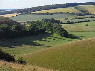
St. Catherine's Hill is a small but dramatic chalk hill to the south east of Winchester in Hampshire, England. Rising steeply some 67 metres (220 ft) from the water meadows of the River Itchen, the summit of the hill at 97 metres (318 ft) provides a fine view over Winchester.

Hampshire Basin

The Hampshire Basin is a geological basin of Palaeogene age in southern England, underlying parts of Hampshire, the Isle of Wight, Dorset, and Sussex. Like the London Basin to the northeast, it is filled with sands and clays of Paleocene and younger ages and it is surrounded by a broken rim of chalk hills of Cretaceous age.

Henwood Down

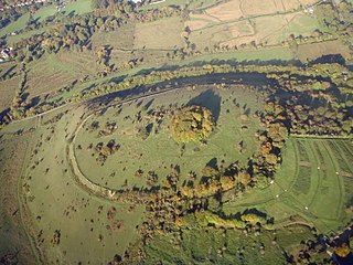
Henwood Down is one of the highest points in the county of Hampshire, England, and in the South Downs, reaching a height of 201 metres (659 ft) above sea level. Its prominence of 64 metres qualifies it as a Tump.

The Winchester-King's Somborne Syncline is one of a series of parallel east-west trending folds in the Cretaceous chalk of Hampshire. It lies at the western end of the South Downs, immediately to the north of the Winchester-East Meon Anticline and east of Salisbury Plain.

The Dean Hill Anticline is an east-west trending fold in the Cretaceous chalk of Hampshire. It lies immediately to the north of the Hampshire Basin and south of Salisbury Plain.

The Alderbury-Mottisfont Syncline is an east-west trending fold in the Cretaceous chalk of Hampshire. It lies to the north of the Dean Hill Anticline and south of Salisbury Plain.

The geology of West Sussex in southeast England comprises a succession of sedimentary rocks of Cretaceous age overlain in the south by sediments of Palaeogene age. The sequence of strata from both periods consists of a variety of sandstones, mudstones, siltstones and limestones. These sediments were deposited within the Hampshire and Weald basins. Erosion subsequent to large scale but gentle folding associated with the Alpine Orogeny has resulted in the present outcrop pattern across the county, dominated by the north facing chalk scarp of the South Downs. The bedrock is overlain by a suite of Quaternary deposits of varied origin. Parts of both the bedrock and these superficial deposits have been worked for a variety of minerals for use in construction, industry and agriculture.

The Portsdown Anticline is a north-facing geological fold of Tertiary age affecting rocks in Hampshire, southern England. This upfold of the local sedimentary rock sequence is paralleled by the Bere Forest/Chichester Syncline (downfold) about 2km to its north and a postulated deep fault to the north again. Further west, this major east-west structure adopts more of a NW - SE alignment. At the surface the Portsdown Anticline is seen to affect the Chalk rocks of Late Cretaceous age at Ports Down though it is known to also affect the underlying Jurassic strata.

Exmoor Group

The Exmoor Group is a late Devonian to early Carboniferous lithostratigraphic group in southwest England whose outcrop extends from Croyde in north Devon east across Exmoor to Minehead in west Somerset. The group comprises the following formations the:

References

  1. Winchester (Map). 1:50000. British Geological Survey England and Wales. British Geological Survey. 2002. ISBN   0-7518-3340-1.
  2. Alresford (Map). 1:50000. British Geological Survey England and Wales. British Geological Survey. 1999. ISBN   0-7518-3250-2.
  3. Booth, K.A. (2002). Geology of the Winchester district - a brief explanation of the geological map. British Geological Survey. ISBN   0-85272-429-2.