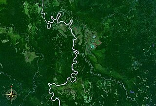
Sogeram River is a river in Madang Province, Papua New Guinea. It empties into the Ramu River at 4.8°S 144.7333333°E.
The Monumbo or Bogia languages are a pair of closely related languages that constitute a branch of the Torricelli language family. They are spoken in a few coastal villages of Bogia District, Madang Province in Papua New Guinea.
The Ottilien languages are a small family of clearly related languages,
Benabena is a stretch of valley that extends to the east of Goroka town in the west and borders with the Upper Ramu area of the Madang Province to the north, the Ungaii District to its south and the Henganofi District to its east. The name "Bena Bena' derived from a small hamlet or village just a few kilometres away from the once small rural station of Sigerehi in the Upper Bena area in the Eastern Highlands of Papua New Guinea. The Bena Bena Valley had once known for a centre for weaving. The town was known also as Bena Bena.

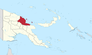
Bogia District is a district in the north-west of Madang Province in Papua New Guinea. It is one of the six administrative districts that make up the province.
Madang District is a district in the central part of Madang Province in Papua New Guinea. It is one of the six administrative districts that make up the province.
Rai Coast District is a district in the southeast of Madang Province in Papua New Guinea. It is one of the six administrative districts that make up the province. Many Rai Coast languages are spoken in this district.
The Middle Ramu or Annaberg languages are a small language family of Madang Province, Papua New Guinea. It is no longer accepted as a valid grouping by Glottolog, but is accepted by Foley (2018).
The Lower Ramu or Ottilien–Misegian languages consist of two branches in the Ramu language family. They are all spoken in Yawar Rural LLG, Madang Province, Papua New Guinea.
Aruamu a.k.a. Mikarew, also Ariawiai (Mikarew-Ariaw), is a Ramu language Mikarew village of Yawar Rural LLG, Madang Province, Papua New Guinea.
Mbore a.k.a. Gamei (Gamai) is a Ramu language of Papua New Guinea. It is spoken in Gamei and Boroi villages in Yawar Rural LLG, Bogia District, Madang Province.
Bosman is a Ramu language of Papua New Guinea. It is spoken five villages of Dongan ward, Yawar Rural LLG, Madang Province.
Marangis a.k.a. Watam is a Ramu language of Papua New Guinea. Like Bosmun, it shares a number of irregular plural markers with the Lower Sepik languages, supporting the proposal of a Ramu – Lower Sepik language family.
Kire (Giri) is a Ramu language of Giri village in Yawar Rural LLG, Madang Province, Papua New Guinea.
Dumpu is a village in the upper Ramu Valley in Madang Province, Papua New Guinea. The village was serviced by Dumpu Airport. During World War II the village became the divisional headquarters of the Australian 11th Division.
Gorovu is a nearly extinct Ramu language of Papua New Guinea.
Kaian (Kayan) is a Ramu language of Kaian village in Yawar Rural LLG, Madang Province, Papua New Guinea.
Awar is a Ramu language spoken in three villages in Yawar Rural LLG, Madang Province, Papua New Guinea.
Akrukay is a Ramu language of Papua New Guinea. It is spoken in the two villages of Akrurai and Andamang in Akrurai ward, Arabaka Rural LLG, Madang Province.