Kabenau River is a river in Madang Province, Papua New Guinea. It is located at about 5.466667°S 145.85°E. It was discovered in 1887 by geologist C. Schneider and explored in 1888 by Hugo Zöller. It flows westward and empties near Rimba to the Astrolabe Bay.

Astrolabe Bay is a large body of water off the south coast of Madang Province, Papua New Guinea, located at 5.35°S 145.9166667°E. It is a part of the Bismarck Sea and stretches from the Cape Iris in the south to the Cape Croisilles to the north. It was discovered in 1827 by Jules Dumont d'Urville and named after his ship. Capital of Madang Province, Madang lies on the coast of Astrolabe Bay.
The Gogol River is a river in Madang Province, Papua New Guinea. It empties to Astrolabe Bay at 5.316667°S 145.75°E.

Malas River is a river in Madang Province, Papua New Guinea. It rises in the Adelbert Range and empties to the Bismarck Sea at 4.6666667°S 145.5833333°E.

The Roman Catholic Archdiocese of Madang is a Metropolitan Archdiocese in Papua New Guinea with suffragan dioceses of Aitape, Lae, Vanimo and Wewak.

Daulo District is part of the Eastern Highlands Province in Papua New Guinea. It is along the Highlands highway leading to the other Highlands provinces, namely Simbu Province, Western Highlands, Southern Highlands and Enga Province. Daulo District shares geographical border with Simbu Province and Madang Province. Part of Daulo District's Upper Asaro Constituency is a walking distance to Mt. Wilhelm, Papua New Guinea's highest mountain in Simbu Province. Daulo is the real home of the famous Asaro Mudmen. It has a total population of over 45,000 people. It has a small district office administered by the District Administrator who is a representative of the provincial government. The electoral member for Daulo, with the help of the governor for the province, is responsible for the set up and running of Daulo District similarly with the other districts in the Eastern Highlands Province. The district was partly the implementation of the reform initiative undertaken by the Morauta government in 1995.
Bogia District is a district in the north-west of Madang Province in Papua New Guinea. It is one of the six administrative districts that make up the province.
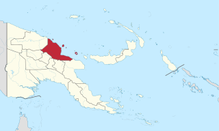
Madang District is a district in the central part of Madang Province in Papua New Guinea. It is one of the six administrative districts that make up the province.
Middle Ramu District is a district in the south-west of Madang Province in Papua New Guinea. It is one of the six administrative districts that make up the province.
Rai Coast District is a district in the southeast of Madang Province in Papua New Guinea. It is one of the six administrative districts that make up the province. Many Rai Coast languages are spoken in this district.
Sumkar District is a district in the north of Madang Province in Papua New Guinea. It is one of the six administrative districts that make up the province. Sumkar is a district which is made up of Karkar Island and part of mainland NCR.
Brem (Barem), also known as Bunabun, is a Papuan language of Sumgilbar Rural LLG, Madang Province, Papua New Guinea.
Lilau is a Papuan language of Papua New Guinea, closely related to Monumbo. It is spoken in Lilau ward, Almami Rural LLG, Bogia District, Madang Province.
Dumpu is a village in the upper Ramu Valley in Madang Province, Papua New Guinea. The village was serviced by Dumpu Airport. During World War II the village became the divisional headquarters of the Australian 11th Division.
Gorovu is a nearly extinct Ramu language of Papua New Guinea.
Manep is a Papuan language of Sumgilbar Rural LLG, Madang Province, Papua New Guinea.
Saidor is a village located in Madang Province, on the north coast of Papua New Guinea. Saidor is also the administrative centre of the Rai Coast District of Madang Province in Papua New Guinea.

Glossodoris buko is a species of sea slug, a dorid nudibranch, a shell-less marine gastropod mollusk in the family Chromodorididae.
Yamben is a Trans–New Guinea language of Madang Province, Papua New Guinea. It was first documented by Andrew Pick in the 2010s and classified by Pick (2019) as a probable primary branch of Madang, though its precise classification is still pending further research. Although surrounded by Croisilles languages, Yamben is not one of them.