North Bend is a city in King County, Washington, United States on the outskirts of the Seattle, Washington metropolitan area. The population was 6,739 in a 2016 census estimate.

Snoqualmie is a city next to Snoqualmie Falls in King County, Washington. It is twenty-five miles east of Seattle. This city is home to the Northwest Railway Museum. The population was 13,190 in a 2016 census estimate.

Snoqualmie Falls is a 268-foot (82 m) waterfall in the northwest United States, located east of Seattle on the Snoqualmie River between Snoqualmie and Fall City, Washington. It is one of Washington's most popular scenic attractions, but is perhaps best known internationally for its appearance in the cult television series Twin Peaks. More than 1.5 million visitors come to the Falls every year, where there is a two-acre park, an observation deck, and a gift shop.

Shivanasamudra is a small city in the Mandya District of the state of Karnataka, India. It is situated on the banks of the river Kaveri, which forms here the boundary to the Chamarajanagar District, and is the location of one of the first hydro-electric power stations in Asia, which was set up in 1902.The project was designed by Diwan Sheshadri Iyer.

Iron Horse State Park, part of the Washington State Park System, is a 1,612-acre (7 km2) state park located in the Cascade Mountains and Yakima River Valley, between Cedar Falls on the west and the Columbia River on the east.

Fantastic Falls is a waterfall on the North fork of the Snoqualmie River in the U.S. state of Washington. At 35 ft, is the largest of several small waterfalls in the Ernie's Grove area.
Kanim Falls (200 ft) is the major waterfall on the North Fork of the Snoqualmie River. It is located at the outlet of Kanim Lake and is near the source of the North Fork of the Snoqualmie River.
Nellie Falls is a waterfall on the Middle Fork of the Snoqualmie River in Washington, in the United States.

Weeks Falls is a waterfall on the South fork of the Snoqualmie River, located just south of Interstate 90 at exit 38. The falls are at the end of the road that goes past the Olallie State Park ranger headquarters. From the gravel parking lot, there is a paved accessible overlook to see the falls and a small area around the hydro-electric plant. Also, there is a 1/4 mile accessible interpretive trail nearby.
Upper Weeks Falls is a waterfall on the South fork of the Snoqualmie River. It is located south of Interstate 90
Denny Camp Falls is a 25-foot waterfall on the South Fork of the Snoqualmie River.

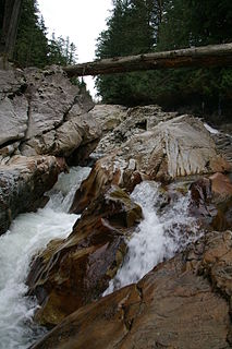
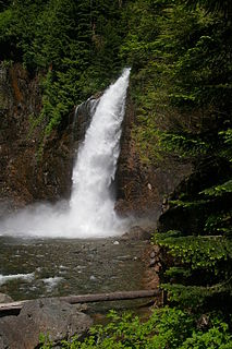
Franklin Falls is a waterfall on the South fork of the Snoqualmie River, the first of three major waterfalls on the South Fork Snoqualmie River. The falls are located near Snoqualmie Pass in King County, Washington, United States, between the north and south lanes of Interstate 90, just east of exit 47. The falls actually consist of three tiers, totaling about 135 feet (41 m). The first drop is a very scenic 15-foot (4.6 m) block-shaped fall. The second drop is a 25-foot (7.6 m) fanning cascade. The final drop begins as a 25-foot slide, which bends to the right, then plunges over the final 70-foot (21 m) drop seen from the base of the falls. The falls are popular canyoneering destination. The upper two drops are north of the freeway.

Bridal Veil Falls is a 1,328-foot (405 m) waterfall that flows from Lake Serene directly to the South Fork Skykomish River on the creek of the same name in the U.S. state of Washington. It is a perennial 150-foot (46 m) wide drop with four tiers, two of which are clearly visible. It is at 47.78950°N 121.56924°W.
The Taylor River is a river in King County in Washington.
Snoqualmie Lake is a lake in King County, Washington. It is an expansion of the Taylor River and is located a short distance downstream from Deer Lake. It is the largest of the three lakes along the upper reaches of the Taylor.


