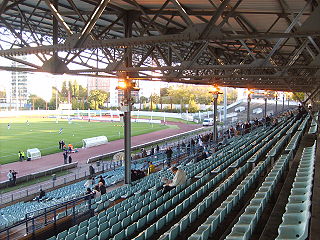
The Stade Olympique Yves-du-Manoir is a rugby, track and association football stadium in Colombes, near Paris, France.
Mill Brook is a 10.7-mile-long (17.2 km) stream located in the White Mountains of New Hampshire in the United States. It is a tributary of the southern Swift River, part of the Bearcamp River / Ossipee Lake / Saco River watershed leading to the Atlantic Ocean.

Asyrmatos is a neighbourhood in the city of Patras, Achaea, Greece.
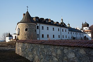
Krekhiv is a village in the Lviv Oblast (Province) of Ukraine, located within the densely forested Roztochia Upland about 10 km west of Zhovkva and 50 km north of Lviv at around 50°2′56″N23°48′43″E. The village is famous for its Basilian monastery which is a popular pilgrimage site.

Jadwigowo is a village in the administrative district of Gmina Mrocza, within Nakło County, Kuyavian-Pomeranian Voivodeship, in north-central Poland. It lies approximately 4 kilometres (2 mi) west of Mrocza, 13 km (8 mi) north of Nakło nad Notecią, and 34 km (21 mi) north-west of Bydgoszcz.
Orlinek is a village in the administrative district of Gmina Mrocza, within Nakło County, Kuyavian-Pomeranian Voivodeship, in north-central Poland. It lies approximately 4 kilometres (2 mi) west of Mrocza, 13 km (8 mi) north of Nakło nad Notecią, and 34 km (21 mi) north-west of Bydgoszcz.
Leopoldów is a village in the administrative district of Gmina Trzeszczany, within Hrubieszów County, Lublin Voivodeship, in eastern Poland. It lies approximately 8 kilometres (5 mi) west of Hrubieszów and 98 km (61 mi) south-east of the regional capital Lublin.
Hilarów is a settlement in the administrative district of Gmina Zadzim, within Poddębice County, Łódź Voivodeship, in central Poland.
Trzonów is a village in the administrative district of Gmina Książ Wielki, within Miechów County, Lesser Poland Voivodeship, in southern Poland. It lies approximately 8 kilometres (5 mi) east of Książ Wielki, 18 km (11 mi) north-east of Miechów, and 47 km (29 mi) north-east of the regional capital Kraków.
Smyków is a village in the administrative district of Gmina Daleszyce, within Kielce County, Świętokrzyskie Voivodeship, in south-central Poland. It lies approximately 6 kilometres (4 mi) east of Daleszyce and 20 km (12 mi) south-east of the regional capital Kielce.
Bogdany Wielkie is a village in the administrative district of Gmina Chorzele, within Przasnysz County, Masovian Voivodeship, in east-central Poland.

Qian County or Qianxian is a county under the administration of the prefecture-level city of Xianyang, in the central part of Shaanxi province, China.
Zdroje is a settlement in the administrative district of Gmina Łobżenica, within Piła County, Greater Poland Voivodeship, in west-central Poland. It lies approximately 11 kilometres (7 mi) east of Łobżenica, 47 km (29 mi) east of Piła, and 100 km (62 mi) north of the regional capital Poznań.
Borki is a village in the administrative district of Gmina Słupca, within Słupca County, Greater Poland Voivodeship, in west-central Poland.
Ciemnice is a village in the administrative district of Gmina Dąbie, within Krosno Odrzańskie County, Lubusz Voivodeship, in western Poland. It lies approximately 7 kilometres (4 mi) east of Dąbie, 11 km (7 mi) east of Krosno Odrzańskie, and 21 km (13 mi) north-west of Zielona Góra.
Bolesławowo is a village in the administrative district of Gmina Debrzno, within Człuchów County, Pomeranian Voivodeship, in northern Poland. It lies approximately 4 kilometres (2 mi) north of Debrzno, 13 km (8 mi) south-west of Człuchów, and 128 km (80 mi) south-west of the regional capital Gdańsk.
Brzeźno is a village in the administrative district of Gmina Szczecinek, within Szczecinek County, West Pomeranian Voivodeship, in north-western Poland.

Camp Pardee is an unincorporated East Bay MUD company town for the operators of Pardee Dam. It is located in Calaveras County, California, near Pardee Reservoir. It lies at an elevation of 696 feet and is home to 35 people.
Xiangshan District is a district of the city of Huaibei, Anhui Province, China.
Campo Largo do Piauí is a municipality in the state of Piauí in the Northeast region of Brazil.