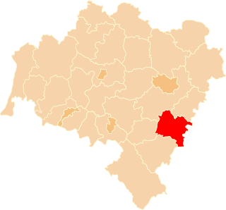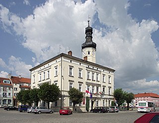
Wiązów is a town in Strzelin County, Lower Silesian Voivodeship, in south-western Poland. It is the seat of the administrative district (gmina) called Gmina Wiązów. The town lies approximately 11 kilometres (7 mi) east of Strzelin, and 37 kilometres (23 mi) south of the regional capital Wrocław.

Piotrowice is a village in the administrative district of Gmina Strzelin, within Strzelin County, Lower Silesian Voivodeship, in south-western Poland. Prior to 1945 it was in Germany. It lies approximately 5 kilometres (3 mi) west of Strzelin and 39 km (24 mi) south of the regional capital Wrocław.
Pławna is a village in the administrative district of Gmina Strzelin, within Strzelin County, Lower Silesian Voivodeship, in south-western Poland. Prior to 1945 it was in Germany. It lies approximately 7 kilometres (4 mi) north-east of Strzelin and 33 km (21 mi) south of the regional capital Wrocław.
Bryłów is a village in the administrative district of Gmina Wiązów, within Strzelin County, Lower Silesian Voivodeship, in south-western Poland.
Bryłówek is a village in the administrative district of Gmina Wiązów, within Strzelin County, Lower Silesian Voivodeship, in south-western Poland.
Częstocice is a village in the administrative district of Gmina Wiązów, within Strzelin County, Lower Silesian Voivodeship, in south-western Poland.
Gułów is a village in the administrative district of Gmina Wiązów, within Strzelin County, Lower Silesian Voivodeship, in south-western Poland. It lies approximately 3 kilometres (2 mi) north-west of Wiązów, 10 kilometres (6 mi) north-east of Strzelin, and 34 kilometres (21 mi) south of the regional capital Wrocław.
Janowo is a village in the administrative district of Gmina Wiązów, within Strzelin County, Lower Silesian Voivodeship, in south-western Poland. Prior to 1945 it was in Germany.
Jutrzyna is a village in the administrative district of Gmina Wiązów, within Strzelin County, Lower Silesian Voivodeship, in south-western Poland. Prior to 1945 it was in Germany.
Kalinowa is a village in the administrative district of Gmina Wiązów, within Strzelin County, Lower Silesian Voivodeship, in south-western Poland. Prior to 1945 it was in Germany.
Kowalów is a village in the administrative district of Gmina Wiązów, within Strzelin County, Lower Silesian Voivodeship, in south-western Poland. Prior to 1945 it was in Germany. It lies approximately 7 kilometres (4 mi) south of Wiązów, 12 km (7 mi) east of Strzelin, and 43 km (27 mi) south of the regional capital Wrocław.
Krajno is a village in the administrative district of Gmina Wiązów, within Strzelin County, Lower Silesian Voivodeship, in south-western Poland. Prior to 1945 it was in Germany. It lies approximately 8 kilometres (5 mi) south-east of Wiązów, 14 km (9 mi) east of Strzelin, and 45 km (28 mi) south of the regional capital Wrocław.
Księżyce is a village in the administrative district of Gmina Wiązów, within Strzelin County, Lower Silesian Voivodeship, in south-western Poland. Prior to 1945 it was in Germany. It lies approximately 6 kilometres (4 mi) south of Wiązów, 10 km (6 mi) east of Strzelin, and 42 km (26 mi) south of the regional capital Wrocław.
Kucharzowice is a village in the administrative district of Gmina Wiązów, within Strzelin County, Lower Silesian Voivodeship, in south-western Poland. Prior to 1945 it was in Germany. It lies approximately 5 kilometres (3 mi) south-east of Wiązów, 13 km (8 mi) east of Strzelin, and 41 km (25 mi) south of the regional capital Wrocław.
Łojowice is a village in the administrative district of Gmina Wiązów, within Strzelin County, Lower Silesian Voivodeship, in south-western Poland. It lies approximately 10 kilometres (6 mi) south of Wiązów, 12 km (7 mi) south-east of Strzelin, and 46 km (29 mi) south of the regional capital Wrocław.
Stary Wiązów is a village in the administrative district of Gmina Wiązów, within Strzelin County, Lower Silesian Voivodeship, in south-western Poland. Prior to 1945 it was in Germany.
Witowice is a village in the administrative district of Gmina Wiązów, within Strzelin County, Lower Silesian Voivodeship, in south-western Poland. Prior to 1945 it was in Germany. It lies approximately 3 kilometres (2 mi) north-east of Wiązów, 12 km (7 mi) north-east of Strzelin, and 35 km (22 mi) south of the regional capital Wrocław.
Wyszonowice is a village in the administrative district of Gmina Wiązów, within Strzelin County, Lower Silesian Voivodeship, in south-western Poland. Prior to 1945 it was in Germany.
Jaworów is a village in the administrative district of Gmina Wiązów, within Strzelin County, Lower Silesian Voivodeship, in south-western Poland. Prior to 1945 it was in Germany.