Yukon is an unincorporated community in eastern Texas County, Missouri, United States. It is located at the junction of Route 17 and Route 137, approximately nine miles east of Houston.
Oum Moung is an Angkorian temple in Laos, near Wat Phou.

Bourj el-Barajneh is a municipality located in the southern suburbs of Beirut, in Lebanon. The municipality lies between Beirut–Rafic Hariri International Airport and the town of Haret Hreik.
Ludów Śląski is a village in the administrative district of Gmina Borów, within Strzelin County, Lower Silesian Voivodeship, in south-western Poland. Prior to 1945 it was in Germany.

Hoàng Mai is an urban district (quận) of Hanoi, the capital city of Vietnam. It has the highest population of all districts in Hanoi, at 365,509 in 2013.
Lusashogh is a village in the Ararat Province of Armenia.

Świeciechów Poduchowny is a village in the administrative district of Gmina Annopol, within Kraśnik County, Lublin Voivodeship, in eastern Poland. It lies approximately 6 kilometres (4 mi) north of Annopol, 26 km (16 mi) west of Kraśnik, and 62 km (39 mi) south-west of the regional capital Lublin.
Krzeczkowo-Mianowskie is a village in the administrative district of Gmina Czyżew-Osada, within Wysokie Mazowieckie County, Podlaskie Voivodeship, in north-eastern Poland. It lies approximately 6 kilometres (4 mi) north of Czyżew-Osada, 15 km (9 mi) south-west of Wysokie Mazowieckie, and 64 km (40 mi) south-west of the regional capital Białystok.
Górnowola is a village in the administrative district of Gmina Nowy Korczyn, within Busko County, Świętokrzyskie Voivodeship, in south-central Poland. It lies approximately 4 kilometres (2 mi) north-east of Nowy Korczyn, 19 km (12 mi) south-east of Busko-Zdrój, and 65 km (40 mi) south of the regional capital Kielce.
Budy Barcząckie is a village in the administrative district of Gmina Mińsk Mazowiecki, within Mińsk County, Masovian Voivodeship, in east-central Poland.

Seyidlər is a village in the Zardab Rayon of Azerbaijan.
Drzonek is a settlement in the administrative district of Gmina Rogoźno, within Oborniki County, Greater Poland Voivodeship, in west-central Poland.
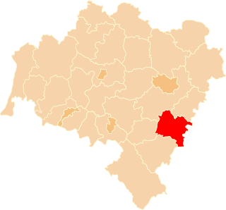
Tomice is a village in the administrative district of Gmina Głogówek, within Prudnik County, Opole Voivodeship, in south-western Poland, close to the Czech border. It lies approximately 4 kilometres (2 mi) south-west of Głogówek, 20 km (12 mi) east of Prudnik, and 40 km (25 mi) south of the regional capital Opole.
Puzdrowski Młyn is a settlement in the administrative district of Gmina Sierakowice, within Kartuzy County, Pomeranian Voivodeship, in northern Poland. It lies approximately 3 kilometres (2 mi) west of Sierakowice, 23 km (14 mi) west of Kartuzy, and 51 km (32 mi) west of the regional capital Gdańsk.
Popia Góra is a settlement in the administrative district of Gmina Karsin, within Kościerzyna County, Pomeranian Voivodeship, in northern Poland. It lies approximately 7 kilometres (4 mi) south-west of Karsin, 31 km (19 mi) south of Kościerzyna, and 76 km (47 mi) south-west of the regional capital Gdańsk.

Rich Valley is a hamlet in central Alberta, Canada within Lac Ste. Anne County. It is located on Highway 33, approximately 70 kilometres (43 mi) northwest of Edmonton.

Aïn El Melh is a town and commune in M'Sila Province, Algeria.
Levi is a village in Tori Parish, Pärnu County in southwestern Estonia.
Kõivuküla is a village in Kastre Parish, Tartu County in eastern Estonia.

Gåshamna is a bay at the southern side of Hornsund, Sørkapp Land, on Spitsbergen, Svalbard. The bay has a width of about 2 km, and is included within the Sør-Spitsbergen National Park.