
Bavaria, officially the Free State of Bavaria (German: Freistaat Bayern[ˈfʁaɪʃtaːt ˈbaɪɐn]; is a state in the south-east of Germany. With an area of 70,550.19 km2, Bavaria is the largest German state by land area, comprising roughly a fifth of the total land area of Germany. With over 13 million inhabitants, it is second in population only to North Rhine-Westphalia, but due to its large size its population density is below the German average. Bavaria's main cities are Munich, Nuremberg, and Augsburg.
The Federal Republic of Germany, as a federal state, consists of sixteen partly sovereign federated states. Since the German national state was formed from an earlier collection of several states, it has a federal constitution, and the constituent states retain a measure of sovereignty.

The Kingdom of Prussia was a German kingdom that constituted the state of Prussia between 1701 and 1918. It was the driving force behind the unification of Germany in 1871 and was the leading state of the German Empire until its dissolution in 1918. Although it took its name from the region called Prussia, it was based in the Margraviate of Brandenburg. Its capital was Berlin.

Prussia was a German state on the southeast coast of the Baltic Sea. It formed the German Empire under Prussian rule when it united the German states in 1871. It was de facto dissolved by an emergency decree transferring powers of the Prussian government to German Chancellor Franz von Papen in 1932 and de jure by an Allied decree in 1947. For centuries, the House of Hohenzollern ruled Prussia, expanding its size with the Prussian Army. Prussia, with its capital at Königsberg and then, when it became the Kingdom of Prussia in 1701, Berlin, decisively shaped the history of Germany.

The Flakpanzer IV Kugelblitz was a German self-propelled anti-aircraft gun developed during World War II. By the end of the war, only a pilot production of five units had been completed. Unlike earlier self-propelled anti-aircraft guns, it had a fully enclosed, rotating turret.

World War I, often abbreviated as WWI or WW1, and known to Anglophone authors as The Great War or War to End All Wars, was a global conflict spanning four years in which millions of people were killed. Belligerents included much of Europe, the Russian Empire, the United States, and the Ottoman Empire, with fighting occurring throughout Europe, the Middle East, Africa, the Pacific, and parts of Asia. New technology, including the recent invention of the airplane, trench warfare, and especially chemical weapons made it one of the deadliest conflicts in history. An estimated 9 million soldiers were killed in combat, plus another 23 million wounded, while 5 million civilians died as a result of military action, hunger, and disease. Millions more died in genocides within the Ottoman Empire and the 1918 influenza pandemic, which was exacerbated by the movement of combatants during the war.

Hainich is a forested hill chain in the state of Thuringia in Germany, between the towns of Eisenach, Mühlhausen and Bad Langensalza. Hainich covers an area of around 160 km², of which, since 31 December 1997, half has been designated as Hainich National Park. The highest point in Hainich is Alte Berg at 1621 ft. The Mühlhäuser Stadtwald in the northern part of Hainich is the largest municipal forest in Thuringia. The landmark of Hainich is Betteleiche, a 600-year-old common oak at Ihlefeld.
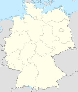
Creuzburg is a former Verwaltungsgemeinschaft in the district Wartburgkreis in Thuringia, Germany. The seat of the Verwaltungsgemeinschaft was in Creuzburg. It was disbanded on 31 December 2013, when its members joined the Verwaltungsgemeinschaft Mihla.
Hainich-Werratal is a Verwaltungsgemeinschaft in the district Wartburgkreis in Thuringia, Germany. The seat of the Verwaltungsgemeinschaft is in Amt Creuzburg.
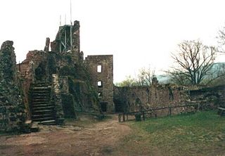
Hohnstein Castle is one of the largest and best-preserved castle ruins in Germany and is located near Neustadt in the vicinity of Nordhausen in Thuringia.

Austria, officially the Republic of Austria, is a landlocked country in the southern part of Central Europe, lying in the Eastern Alps. It is a federation of nine states, one of which is the capital, Vienna, the most populous city and state. The country is bordered by Germany to the northwest, the Czech Republic to the north, Slovakia to the northeast, Hungary to the east, Slovenia and Italy to the south, and Switzerland and Liechtenstein to the west. It occupies an area of 83,871 km2 (32,383 sq mi) and has a population of 9 million.
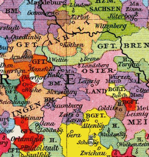
The Prince-Bishopric of Naumburg-Zeitz was a medieval diocese in the central German area between Leipzig in the east and Erfurt in the west. The seat of the bishop was Zeitz Cathedral in Zeitz from 968 and 1029 and Naumburg Cathedral in Naumburg between 1029 and 1615. It was dissolved in the wake of the Reformation. The Bishopric of Zeitz-Naumburg encompassed the four archdeaconries of Naumburg, Zeitz, Altenburg and "trans Muldam".

Lauterbach is a river of Thuringia, Germany. It flows into the Werra in Mihla.
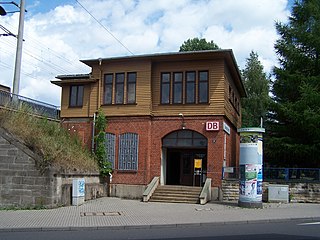
Eisenach West station is a halt (Haltepunkt) on the Halle–Bebra railway in the town of Eisenach in the German state of Thuringia.

Amt Creuzburg is a town in the Wartburgkreis district, in Thuringia, Germany. It was created with effect from 31 December 2019 by the merger of the former municipalities of Creuzburg, Ebenshausen and Mihla. It takes its name from the town Creuzburg, the centre of the new municipality.
Wartburgkreis III is an electoral constituency represented in the Landtag of Thuringia. It elects one member via first-past-the-post voting. Under the current constituency numbering system, it is designated as constituency 7. It covers the northern part of Wartburgkreis.
Hermann Hahn was a German architect. Hahn lived and worked in Eisenach, where he reached importance, particularly through his plans (designs) of numerous completed villas in Eisenach's south quarter. These mansion districts were established on the hillsides of Mariental valley in the construction boom between 1850 and 1914.
In Mandaeism, the pihta is a type of sacramental bread used with rituals performed by Mandaean priests. It is a small, round, biscuit-sized flatbread that can either be salted or saltless, depending on whether the ritual use of the pihta is for living or dead people.


