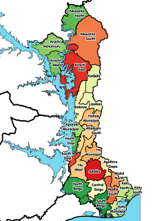
The Ho Municipal District is one of the twenty-five (25) districts in the Volta Region. The Ho Municipal district capital and administrative centre is Ho.
Wodników Górny is a village in the administrative district of Gmina Milicz, within Milicz County, Lower Silesian Voivodeship, in south-western Poland. Prior to 1945 it was in Germany.
Korea is part of Sobienie Szlacheckie village, Gmina Sobienie-Jeziory. From 1975 to 1998 this place was in Siedlce Voivodeship.

Smolany Sadek is a village in the administrative district of Gmina Hajnówka, within Hajnówka County, Podlaskie Voivodeship, in north-eastern Poland, close to the border with Belarus. It lies approximately 10 kilometres (6 mi) north of Hajnówka and 45 km (28 mi) south-east of the regional capital Białystok.

Leszno is a village in the administrative district of Gmina Kutno, within Kutno County, Łódź Voivodeship, in central Poland. It lies approximately 7 kilometres (4 mi) south-west of Kutno and 46 km (29 mi) north of the regional capital Łódź.

Nowe Osiny is a village in the administrative district of Gmina Mińsk Mazowiecki, within Mińsk County, Masovian Voivodeship, in east-central Poland.
Begno is a village in the administrative district of Gmina Staroźreby, within Płock County, Masovian Voivodeship, in east-central Poland.
Zawady B is a village in the administrative district of Gmina Nowe Miasto, within Płońsk County, Masovian Voivodeship, in east-central Poland.

Konstantynowo is a village in the administrative district of Gmina Ślesin, within Konin County, Greater Poland Voivodeship, in west-central Poland. It lies approximately 6 kilometres (4 mi) north of Ślesin, 22 km (14 mi) north of Konin, and 96 km (60 mi) east of the regional capital Poznań.

Kołczyn is a village in the administrative district of Gmina Krzeszyce, within Sulęcin County, Lubusz Voivodeship, in western Poland. It lies approximately 18 kilometres (11 mi) north of Sulęcin and 17 km (11 mi) south-west of Gorzów Wielkopolski.

Płonica is a village in the administrative district of Gmina Człuchów, within Człuchów County, Pomeranian Voivodeship, in northern Poland. It lies approximately 5 kilometres (3 mi) south of Człuchów and 118 km (73 mi) south-west of the regional capital Gdańsk.

Nowe Klęcinko is a village in the administrative district of Gmina Główczyce, within Słupsk County, Pomeranian Voivodeship, in northern Poland. It lies approximately 2 kilometres (1 mi) south-west of Główczyce, 27 km (17 mi) north-east of Słupsk, and 88 km (55 mi) west of the regional capital Gdańsk.

Dobrkowo is a village in the administrative district of Gmina Radowo Małe, within Łobez County, West Pomeranian Voivodeship, in north-western Poland. It lies approximately 10 kilometres (6 mi) south-west of Radowo Małe, 20 km (12 mi) west of Łobez, and 54 km (34 mi) north-east of the regional capital Szczecin.

Silverwood, Michigan is an unincorporated community on the border of Rich Township, Michigan, Lapeer County and Dayton Township, Tuscola County at 43°19′24″N83°14′53″W.
Cambuí is a municipality in the state of Minas Gerais in the Southeast region of Brazil.
Aidu-Sooküla is a village in Lüganuse Parish, Ida-Viru County in northeastern Estonia.

Speia is a village in the Grigoriopol sub-district of Transnistria, Moldova. It is currently under the administration of the breakaway government of the Transnistrian Moldovan Republic.
Kotsma is a village in Saaremaa Parish, Saare County in western Estonia.

Hellamaa is a village in Muhu Parish, Saare County in western Estonia.

Dūkštas Manor is a former residential manor in Dūkšteliai village, Ignalina District Municipality, Lithuania. Reconstruction works of the manor began in 2005; however, it was stuck until 2010 when it was continued.


