Mikhaylovsk

Last updated

Mikhaylovsk (Russian : Михайловск) is the name of several inhabited localities in Russia.

Russian language East Slavic language

Russian is an East Slavic language, which is official in the Russian Federation, Belarus, Kazakhstan and Kyrgyzstan, as well as being widely used throughout Eastern Europe, the Baltic states, the Caucasus and Central Asia. It was the de facto language of the Soviet Union until its dissolution on 25 December 1991. Although nearly three decades have passed since the breakup of the Soviet Union, Russian is used in official capacity or in public life in all the post-Soviet nation-states, as well as in Israel and Mongolia.

The classification system of the types of inhabited localities in Russia, the former Soviet Union, and some other post-Soviet states has certain peculiarities compared with the classification systems in other countries.

Contents

Urban localities

Mikhaylovsk, Stavropol Krai Town in Stavropol Krai, Russia

Mikhaylovsk is a town and the administrative center of Shpakovsky District in Stavropol Krai, Russia, located along the Tashla River, 10 kilometers (6.2 mi) northeast of Stavropol, the administrative center of the krai. Population: 70,981 (2010 Census); 58,153 (2002 Census); 42,993 (1989 Census).

Shpakovsky District District in Stavropol Krai, Russia

Shpakovsky District is an administrative district (raion), one of the twenty-six in Stavropol Krai, Russia. Municipally, it is incorporated as Shpakovsky Municipal District. It is located in the west of the krai. The area of the district is 2,363 square kilometers (912 sq mi). Its administrative center is the town of Mikhaylovsk. Population: 123,071 (2010 Census); 108,717 ; 84,561. The population of Mikhaylovsk accounts for 57.7% of the district's total population.

Stavropol Krai First-level administrative division of Russia

Stavropol Krai is a federal subject of Russia. It is geographically located in the North Caucasus region in Southern Russia, and is administratively part of the North Caucasian Federal District. Stavropol Krai has a population of 2,786,281 (2010).

Rural localities

Pochepsky District District in Bryansk Oblast, Russia

Pochepsky District is an administrative and municipal district (raion), one of the twenty-seven in Bryansk Oblast, Russia. It is located in the center of the oblast. The area of the district is 1,886 square kilometers (728 sq mi). Its administrative center is the town of Pochep. As of the 2010 Census, the total population of the district was 42,365, with the population of Pochep accounting for 40.5% of that number.

Bryansk Oblast First-level administrative division of Russia

Bryansk Oblast is a federal subject of Russia. Its administrative center is the city of Bryansk. As of the 2010 Census, its population was 1,278,217.

Starodubsky District District in Bryansk Oblast, Russia

Starodubsky District is an administrative and municipal district (raion), one of the twenty-seven in Bryansk Oblast, Russia. It is located in the south of the oblast. The area of the district is 1,760 square kilometers (680 sq mi). Its administrative center is the town of Starodub. Population: 40,414 (2010 Census); 44,573 ; 51,326 (1989 Census). The population of Starodub accounts for 47.0% of the district's total population.

See also

Michael male given name

Michael is a masculine given name that comes from Hebrew: מִיכָאֵל / מיכאל, derived from the question מי כאלmī kāʼēl, meaning "Who is like God?".

Related Research Articles

Selsoviet is a shortened name for a rural council and for the area governed by such a council (soviet). The full names for the term are, in Belarusian: се́льскi Саве́т, Russian: се́льский Сове́т, Ukrainian: сільська́ ра́да. Selsoviets were the lowest level of administrative division in rural areas in the Soviet Union. After the dissolution of the Soviet Union, they were preserved as a third tier of administrative-territorial division throughout Ukraine, Belarus, and some of the federal subjects of Russia.

Flags of the federal subjects of Russia Wikimedia list article

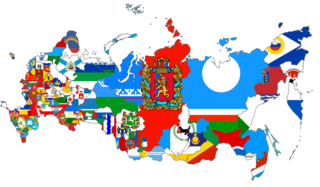
This gallery of flags of federal subjects of Russia shows the flags of the 85 federal subjects of Russia.

Progress is the name of several inhabited localities in Russia.

Sosnovy Bor is the name of several inhabited localities in Russia.

Rodniki is the name of several inhabited localities in Russia.

Russia has international borders with 16 sovereign states, including two with maritime boundaries, as well as with the partially recognized states of South Ossetia and Abkhazia. With a land border running 20,241 kilometres (12,577 mi) in total, Russia has, the second-longest land border of any country.

Olkhovka is the name of several rural localities in Russia.

Zarya is the name of several rural localities in Russia.

Druzhba is the name of several rural localities in Russia:

Svetly, Svetlaya, or Svetloye is the name of several inhabited localities in Russia.

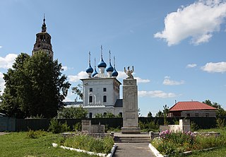
Krasnogvardeysky, Krasnogvardeyskaya, or Krasnogvardeyskoye is the name of several rural localities in Russia:

Gorny, Gornaya, or Gornoye is the name of several inhabited localities in Russia.

Ozyorny/Ozerny, Ozyornaya/Ozernaya, or Ozyornoye/Ozernoye is the name of several inhabited localities in Russia.

Khomutovka is the name of several inhabited localities in Russia.

Sergino is the name of several rural localities in Russia:

Pushkari is the name of several rural localities in Russia:

Mirny, Mirnaya, or Mirnoye is the name of several inhabited localities in Russia.

Kozlovsky, Kozlovskaya, or Kozlovskoye is the name of several rural localities in Russia:

Kolos is the name of several rural localities in Russia.