| Milijanovac | |
|---|---|
| Village | |
| Country | |
| County | Bjelovar-Bilogora County |
| Municipality | Sirač |
| Population (2011) [1] | |
| • Total | 160 |
| Time zone | CET (UTC+1) |
| • Summer (DST) | CEST (UTC+2) |
| Milijanovac | |
|---|---|
| Village | |
| Country | |
| County | Bjelovar-Bilogora County |
| Municipality | Sirač |
| Population (2011) [1] | |
| • Total | 160 |
| Time zone | CET (UTC+1) |
| • Summer (DST) | CEST (UTC+2) |
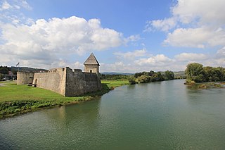
Hrvatska Kostajnica, often just Kostajnica, is a small town in central Croatia. It is located on the Una river in the Sisak-Moslavina County, south of Petrinja and Sisak and across the river from Bosanska Kostajnica in Bosnia and Herzegovina.

Babina Greda is a village and a municipality in Vukovar-Srijem County in eastern Croatia. The 2011 census listed 3,572 inhabitants in Babina Greda.

Runović is a village in the municipality of Runovići in Croatia, in the Split-Dalmatia County. It has a population of 2,409, 99.71% which are Croats. There are three settlements in the municipality:
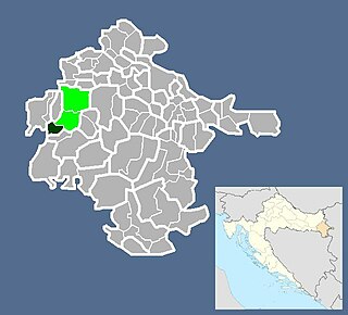
Sirač is a settlement and municipality in Bjelovar-Bilogora County, Croatia. There are 2,218 inhabitants; 73% are Croats, 14% Serbs, and 11% Czechs. The following settlements make up the municipality: Barica, Bijela, Donji Borki, Gornji Borki, Kip, Miljanovac, Pakrani, Sirač, Šibovac.
Podcrkavlje is a municipality in Brod-Posavina County, Croatia. There are 2,683 inhabitants in which 98% declare themselves Croats.
Susek is a village in Serbia. It is situated in the Beočin municipality, in the Vojvodina province. Although, the village is geographically located in Syrmia, it is part of the South Bačka District. The village has a Serb ethnic majority and its population numbering 1,132 people.
Podravske Sesvete is a municipality in the Koprivnica–Križevci County in Croatia. According to the 2011 census, there are 1,630 inhabitants in the area.
Petrijevci is a municipality in Slavonia, in the Osijek-Baranja County of northeastern Croatia. There are 2439 inhabitants, of which 97.39% are Croats.
Nemetin is a village in eastern Slavonia, Croatia, located near Osijek. It has a population of 139. It is administratively located within the area of the city of Osijek.

Andrijaševci is a village and the eponymous municipality in Vukovar-Srijem County in eastern Croatia. The 2011 census listed a total of 4,075 inhabitants in the municipality's two settlements:
Novi Varoš is a village in Croatia. It is connected by the D5 highway.
Cage is a village in Croatia. It is connected by the D5 highway.
Dužica is a village in Croatia. It is connected by the D30 highway.
Zamost is a village in Croatia.
Šljivoševci is a village in Croatia.
Prkovci is a village in Croatia.
Mušalež is a village in Croatia.
Lovrečica or San Lorenzo is a village in Croatia. It is part of Umag.
Šimraki is a settlement (naselje) in the Samobor administrative territory of Zagreb County, Croatia. As of 2011 it had a population of 5 people.
Bukevje is a settlement (naselje) in the Sveti Ivan Zelina administrative territory of Zagreb County, Croatia. As of 2011 it had a population of 84 people.
Coordinates: 45°32′N17°13′E / 45.533°N 17.217°E

A geographic coordinate system is a coordinate system that enables every location on Earth to be specified by a set of numbers, letters or symbols. The coordinates are often chosen such that one of the numbers represents a vertical position and two or three of the numbers represent a horizontal position; alternatively, a geographic position may be expressed in a combined three-dimensional Cartesian vector. A common choice of coordinates is latitude, longitude and elevation. To specify a location on a plane requires a map projection.
| This Bjelovar-Bilogora County geography article is a stub. You can help Wikipedia by expanding it. |