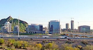
Tempe is a city in Maricopa County, Arizona, United States, with the Census Bureau reporting a 2020 population of 180,587. The city is named after the Vale of Tempe in Greece. Tempe is located in the East Valley section of metropolitan Phoenix; it is bordered by Phoenix and Guadalupe on the west, Scottsdale and the Salt River Pima–Maricopa Indian Community on the north, Chandler on the south, and Mesa on the east. Tempe is also the location of the main campus of Arizona State University.
The Bronx River Parkway is a 19.12-mile (30.77 km) long parkway in downstate New York in the United States. It is named for the nearby Bronx River, which it parallels. The southern terminus of the parkway is at Story Avenue near the Bruckner Expressway in the Bronx neighborhood of Soundview. The northern terminus is at the Kensico Circle in Valhalla, Mount Pleasant, Westchester County, where the parkway connects to the Taconic State Parkway and, via a short connector, New York State Route 22 (NY 22). Within the Bronx, the parkway is maintained by the New York State Department of Transportation and is designated New York State Route 907H (NY 907H), an unsigned reference route. In Westchester County, the parkway is maintained by the Westchester County Department of Public Works and is designated unsigned County Route 9987 (CR 9987).

The River Usk rises on the northern slopes of the Black Mountain, Wales, in the westernmost part of the Brecon Beacons National Park. Initially forming the boundary between Carmarthenshire and Powys, it flows north into Usk Reservoir, then east by Sennybridge to Brecon before turning southeast to flow by Talybont-on-Usk, Crickhowell and Abergavenny after which it takes a more southerly course.
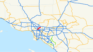
The Arroyo Seco Parkway, also known as the Pasadena Freeway, is the first freeway built in the United States. It connects Los Angeles with Pasadena alongside the Arroyo Seco seasonal river. It is notable not only for being the first, mostly opened in 1940, but for representing the transitional phase between early parkways and modern freeways. It conformed to modern standards when it was built, but is now regarded as a narrow, outdated roadway. A 1953 extension brought the south end to the Four Level Interchange in downtown Los Angeles and a connection with the rest of the freeway system.

The Gila River is a 649-mile (1,044 km)-long tributary of the Colorado River flowing through New Mexico and Arizona in the United States. The river drains an arid watershed of nearly 60,000 square miles (160,000 km2) that lies mainly within the U.S., but also extends into northern Sonora, Mexico.

The Salt River is a river in Gila and Maricopa counties in Arizona, United States, that is the largest tributary of the Gila River. The river is about 200 miles (320 km) long. Its drainage basin is about 13,700 square miles (35,000 km2) large. The longest of the Salt River's many tributaries is the 195-mile (314 km) Verde River. The Salt's headwaters tributaries, the Black River and East Fork, increase the river's total length to about 300 miles (480 km). The name Salt River comes from the fact that the river flows over large salt deposits shortly after the merging of the White and Black Rivers.

The Barwon River is a perennial river of the Corangamite catchment, located in The Otways and the Bellarine Peninsula regions of the Australian state of Victoria.

A reversible lane is a lane in which traffic may travel in either direction, depending on certain conditions. Typically, it is meant to improve traffic flow during rush hours, by having overhead traffic lights and lighted street signs notify drivers which lanes are open or closed to driving or turning.

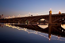
Tempe Town Lake is an artificial perennial reservoir located just north of Tempe Butte at the confluence of the intermittent Salt River and the ephemeral Indian Bend Wash in Tempe, Arizona, United States. The reservoir receives much of its water from the Colorado River via the Central Arizona Project.

The Apache Trail in Arizona was a stagecoach trail that ran through the Superstition Mountains. It was named the Apache Trail after the Apache Indians who originally used this trail to move through the Superstition Mountains.
The Saw Mill River Parkway is a north–south parkway that extends for 28.93 miles (46.56 km) through Westchester County, New York, in the United States. It begins at the border between Westchester County and the Bronx, as the continuation of the Henry Hudson Parkway leaving New York City, and heads generally northeastward to an interchange with Interstate 684 (I-684). At its north end, the parkway serves as a collector/distributor road as it passes east of the hamlet of Katonah. The parkway is named for the Saw Mill River, which the highway parallels for most of its length.

FrontRunner is a commuter rail train operated by the Utah Transit Authority that operates along the Wasatch Front in north-central Utah with service from Ogden in central Weber County through Davis County, Salt Lake City, and Salt Lake County to Provo in central Utah County.

Tempe Butte is the official name of an andesite butte of volcanic origin, located partially on Arizona State University's Tempe campus in Tempe, Arizona. It is often referred to by locals as A Mountain, after the 60-foot-tall (18 m) gold-painted letter 'A' near the top. Another name for the area, used by the City of Tempe, is Hayden Butte.
Interstate 95 (I-95) is an Interstate highway running from Miami, Florida, north to Houlton, Maine. In the U.S. state of Pennsylvania, it runs 44.25 miles (71.21 km) from the Delaware state line near Marcus Hook in Delaware County northeast to the Delaware River–Turnpike Toll Bridge at the New Jersey state line near Bristol in Bucks County. From the Delaware state line to exit 40, the route is known by many as the Delaware Expressway, but is officially named the Vietnam Veterans Memorial Highway. North of exit 40, I-95 runs along the easternmost portion of the Pennsylvania Turnpike; this portion of road is not signed as part of the turnpike. I-95 parallels its namesake Delaware River for its entire route through the city of Philadelphia and its suburbs. It is a major route through the city and the metropolitan Delaware Valley, providing access to locally important landmarks such as Subaru Park, Philadelphia International Airport, the South Philadelphia Sports Complex, Penn's Landing, and Philadelphia Mills.
The Johnsonville–Porirua Motorway is a motorway in Wellington, New Zealand. The majority of the motorway forms part of State Highway 1, the main route of traffic in and out of the city, with the northernmost 2.1 km (1.3 mi), formerly part of SH 1 until 7 December 2021, designated as State Highway 59. Completed in the 1950s, it was New Zealand's first motorway.

The U.S. 40 and 59 Bridges are twin multi-beam girder bridges over the Kansas River at Lawrence, Kansas. The west bridge carries two lanes of southbound traffic, connecting to Vermont Street, while the east bridge carries two lanes of northbound traffic from Massachusetts Street. Both bridges converge on the north end to become North 2nd Street. The east bridge is also the third bridge to be built at this location.
Many arterial roads in the Phoenix metropolitan area have the same name in multiple cities or towns. Some roads change names or route numbers across town borders, resulting in occasional confusion. For example, the road known as Apache Boulevard in Tempe continues east as Main Street in neighboring Mesa and then as Apache Trail in Apache Junction. Although Broadway Road maintains the same name through Goodyear, Avondale, Phoenix, Tempe, Mesa, and Apache Junction, each town uses a different reference point for address numbers.
The following is a timeline of the history of the city of Phoenix, Arizona, United States.

Calgary Trail and Gateway Boulevard are a pair of major arterial roadways in Edmonton, Alberta. Gateway Boulevard carries northbound traffic while Calgary Trail carries southbound traffic. From south of 31 Avenue, they form a two-way freeway separated by a median; for this portion, the roadway maintains the separate names for northbound and southbound traffic. Near 31 Avenue, Calgary Trail and Gateway Boulevard separate and become parallel one-way arterial roadways to Saskatchewan Drive, at the edge of the North Saskatchewan River valley. Designated as part of Highway 2 south of Whitemud Drive, it is Edmonton's main southern entrance and is both a major commuter route, connecting to the Edmonton International Airport and Leduc, as well as a regional connection to Red Deer, and Calgary.