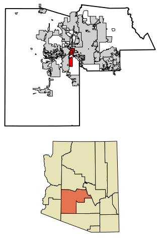
Avondale is a city in Maricopa County, Arizona, United States, adjacent to Phoenix. As of the 2020 census, the population of the city was 89,334, up from 76,238 in 2010 and 35,883 in 2000.

New River is an unincorporated community and census-designated place (CDP) in Maricopa County, Arizona, United States. The population was 17,290 as of the 2020 census, up from 14,952 at the 2010 census.
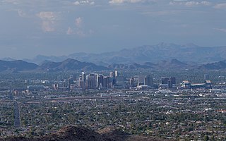
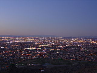
The Phoenix Metropolitan Area – also the Valley of the Sun, the Salt River Valley, or Metro Phoenix – is the largest metropolitan statistical area in the Southwestern United States, centered on the city of Phoenix, that includes much of the central part of Arizona. The United States Office of Management and Budget designates the area as the Phoenix-Mesa-Chandler Metropolitan Statistical Area (MSA), defining it as Maricopa and Pinal counties. It anchors the Arizona Sun Corridor megaregion along with the second most populous metropolitan area in the state, the Tucson metropolitan area. The gross domestic product of the Phoenix Metropolitan Area was $255 billion in 2018, 16th largest amongst metro areas in the United States.

South Mountain Park in Phoenix, Arizona is the largest municipal park in the United States, and one of the largest urban parks in North America and in the world. It has been designated as a Phoenix Point of Pride.

The Arizona Canal is a major canal in central Maricopa County that led to the founding of several communities, now among the wealthier neighborhoods of suburban Phoenix, constructed in the late 1880s. Flood irrigation of residential yards is still common in these neighborhoods, using a system of lateral waterways connected via gates to the canal itself. Like most Valley canals, its banks are popular with joggers and bicyclists.

The South Mountains, known locally as simply South Mountain, is a mountain range in central Arizona in south Phoenix, Arizona. It is on public land managed by the city of Phoenix as South Mountain Park.

The Apache Trail in Arizona was a stagecoach trail that ran through the Superstition Mountains. It was named the Apache Trail after the Apache Indians who originally used this trail to move through the Superstition Mountains.
Ford Motor Company operates several proving grounds worldwide, for development and validation testing of new vehicles.

The Salt River Pima–Maricopa Indian Community comprises two distinct Native American tribes—the Pima and the Maricopa —many of whom were originally part of the Halchidhoma (Xalchidom) tribe. The community was permanently created by an Executive Order of US President Rutherford Birchard Hayes on Saturday, June 14th, 1879. The community area includes 53,600 acres (217 km2), of which 19,000 remain a natural preserve. As of 2022, the total population is 7,386. The community is a federally recognized tribe located in Arizona.

North/Northwest Phoenix is a region in the city of Phoenix, Arizona. While the area with this name has no official separate status, it usually refers to the Urban Villages of Paradise Valley, North Mountain, Deer Valley, Desert View, and North Gateway.
South Phoenix is a region of Phoenix, Arizona. By one definition it encompasses an area south of the Salt River, north of Roeser Road, east of 24th Street, and west of 32nd Street.

Komatke is a census-designated place in Maricopa County, Arizona, United States. The area currently comprising the census-designated place had a population of 1,013 at the 2020 census, up from 821 at the 2010 census. It is located within the Gila River Indian Community. Its name refers to the Sierra Estrella mountain range, which rises just to the southwest of Komatke.

The Arizona State Fair is an annual state fair, held at Arizona State Fairgrounds.
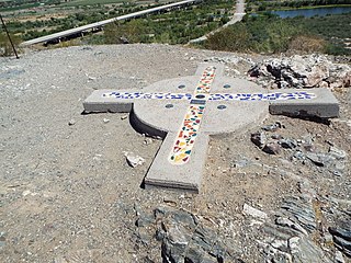
The Gila and Salt River Meridian intersects the initial point on the south side of the Gila River, opposite the mouth of Salt River, at latitude 33° 22′ 37.82733″ north, longitude 112° 18′ 21.99931″ west from Greenwich based on NAD 83, and governs the surveys in the territory of Arizona. The current declination for the initial point is 12° east. It is located on Monument Hill, an easily visible hill just south of the confluence of the Gila and Salt Rivers, in Avondale, Arizona, about 14 miles southwest of downtown Phoenix.
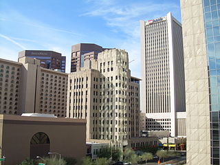
Central City Village is the urban village of Phoenix, Arizona, that includes the downtown area of the city. As of 2010, it had a population of 58,161 residents.

The Gila Bend Mountains are a 35-mile (56 km) long mountain range of the north-central Sonoran Desert southwest of Phoenix, Arizona and in southwest Maricopa County.
The Belmont Mountains are a 25 mi (40 km) long, arid, low elevation mountain range about 50 mi west of Phoenix, Arizona in the northern Sonoran Desert, north of the Gila River. The range is in the south of a region of two parallel washes; the Bouse Wash flows northwest to the Colorado River, and the Centennial Wash flows southeast to meet the Gila River.
The West Valley is a region within the Phoenix metropolitan area, in central Arizona.

Deer Valley or Deer Valley Village is one of the 15 urban villages that make up Phoenix, Arizona, United States. As of 2010, the population was 165,656, 25% of whom were under 18 years of age. The origin of the name is unclear; it first appeared on a 1921 General Land Office map of the area describing the valley created by Skunk Creek.
The following is a timeline of the history of the city of Phoenix, Arizona, United States.
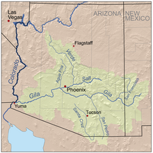
 Graphic of the "Salt River Drainage", the Mogollon Rim, and the Arizona transition zone (central-west region)