The Kickapoo River is a 126-mile-long (203 km) tributary of the Wisconsin River in the state of Wisconsin, United States. It is named for the Kickapoo Indians who occupied Wisconsin before the influx of white settlers in the early 19th century.

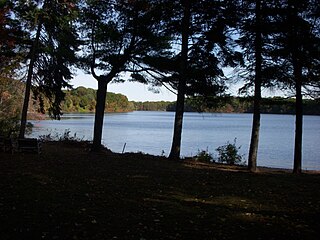
Lake Sabbatia, sometimes known as Scaddings Pond is a 248-acre great pond in Taunton, Massachusetts, near Watson Pond State Park. The lake is where Mill River begins and the Snake River ends. It is the largest lake in the city of Taunton and the most popularly used. There are several coves and an island within the lake. Parts of its coastline are populated with woods, streets, and residential homes. Lake Sabbatia is used for a variety of recreational activities such as boating, swimming, fishing, and ice fishing. There is a boat ramp off Bay Street into the lake.
The Satucket River is 5.5-mile-long (8.9 km) river in southeastern Massachusetts within the Taunton River Watershed. It flows generally west from Robbins Pond in East Bridgewater, and into the Matfield River.
The Quequechan River is a river in Fall River, Massachusetts, that flows in a northwesterly direction from the northwest corner of the South Watuppa Pond through the heart of the city of Fall River and into the end of the Taunton River at Mount Hope Bay at Heritage State Park/Battleship Cove. The word Quequechan means "Falling River" or "Leaping/Falling Waters" in Wampanoag, hence the city's name.

The Water Shops Armory, located at 1 Allen Street, was a part of the Springfield Armory in Springfield, Massachusetts. Developed beginning in 1857, it served as the heavy manufacturing complex for the armory. It was listed on the National Register of Historic Places in 1980.

The Canoe River is a river in southeastern Massachusetts. It is 14.4 miles (23.2 km) long and part of the Taunton River Watershed.
The Quinebaug River is a river in south-central Massachusetts and eastern Connecticut, with watershed extending into western Rhode Island. The name "Quinebaug" comes from the southern New England Native American term, spelled variously Qunnubbâgge, Quinibauge, etc., meaning "long pond", from qunni-, "long", and -paug, "pond". The river is one of the namesake rivers in the Quinebaug and Shetucket Rivers Valley National Heritage Corridor.

Town Brook is a 1.5-mile (2.4 km) stream in Plymouth, Massachusetts that provided drinking water to the Pilgrims who made their homes adjacent to the brook on Leyden Street in Plymouth. Town Brook's headwaters are the Billington Sea, a 269-acre (109 ha) freshwater pond. The brook passes through numerous small ponds, including Deep Water Pond and Jenny Pond. It also passes by the Plimoth Grist Mill and the Brewster Gardens before emptying into Plymouth Harbor. A nature trail runs along the entire length of the brook.

Mill Pond is a 13-acre (53,000 m2) pond in Duxbury, Massachusetts in the village of Island Creek. The pond is located south of Island Creek Pond. Island Creek runs through the pond. Route 3A runs along the southern shore of the pond. The water quality is impaired due to non-native aquatic plants in the pond. The fishway at the Mill Pond dam has deteriorated and no longer functions.
Lake Cochituate is a body of water in Natick, Wayland, and Framingham, Massachusetts, United States. Originally a reservoir serving Boston, it no longer serves that function, and is now a local recreational resource and home to Cochituate State Park.

The Indian Head River rises on the southern boundary of Hanover, Massachusetts and northern boundary line of Hanson, Massachusetts at the intersection of tributaries from Drinkwater River in Hanover and Indian Head Brook in Hanson. The river then flows east along the Hanover-Pembroke border. The river, 3.7 miles (6.0 km) long, is a tributary of the North River, which flows into Massachusetts Bay. The Indian Head River was an important fishing and water pathway for the Massachuset Indian village of Mattakeeset which was located around the Pembroke Ponds.

The Hayward Mill is a historic mill complex at the junction of North and Cook Streets, on the Mumford River in Douglas, Massachusetts. The site, with an industrial history dating to the 18th century, is populated by a series of connected buildings dating to 1880 or later. The mill was the first financial successful textile operation in Douglas, and was operated until the 1960s. The mill complex was listed on the National Register of Historic Places in 1991. It has been converted to residential use.
The West River, in the US state of Massachusetts, is a 13.4-mile-long (21.6 km) tributary of the Blackstone River.

The Bisbee Mill is a historic gristmill at 66 East Street in Chesterfield, Massachusetts. Located on the Dead Branch of the Westfield River, the mill complex includes a wood frame mill building, along with its former mill pond, impounded by a dam across the river, and a canal that brought river water to the mill for power. Also included on the property is the site of the Damon sawmill, which was established in 1761, and the Pierce cornmill, which occupied a site north of the Bisbee mill building in 1823. The Pierce mill was moved to the site, from an earlier one that may also be on the grounds of the Bisbee mill complex.

Ascutney Mill Dam, also known as the Windsor Upper Dam and the Mill Pond Dam, is an arch-gravity dam which is one of the oldest and among the earliest storage dams in the United States. It is made of cut granite and is located in Windsor, Vermont in Windsor County near the Connecticut River, where it functioned as a source of hydropower and, later, hydroelectric power. It is on the ASCE list of historic civil engineering landmarks since 1970 and is listed on the National Register of Historic Places since January 09, 2007.

Stony Brook is a stream largely running through Lincoln and Weston, Massachusetts, then forming the Weston/Waltham boundary, and emptying into the Charles River across from the Waltham/Newton boundary. It has two tributaries, Cherry Brook and Hobbs Brook, and its watershed includes about half of Lincoln and Weston as well as parts of Lexington and Waltham. Since 1887, it has been the water supply for Cambridge, along with the Hobbs Brook Reservoir.
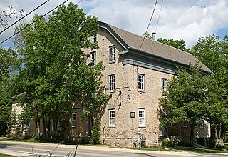
The Concordia Mill is a former gristmill on Cedar Creek located in Hamilton, Wisconsin, United States. The limestone mill was built in 1853 by Edward H. Janssen and his brother, Theodore, along with a Mr. Gaitsch with locally quarried limestone. In 1881, the mill's dam washed out during heavy spring flooding and was rebuilt sometime later. The mill operated until World War II when it was converted into a distillery that operated for several years. On April 26, 1974, it was added to the National Register of Historic Places, and the surrounding area, known as the Hamilton Historic District was added to the NRHP two years later.
Stony Brook is a tributary of the Merrimack River in northeastern Massachusetts, joining the Merrimack at Chelmsford.

The Botany Water Reserves are a heritage-listed former water supply system and now parkland and golf course at 1024 Botany Road, Mascot, Bayside Council, Sydney, New South Wales, Australia. It was designed by City Engineers, W. B. Rider, E. Bell (1856–1871), and Francis Bell (1871–1878). It is also known as Botany Swamps, Botany Wetlands, Mills Stream, Bridge Pond, Lakes Golf Course, Eastlakes Golf Course, Bonnie Doon Golf Course, and Astrolabe Park. The property is owned by Sydney Water, an agency of the Government of New South Wales. It was added to the New South Wales State Heritage Register on 18 November 1999.

Log Pond Cove, previously known as Money Hole, is a former log pond and scenic wayside on the Connecticut River, about half a mile upstream from the Holyoke Dam at South Hadley Falls.