Haverford Township is a home rule municipality township in Delaware County, Pennsylvania, United States. Haverford is named after the town of Haverfordwest in Wales. It is a commuting suburb located due west of Philadelphia and is officially known as the Township of Haverford. Despite being under a home rule charter since 1977, it continues to operate under a Board of Commissioners divided into wards, as do "First Class" townships that are still under the Pennsylvania Township Code. Haverford Township was founded in 1682 and incorporated in 1911.

MillbourneBorough is a self-governing municipal borough in Delaware County, Pennsylvania, United States. As of the 2020 census, the population is 1,212. Millbourne borders Philadelphia along Cobbs Creek. The name "Millbourne" comes from the word Mill and "bourne" meaning creek.

Ridley Park is a borough in Delaware County, Pennsylvania, United States. The population was 7,002 at the 2010 census. Ridley Park is the home of Boeing's CH-47 Chinook helicopter division.

Upper Darby Township, often shortened to Upper Darby, is a home rule township in Delaware County, Pennsylvania, United States. As of the 2020 census, the township had a total population of 85,681, making it the state's sixth-most populated municipality after Philadelphia, Pittsburgh, Allentown, Reading, and Erie. Upper Darby borders Philadelphia, the nation's sixth-most populous city, and constitutes part of the Delaware Valley, also known as the Philadelphia metropolitan area, the nation's seventh-largest metropolitan area.

Brandywine Creek is a tributary of the Christina River in southeastern Pennsylvania and northern Delaware in the United States. The Lower Brandywine is 20.4 miles (32.8 km) long and is a designated Pennsylvania Scenic River with several tributary streams. The East Branch and West Branch of the creek originate within 2 miles (3 km) of each other on the slopes of Welsh Mountain in Honey Brook Township, Pennsylvania, about 20 miles (32 km) northwest of their confluence.
Thomas Smith was a Federalist member of the United States House of Representatives who served Pennsylvania's 1st congressional district from 1815 to 1817.

Upper Darby School District (UDSD) is a large public school district of approximately 12,000 students in Upper Darby Township, Delaware County, Pennsylvania. It consists of an 8.3-square-mile (21 km2) area including Upper Darby Township, Clifton Heights borough, and Millbourne borough. According to 2009 local census data, it serves a resident population of 90,000. In 2009, the district residents’ per capita income was $20,699, while the median family income was $51,965. In the Commonwealth, the median family income was $49,501 and the United States median family income was $49,445, in 2010.

Pennsylvania Route 3 is a 24.3-mile (39.1 km) state highway located in the southeastern portion of Pennsylvania. The route runs from U.S. Route 322 Business in West Chester east to PA 611 in Philadelphia.
Millbourne station is a rapid transit station on SEPTA's Market-Frankford Line, located adjacent east of an intersection between Millbourne Avenue and Wister Drive in Millbourne, Pennsylvania. It is one of two ground-level stops on the Market–Frankford Line, as well as one of two SEPTA rapid transit stations located outside the Philadelphia city limits. The station lies two blocks north of the line's namesake street.
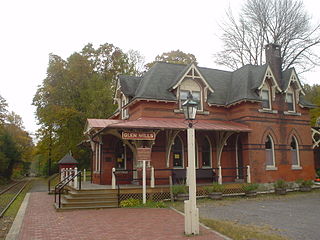
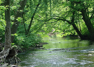
Glen Mills is an unincorporated community in Concord Township, Delaware County, Pennsylvania, United States, located approximately 27 miles west of Philadelphia. The ZIP Code for Glen Mills is 19342.

U.S. Route 1 (US 1) is a major north–south U.S. Route, extending from Key West, Florida, in the south to Fort Kent, Maine, at the Canada–United States border in the north. In the U.S. state of Pennsylvania, US 1 runs for 81 miles (130 km) from the Maryland state line near Nottingham northeast to the New Jersey state line at the Delaware River in Morrisville, through the southeastern portion of the state. The route runs southwest to northeast and serves as a major arterial road through the city of Philadelphia and for many of the suburbs in the Delaware Valley metropolitan area. South of Philadelphia, the road mostly follows the alignment of the Baltimore Pike. Within Philadelphia, it mostly follows Roosevelt Boulevard. North of Philadelphia, US 1 parallels the route of the Lincoln Highway. Several portions of US 1 in Pennsylvania are freeways, including from near the Maryland state line to Kennett Square, the bypass of Media, the concurrency with Interstate 76 and the Roosevelt Expressway in Philadelphia, and between Bensalem Township and the New Jersey state line.

U.S. Route 13 (US 13) is a United States Numbered Highway running from Fayetteville, North Carolina, north to Morrisville, Pennsylvania. The route runs for 49.359 miles (79.436 km) through the Delaware Valley in the U.S. state of Pennsylvania. The route enters the state from Delaware in Marcus Hook, Delaware County. It continues northeast through Delaware County, passing through the city of Chester before heading through suburban areas along Chester Pike to Darby. US 13 enters the city of Philadelphia on Baltimore Avenue and runs through West Philadelphia to University City, where it turns north along several city streets before heading east across the Schuylkill River along Girard Avenue. The route turns north and heads to North Philadelphia, where it runs northeast along Hunting Park Avenue. US 13 becomes concurrent with US 1 on Roosevelt Boulevard, continuing into Northeast Philadelphia. US 13 splits southeast on a one-way pair of streets before heading northeast out of the city on Frankford Avenue. The route continues into Bucks County as Bristol Pike, heading northeast to Bristol, where it becomes a divided highway. US 13 becomes a freeway in Tullytown and continues north to its terminus at US 1 in Falls Township, near Morrisville. US 13 roughly parallels Interstate 95 (I-95) through its course in Pennsylvania.
The Mill at Anselma is an archetypal small, 18th-century custom grain mill in Anselma, outside Chester Springs, Pennsylvania. It is probably the only surviving one in the United States with an intact colonial-era power transmission system. A custom grain mill typically ground cornmeal and flour only for local farmers, not for commercial distribution. It was designated a National Historic Landmark in 2005.
The Newtown Square Branch was a branch line of the Pennsylvania Railroad (PRR) that diverged from the West Chester Branch in Yeadon, Pennsylvania, and ended in Newtown Square, Pennsylvania.

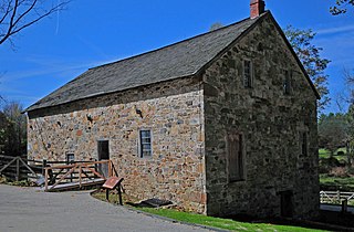
The Newlin Mill Complex, also referred to as The Newlin Grist Mill, is a water-powered gristmill on the west branch of Chester Creek near Concordville, Pennsylvania built in 1704 by Nathaniel and Mary Newlin and operated commercially until 1941. During its three centuries of operation, the mill has been known as the Lower Mill, the Markham Mill, the Seventeen-O-Four Mill and the Concord Flour Mill. In 1958 the mill property was bought by E. Mortimer Newlin, restored and given to the Nicholas Newlin Foundation to use as a historical park. Water power is still used to grind corn meal which is sold on site. The park includes five historical buildings, which were added to the National Register of Historic Places in 1983, and 150 acres (61 ha) of natural woodland.
A gristmill grinds cereal grain into flour and middlings. The term can refer to either the grinding mechanism or the building that holds it. Grist is grain that has been separated from its chaff in preparation for grinding.

Craigsville is an unincorporated community in West Franklin Township Armstrong County, Pennsylvania, United States. The community is 7.1 miles (11.4 km) west-northwest of the county seat, Kittanning.
The Sellers family of Philadelphia and Delaware County, Pennsylvania, are a family of scientists and engineers. More members of the Sellers family and the closely related Peale family have belonged to the American Philosophical Society than any other family in the history of the United States, and the same is true of the Academy of Natural Sciences, the Franklin Institute, and the Pennsylvania Academy of the Fine Arts.

Sellers Hall, located in Upper Darby and completed in 1684, is one of the oldest buildings in Pennsylvania and is the ancestral home of the Sellers family of scientists and engineers.

David Trainer was an American textile manufacturer and banker from Chester, Pennsylvania.

