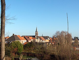
Putte is a village on the border between Belgium and the Netherlands.
Leeuwergem is a village belonging to the municipality of Zottegem. It is located on the Molenbeek, in the Denderstreek and Flemish Ardennes, which is part of the hilly southern part of the East Flanders province, Belgium.

Opbrakel is a village and deelgemeente (sub-municipality) of the municipality of Brakel. It is located in the Denderstreek in the province of East Flanders in Belgium. It used to be an independent municipality until 1971 when it was merged into Brakel.

Parike is a village and deelgemeente (sub-municipality) of the municipality of Brakel. It is located in the Denderstreek in the province of East Flanders in Belgium. It used to be an independent municipality until 1977 when it was merged into Brakel.

Erwetegem is a village and deelgemeente (sub-municipality) belonging to the municipality of Zottegem. It is located in the Denderstreek and in the Flemish Ardennes, the hilly southern part of the province of East Flanders, Belgium. Erwetegem used to an independent municipality until 1970.

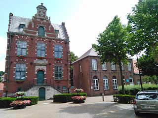
Beerzel is a Belgian village in Antwerp Province and a deelgemeente of the municipality Putte. Beerzel was a municipality until 1977, at which time it had an area of 7.83 square kilometres (3.02 sq mi) with 4,971 inhabitants in 1995. At 51.6 metres (169 ft), Antwerp's highest point—the Beerzelberg—is located in Beerzel.
Vinderhoute is a village in the municipality of Lievegem in the province of East Flanders in Belgium. It is located in the Flemish Valley about 6 kilometres (3.7 mi) north-west of Ghent.

Zevergem is a village and deelgemeente (sub-municipality) of De Pinte in East Flanders, Belgium. It is located on the Scheldt about 8 kilometres (5.0 mi) south of Ghent.

Hansbeke is a village and deelgemeente (sub-municipality) in the municipality of Deinze in the Belgian province of East Flanders. The village is located about 13 kilometres (8.1 mi) west of Ghent.

Kieldrecht is a village and deelgemeente (sub-municipality) of Beveren in East Flanders, Belgium. Kieldrecht was an independent municipality until 1977, when it merged with Beveren as part of the fusion of municipalities in Belgium. The village is located on the border with the Netherlands, and forms a single urban area with the Dutch village of Nieuw-Namen.
Vrasene is a village in the municipality of Beveren in the Belgian province of East Flanders. It is located about 15 kilometres (9.3 mi) east of Antwerp.

Haasdonk is a village and deelgemeente (sub-municipality) of Beveren in East Flanders, Belgium. Haasdonk was an independent municipality until 1 January 1977, when it merged with Beveren as part of the fusion of municipalities in Belgium. It is located about 12 kilometres (7.5 mi) west of Antwerp.

Sleidinge is a village in the municipalities of Evergem in the province of East Flanders, Belgium. It is located about 10 kilometres (6.2 mi) north-west of Ghent.

Kluizen is a village in the municipalities of Evergem and Ghent in the province of East Flanders, Belgium. Large parts of the original municipality have become part of the Port of Ghent.

Rutten is a village in the Tongeren municipality of the Limburg province in the Flemish Community of Belgium. The village is located in the Haspengouw region, and was a separate municipality until its merger into Tongeren in 1977.

Meer is a village in the Belgian municipality of Hoogstraten in the province of Antwerp. As of 2021, it has 3,542 inhabitants.
Meerle is a village in the Belgian municipality of Hoogstraten in the province of Antwerp. As of 2021, it has about 3,871 inhabitants.

Kallo is a village and deelgemeente (sub-municipality) of Beveren in East Flanders, Belgium. Kallo was an independent municipality until 1 January 1977, when it merged with Beveren as part of the fusion of municipalities in Belgium. Most of the deelgemeente consists of harbours and industrial zones.
Bevere is a village in the municipality of Oudenaarde. It is located in the Flemish Ardennes, the hilly southern part of the province of East Flanders, Belgium. In the mid-19th century, it started to form a single urban area with Oudenaarde, but retained some rural parts.
Ouwegem is a village and deelgemeente (sub-municipality) in the municipality of Kruisem in the province of East Flanders in Belgium. The village is located on the edge of the Flemish Ardennes and about 17 kilometres (11 mi) south-west of Ghent.