
The Great River Road is a collection of state and local roads that follow the course of the Mississippi River through ten states of the United States. They are Minnesota, Wisconsin, Iowa, Illinois, Missouri, Kentucky, Tennessee, Arkansas, Mississippi and Louisiana. It formerly extended north into Canada, serving the provinces of Ontario and Manitoba. The road is designated as both a National Scenic Byway and an All-American Road in several states along the route.

Paynesville is a city in Stearns County, Minnesota, United States, on Lake Koronis, in the central part of the state. The population was 2,388 at the 2020 census. It is part of the St. Cloud Metropolitan Statistical Area.

Route 71 is a state highway in New Jersey that runs 16.78 miles (27.00 km) near the shore in Monmouth County. It begins at Route 35 in Brielle just north of the Manasquan River and the Ocean County line and heads north to Route 35 in Eatontown with a four block concurrency with Route 35 in Belmar. Monmouth University is located off Route 71 in West Long Branch.

Route 82 is a short state highway in Union County of the US state of New Jersey. It runs southeast from an intersection with Route 124 in Springfield Township along Morris Avenue to Route 439 in the Elizabeth general area. Along the 4.92 miles (7.92 km) route, it serves local businesses and the main arterial of Union Township. Near its eastern terminus at Route 439, Route 82 passes through Kean University, a state college in New Jersey. Route 82 originates as one of two Route S24 alignments designated in the 1927 state highway renumbering. A spur of Route 24, it lasted for 26 years untouched until the 1953 state highway renumbering, when Union County's Route S-24 was designated as Route 82 and a portion of Route 439. The route's alignment has changed little since the 1953 renumbering.

Minnesota State Highway 55 is a state highway that runs 221 miles (356 km) across the central part of state taking a diagonal route from its western most at the North Dakota state line near Tenney to its easternmost point at the intersection with U.S. Highway 61 (US 61) in Hastings. In Minneapolis, portions of the route are also signed as Olson Memorial Highway.
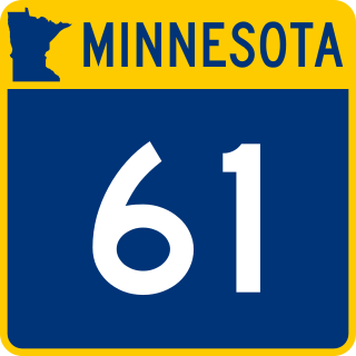
Minnesota State Highway 61 is a 150.321-mile-long (241.918 km) highway in northeast Minnesota, which runs from a junction with Interstate 35 (I-35) in Duluth at 26th Avenue East, and continues northeast to its northern terminus at the Canadian border near Grand Portage, connecting to Ontario Highway 61 at the Pigeon River Bridge. The route is a scenic highway, following the North Shore of Lake Superior, and is part of the Lake Superior Circle Tour designation that runs through Minnesota, Ontario, Michigan, and Wisconsin.

Minnesota State Highway 23 (MN 23) is a state highway that stretches from southwestern to northeastern Minnesota. At 343.723 miles (553.169 km) in length, it is the second longest state route in Minnesota, after MN 1.

New York State Route 94 (NY 94) is a state highway entirely within Orange County in southern New York. The western terminus is at the New York–New Jersey state line, where it continues as New Jersey's Route 94 for another 46 miles (74 km) to Columbia, New Jersey. Its eastern terminus is located at U.S. Route 9W (US 9W) in New Windsor. From Warwick to Florida, NY 94 is concurrent with NY 17A. The entirety of NY 94 is known as the 94th Infantry Division Memorial Highway.
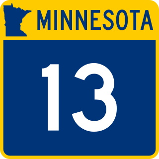
Minnesota State Highway 13 is a 111.694-mile-long (179.754 km) highway in Minnesota that runs from its intersection with U.S. Highway 65 in Albert Lea to its northern terminus at its intersection with State Highway 149 at the West St. Paul / Saint Paul city boundary line.

State Route 26 (abbreviated SR 26) is part of Maine's system of numbered state highways. It is a major interregional route running for 95.90 miles (154.34 km) from downtown Portland northwest to the New Hampshire border near Upton, where it connects to New Hampshire Route 26. SR 26 runs in Cumberland, Androscoggin and Oxford Counties.

Minnesota State Highway 101 is a state highway in the U.S. state of Minnesota. The present day route currently has two separate segments. The roadway was a continuous route until 1988.

New York State Route 259 (NY 259) is a north–south state highway located west of Rochester in Monroe County, New York, in the United States. The southern terminus of the route is at an intersection with NY 33A in the hamlet of West Chili within the town of Chili. Its northern terminus is at a junction with the Lake Ontario State Parkway in Parma near the Lake Ontario shoreline. NY 259 meets Interstate 490 (I-490) in Chili and NY 531 south of Spencerport. The junction with I-490 is less than 0.2 miles (0.3 km) from where NY 259 begins at NY 33A.
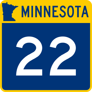
Minnesota State Highway 22 (MN 22) is a 166.325-mile-long (267.674 km) highway in south-central and central Minnesota, which runs from Winnebago County Road R50 at the Iowa state line near Kiester and continues north to its northern terminus at its intersection with State Highway 23 in Richmond, west of St. Cloud.

Minnesota State Highway 4 is a 167.136-mile-long (268.979 km) highway in southwest and west-central Minnesota, which runs from Iowa Highway 4 at the Iowa state line, and continues north to its northern terminus at its interchange with Interstate Highway 94 near Sauk Centre and Melrose.

Minnesota State Highway 238 (MN 238) is a 34.709-mile-long (55.859 km) highway in central Minnesota, which runs from its interchange with Interstate 94 and Stearns County State-Aid Highway 10 in Albany and continues north to its northern terminus at its intersection with State Highways 27 / 28 near Little Falls.

Minnesota State Highway 241 (MN 241) is a 3.531-mile-long (5.683 km) highway in Minnesota, which runs from its intersection with Wright County State-Aid Highway 19 and Wright County State-Aid Highway 35 in St. Michael and continues east to its eastern terminus at its interchange with Interstate 94 and Wright County State-Aid Highway 36 in St. Michael.

Minnesota State Highway 237 (MN 237) is a short 2.754-mile-long (4.432 km) highway in central Minnesota, which runs from its intersection with Stearns County State-Aid Highways 12 and 30 in New Munich and continues north to its northern terminus at its interchange with Interstate 94 and Stearns County State-Aid Highway 65 in Oak Township near Melrose. MN 237 passes through the city of New Munich.

U.S. Highway 169 (U.S. 169) is a major north–south highway in the U.S. state of Minnesota, connecting the Minnesota River valley with the Twin Cities and the Iron Range. Much of the route is built to expressway or freeway standards.
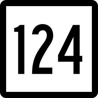
Route 124 is a state highway in southwestern Connecticut running from downtown Darien through the center of New Canaan to the state line in Scotts Corners, New York.

