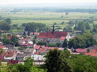
Pińczówpronounced [ˈpʲiɲt͡ʂuf] is a town in Poland, in Świętokrzyskie Voivodeship, about 40 km south of Kielce. It is the capital of Pińczów County. Population is 12,304 (2005). Pińczów belongs to the historic Polish province of Lesser Poland, and lies in the valley of the Nida river. The town has a station on a narrow-gauge line, called Holy Cross Mountains Rail

Mirow is a town in the district of Mecklenburgische Seenplatte in southern Mecklenburg-Vorpommern, Germany.

Iron-Gate Square is a large open space in the city center of Warsaw. The square took its name from a large iron gate that once secured the western boundary of the Saxon Garden.

Mirów is one of the neighbourhoods of the Wola district of Warsaw, Poland. It is limited by the Solidarności, Jana Pawła II, Prosta and Towarowa streets.

Hale Mirowskie is a market constructed in 1899-1901 in Warsaw's Mirów district. Until its destruction during the 1944 Warsaw Uprising, it was Warsaw's largest market. Rebuilt in the 1950s–1960s, it was restored to its original function as a market.
Mirów may refer to the following places in Poland:

Mirów is a village in the administrative district of Gmina Niegowa, within Myszków County, Silesian Voivodeship, in southern Poland. It lies approximately 5 kilometres (3 mi) south of Niegowa, 12 km (7 mi) east of Myszków, and 53 km (33 mi) north-east of the regional capital Katowice.
Mecklenburgische Kleinseenplatte is an Amt in the Mecklenburgische Seenplatte district, in Mecklenburg-Vorpommern, Germany. The seat of the Amt is in Mirow.

Mirów is a village in the administrative district of Gmina Alwernia, within Chrzanów County, Lesser Poland Voivodeship, in southern Poland. It lies approximately 4 kilometres (2 mi) south of Alwernia, 14 km (9 mi) south-east of Chrzanów, and 31 km (19 mi) west of the regional capital Kraków.
Mirów is a village in the administrative district of Gmina Przasnysz, within Przasnysz County, Masovian Voivodeship, in east-central Poland.
Bieszków Dolny is a village in the administrative district of Gmina Mirów, within Szydłowiec County, Masovian Voivodeship, in east-central Poland. It lies approximately 9 kilometres (6 mi) south-east of Szydłowiec and 113 km (70 mi) south of Warsaw.
Bieszków Górny is a village in the administrative district of Gmina Mirów, within Szydłowiec County, Masovian Voivodeship, in east-central Poland. It lies approximately 10 kilometres (6 mi) east of Szydłowiec and 111 km (69 mi) south of Warsaw.
Mirów Nowy is a village in the administrative district of Gmina Mirów, within Szydłowiec County, Masovian Voivodeship, in east-central Poland. It lies approximately 3 kilometres (2 mi) east of Mirów, 16 km (10 mi) east of Szydłowiec, and 113 km (70 mi) south of Warsaw.
Mirówek is a village in the administrative district of Gmina Mirów, within Szydłowiec County, Masovian Voivodeship, in east-central Poland. It lies approximately 4 kilometres (2 mi) north of Mirów, 13 km (8 mi) east of Szydłowiec, and 110 km (68 mi) south of Warsaw.
Rogów is a village in the administrative district of Gmina Mirów, within Szydłowiec County, Masovian Voivodeship, in east-central Poland. It lies approximately 2 kilometres (1 mi) west of Mirów, 13 km (8 mi) east of Szydłowiec, and 113 km (70 mi) south of Warsaw.
Zbijów Duży is a village in the administrative district of Gmina Mirów, within Szydłowiec County, Masovian Voivodeship, in east-central Poland.
Zbijów Mały is a village in the administrative district of Gmina Mirów, within Szydłowiec County, Masovian Voivodeship, in east-central Poland. It lies approximately 15 kilometres (9 mi) south-east of Szydłowiec and 117 km (73 mi) south of Warsaw.
Mirów Castle is a 14th-century castle, now ruined, located in the Mirów village, Silesian Voivodeship, Poland. It changed owners multiple times, and was finally abandoned in 1787.
Thomas Mirow is a German politician of the Social Democratic Party who served as president of the European Bank for Reconstruction and Development from 2008 to 2012.


