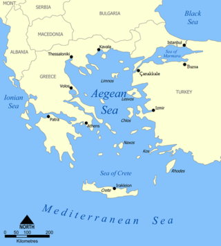
The Aegean Sea is an elongated embayment of the Mediterranean Sea between Europe and Asia. It is located between the Balkans and Anatolia, and covers an area of some 215,000 square kilometres. In the north, the Aegean is connected to the Marmara Sea and the Black Sea by the straits of the Dardanelles and the Bosphorus. The Aegean Islands are located within the sea and some bound it on its southern periphery, including Crete and Rhodes. The sea reaches a maximum depth of 2,639m to the west of Karpathos. The Thracian Sea and the Sea of Crete are main subdivisions of the Aegean Sea.
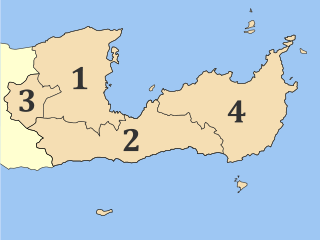
Lasithi is the easternmost regional unit on the island of Crete, to the east of Heraklion. Its capital is Agios Nikolaos, the other major towns being Ierapetra and Sitia. The mountains include the Dikti in the west and the Thrypti in the east. The Sea of Crete lies to the north and the Libyan Sea to the south.

Ierapetra is a Greek city and municipality located on the southeast coast of Crete.
The Sea of Crete, or Cretan Sea, is a sea, part of the Aegean Sea, located in its southern extremity, with a total surface area of 45,000 km2 (17,000 sq mi). The sea stretches to the north of the island of Crete, east of the islands of Kythera and Antikythera, south of the Cyclades, and west of the Dodecanese islands of Rhodes, Karpathos and Kassos. The bounding sea to the west is the Ionian Sea. To the northwest is the Myrtoan Sea, a subdivision of the Mediterranean Sea that lies between the Cyclades and Peloponnese. To the east-southeast is the rest of the Mediterranean Sea, sometimes credited as the Levantine Sea. Across the island of Crete, to the opposite shore of it begins the Libyan Sea. Ferry routes to and from Piraeus and Heraklion, as well as the southern islands of the Aegean and the Dodecanese, run in this area.

Pseira is an islet in the Gulf of Mirabello in northeastern Crete with the archaeological remains of Minoan and Mycenean civilisation.

Mochlos is a modern, populated, and inhabited island in the Gulf of Mirabello in eastern Crete, and the archaeological site of an ancient Minoan settlement. There is evidence that Mochlos was not an island in Minoan times, but was attached to the mainland and acted as an eastern harbor.
Olous or Olus was a city of ancient Crete; now sunken, it was situated at the present day town of Elounda, Crete, Greece. According to the Stadiasmus Maris Magni, it had a harbour and was located 260 stadia from Chersonasus and 15 stadia from Camara.
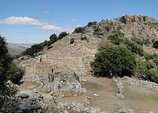
Lato was an ancient city of Crete, the ruins of which are located approximately 3 km from the village of Kritsa.

Souda Bay is a bay and natural harbour near the town of Souda on the northwest coast of the Greek island of Crete. The bay is about 15 km long and only two to four km wide, and a deep natural harbour. It is formed between the Akrotiri peninsula and Cape Drapano, and runs west to east. The bay is overlooked on both sides by hills, with a relatively low and narrow isthmus in the west near Chania.

Kritsa is one of the oldest and most picturesque villages in Crete, Greece, built amphitheatrically on a rock hill, named Kastellos, surrounded by olive groves, at an altitude of 375 m. It is part of the municipality of Agios Nikolaos. During the Middle Ages, it was thought to be the largest village in Crete. Kritsa has been destroyed many times during the last centuries because it participated in all of Crete's revolutions. It is located 10 km from Agios Nikolaos and has about 2200 inhabitants who live in different neighborhoods named Palemilos, Koukistres, Christos and Pergiolikia.
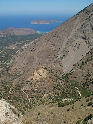
Kavousi is a historic village in the municipality of Ierapetra in the prefecture of Lasithi in eastern Crete. "Kavousi" in the Cretan dialect means "water source". The village is situated 19 km (11.8 mi) northeast of Ierapetra, 26 km (16 mi) east of Agios Nikolaos and 42 km (26 mi) west of Sitia. The village is located in the northern foothills of the Thripti mountain range at an elevation of 140 meters above sea level. Many archaeological sites have been discovered in the area of Kavousi, among which are Vronda, Kastro, Azoria, Chrysokamino and the isle Pseira. Kavousi lies just 3.6 km (2.2 mi) south of Tholos Beach. The village has views over the Gulf of Mirabello and the Isthmus of Ierapetra.
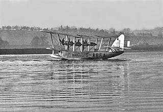
The Short S.17 Kent was a British four-engined 15-seat biplane luxury flying boat airliner, designed and built by Shorts to meet a requirement from Imperial Airways for an aircraft with greater range than the Short Calcutta. The new aircraft was to have sufficient range to fly the stage from Mirabella, Crete, to Alexandria in Egypt without the need for refuelling stops in Italian colonial territory due to a political row which had led the Italian Government to ban British aircraft from its ports.

Aptera or Apteron was an ancient city, now an archaeological site in western Crete, a kilometre inland from the southern shore of Souda Bay, about 13 km east of Chania in the municipality of Akrotiri.

Polyrrhenia or Polyrrenia, Polyrrhen or Polyrren (Πολύρρην) or Polyren (Πολύρην), or Pollyrrhenia or Pollyrrenia (Πολλύρρηνα), or Polyrrenion (Πολυρρήνιον) or Polyrrhenium, was a town and polis (city-state) in the northwest of ancient Crete, whose territory occupied the whole western extremity of the island, extending from north to south. It was an important Archaic Period settlement co-temporaneous with Lato and Prinias. Strabo describes it as lying west of Cydonia, at the distance of 30 stadia from the sea, and 60 from Phalasarna, and as containing a temple of Dictynna. He adds that the Polyrrhenians formerly dwelt in villages, and that they were collected into one place by the Achaeans and Lacedaemonians, who built a strong city looking towards the south. In the civil wars in Crete in the time of the Achaean League, 219 BCE, the Polyrrhenians, who had been subject allies of Cnossus, deserted the latter, and assisted the Lyctians against that city. They also sent auxiliary troops to the assistance of the Achaeans, because the Cnossians had supported the Aetolians. In a successful campaign they prevented their rival cities Cnossus and Gortys from dominating the entire island and brought a large part over to the Macedonian coalition. Polyrrhenia continued to flourish in the Roman period, when the center shifted to its erstwhile port, Cisamus, and in this urbanistic configuration lasted into Byzantine times. A small town now occupies the site, where rock-cut tombs, ruins and an acropolis remain. A Roman aqueduct built in the age of Hadrian improved water supplies.
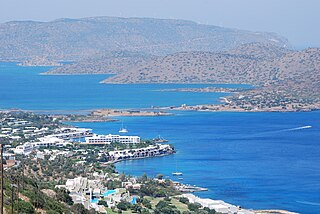
Elounda, alternatively transliterated as Elounta or Elouda, is a small town on the northern coast of the island of Crete, Greece. It is part of the municipality of Agios Nikolaos.

Eleutherna, also called Apollonia (Greek: Ἀπολλωνία), was an ancient city-state in Crete, Greece, which lies 25 km southeast of Rethymno in Rethymno regional unit. Archaeologists excavated the site, located on a narrow northern spur of Mount Ida, the highest mountain in Crete. The site is about 1 km south of modern town of Eleftherna, about 8 km north east of Moni Arkadiou, in the current municipality of Rethymno. It flourished from the Dark Ages of Greece’s early history until Byzantine times.

Priniatikos Pyrgos is an archaeological site near Istron River, in the eastern Cretan regional unit of Lasithi, (Greece). The nearest big town is Agios Nikolaos, Crete. The site is on a coastal promontory. It appears to have been first settled in the Final Neolithic, circa 3000 BC. Nearby, there's a small resort town of Kalo Chorio, Lasithi. It is not to be confused with Myrtos Pyrgos on the south coast.
Hyrtacina or Hyrtakina, also written as Hyrsacina or Hyrsakina (Ὑρσακίνα), or Artacina or Artakina (Ἀρτάκινα), was a city of ancient Crete, which, little as we learn of its position from Ptolemy and Stephanus of Byzantium, yet we may safely infer from the former's words that it was situated to the southeast of Polyrrhenia, and to the west of Lappa. The Periplus of Pseudo-Scylax teaches us more respecting its site; it places it on the south of the island, and to the south of the Dictynnean temple of Artemis and the Pergamian district. These indications agree well with the situation of the ruins discovered by Robert Pashley on Kastri hill between the existing villages Temenia and Papadiana.
Azoria is an archaeological site on a double-peaked hill overlooking the Gulf of Mirabello in eastern Crete in the Greek Aegean. "Azoria" is a local toponym, not apparently an ancient place name or epigraphically-attested Greek city.

The Isthmus of Ierapetra is a strip of land on the Greek island of Crete which connects the easternmost municipality, Siteia, to the rest of the island. Its name comes from the largest settlement, Ierapetra (Ιεράπετρα), which is situated on the south coast.


