
Capitol Reef National Park is an American national park in south-central Utah. The park is approximately 60 miles (97 km) long on its north–south axis and just 6 miles (9.7 km) wide on average. The park was established in 1971 to preserve 241,904 acres of desert landscape and is open all year, with May through September being the highest visitation months.

Great Sand Dunes National Park and Preserve is an American national park that conserves an area of large sand dunes up to 750 feet (230 m) tall on the eastern edge of the San Luis Valley, and an adjacent national preserve in the Sangre de Cristo Range, in south-central Colorado, United States. The park was originally designated Great Sand Dunes National Monument on March 17, 1932, by President Herbert Hoover. The original boundaries protected an area of 35,528 acres. A boundary change and redesignation as a national park and preserve was authorized on November 22, 2000, and then established on September 24, 2004. The park encompasses 107,342 acres while the preserve protects an additional 41,686 acres for a total of 149,028 acres. The recreational visitor total was 527,546 in 2019.

San Gorgonio Mountain, also known locally as Mount San Gorgonio, or Old Greyback, is the highest peak in Southern California and the Transverse Ranges at 11,503 feet (3,506 m).

The Simi Hills are a low rocky mountain range of the Transverse Ranges in eastern Ventura County and western Los Angeles County, of southern California, United States.

Cleveland National Forest encompasses 460,000 acres, mostly of chaparral, with a few riparian areas. A warm dry mediterranean climate prevails over the forest. It is the southernmost U.S. National Forest of California. It is administered by the U.S. Forest Service, a government agency within the United States Department of Agriculture. It is divided into the Descanso, Palomar and Trabuco Ranger Districts and is located in the counties of San Diego, Riverside, and Orange.

The San Diego River is a river in San Diego County, California. It originates in the Cuyamaca Mountains northwest of the town of Julian, then flows to the southwest until it reaches the El Capitan Reservoir, the largest reservoir in the river's watershed at 112,800 acre-feet (139,100,000 m3). Below El Capitan Dam, the river runs west through Santee and San Diego. While passing through Tierrasanta it goes through Mission Trails Regional Park, one of the largest urban parks in America.

The San Gorgonio Wilderness is located in the eastern San Bernardino Mountains, in San Bernardino County and into northern Riverside County, Southern California.

The San Gorgonio Pass, or Banning Pass, is a 2,600 ft (790 m) elevation gap on the rim of the Great Basin between the San Bernardino Mountains to the north and the San Jacinto Mountains to the south. The pass was formed by the San Andreas Fault, a major transform fault between the Pacific plate and the North American plate. The tall mountain ranges on either side of the pass result in the pass being a transitional zone from a Mediterranean climate west of the pass, to a Desert climate east of the pass. This also makes the pass area one of the windiest places in the United States, and why it is home to the San Gorgonio Pass wind farm.

The Santa Rosa and San Jacinto Mountains National Monument is a National Monument in southern California. It includes portions of the Santa Rosa and San Jacinto mountain ranges, the northernmost ones of the Peninsular Ranges system. The national monument covers portions of Riverside County, west of the Coachella Valley, approximately 100 miles (160 km) southeast of downtown Los Angeles.

The Morongo Basin is an endorheic basin and valley region located in eastern San Bernardino County, in Southern California.

The Big Morongo Canyon Preserve is a 31,000-acres (130 km2) native plants habitat and wildlife preserve located in the Little San Bernardino Mountains of the Transverse Ranges, in the transition zone between the higher Mojave Desert and lower elevation Colorado Desert section of the Sonoran Desert. Due to its location within this transition zone, the area is especially high in natural diversity. The natural spring fed desert oasis found here is one of the 10 largest Cottonwood and Willow riparian habitats in California. It is also identified by the Audubon Society as one of the most important avian habitat areas in California.
The Whitewater River is a small permanent stream in western Riverside County, California, with some upstream tributaries in southwestern San Bernardino County. The river's headwaters are in the San Bernardino Mountains and it terminates at the Salton Sea in the Colorado Desert. The area drained by the Whitewater River is part of the larger endorheic Salton Sea drainage basin.
Mission Point, better known as "Mission Peak" to locals, is a spur of Oat Mountain in Los Angeles County, Southern California. At 2,771 feet (845 m) high, it is the second highest peak of the Santa Susana Mountains after Oat Mountain.

Whitewater is a census-designated place in Riverside County, California. It is directly off Interstate 10 halfway between North Palm Springs and Cabazon on the way from Palm Springs to Los Angeles. It is known as the site of the San Gorgonio Pass Wind Farm. The ZIP Code is 92282, and the community is inside area code 760. The population was 859 at the 2010 census. The elevation is 1,575 feet (480 m).

San Timoteo Canyon is a river valley canyon southeast of Redlands, in the far northwestern foothills of the San Jacinto Mountains in the Inland Empire region of Southern California.
The Wildlands Conservancy (TWC) is a nonprofit organization whose mission is to preserve land for public recreation. It operates 22 preserves in California. The preserve system comprises 180,686 acres including mountains, valleys, deserts, rivers and oceanfront lands. TWC buys land, restores land, builds public visitor facilities and provides outdoor education programs for children. All usage is free of charge. There are over 1 million visitors annually.

Sand to Snow National Monument is a U.S. National Monument located in San Bernardino County and northern Riverside County, Southern California.

Pioneertown Mountains Preserve is a Wildlands Conservancy nature preserve, showcasing geologically interesting mountain ranges and riparian zones. It is located in the Mojave Desert in the eastern San Bernardino Mountains.
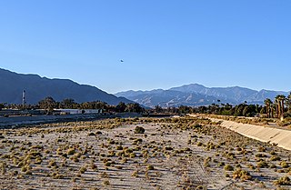
Whitewater Preserve is a Wildlands Conservancy nature preserve, showcasing the perennial Whitewater River flowing through a desert canyon. The preserve is located within the San Bernardino Mountains and is part of the Sand to Snow National Monument.
Wind Wolves Preserve is a Wildlands Conservancy nature preserve, within the San Emigdio Mountains. It is the largest non-profit nature preserve on the west coast.
