Related Research Articles

The Pennyroyal Plateau is a large area of Kentucky that features rolling hills, caves, and karst topography in general. It is named for a wild mint that grows in the area. It is also called the "Mississippian Plateau," for the Mississippian geologic age in which it was formed.
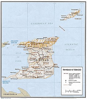
The Northern Range is the range of tall hills across north Trinidad, the major island in the Republic of Trinidad and Tobago. The hills range from the Chaguaramas peninsula on the west coast to Toco in the east. The Northern Range covers approximately twenty-five percent of the land area of Trinidad.

Bluespring Caverns is a cave system located in Lawrence County, Indiana, approximately 80 miles (128 km) south of Indianapolis. The cave system is a karst and river type cave formation and drains a 15 miles² (38.8 km²) sinkhole plain. The cave contains 21 miles (34 km) of surveyed passages and is most notable for having the longest known subterranean river in the United States with approximately 3 miles (4.8 km) of navigable river.

Monte Grappa is a mountain of the Venetian Prealps in Veneto, Italy. It lies between the Venetian plain to the south and the central alpine areas to the North. To the west, it is parted from the Asiago upland by the Brenta river, and to the east it is separated from the Cesen-Visentin massif by the Piave river. To the north lie Corlo lake and Feltre valley. In the past, the mountain was called Alpe Madre, and is currently divided among three provinces: Vicenza to the west, Treviso to the south and Belluno to the northeast. It is the highest peak of a small massif, which also includes many other peaks such as Col Moschin, Colle della Berretta, Monte Asolone, Monte Pertica, Prassolan, Monti Solaroli, Fontana Secca, Monte Peurna, Monte Santo, Monte Tomatico, Meatte, Monte Pallon and Monte Tomba.
The Indiana Uplands are a geographical region in south-central Indiana. On a topographical map the Indiana Uplands begin slightly north of the city of Martinsville, Indiana and continue south to the Ohio River. The description of the region inspired the name of Upland Brewing Company. The region's approximate boundaries are Interstate 65 to the east and U.S. Route 231 to the west. The Uplands are characterized by rolling hills composed of sandstone, limestone, and siltstone from West to east. The siltstone hills are the most rugged followed by the sandstone while the limestone are the smoothest. This is contrast to the Tipton Till Plain immediately to the north in central Indiana, which features flat to gently rolling landscape.

Carboniferous Limestone is a collective term for the succession of limestones occurring widely throughout Great Britain and Ireland that were deposited during the Dinantian Epoch of the Carboniferous Period. These rocks formed between 363 and 325 million years ago. Within England and Wales, the entire limestone succession, which includes subordinate mudstones and some thin sandstones, is known as the Carboniferous Limestone Supergroup.
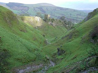
Cave Dale is a dry limestone valley in the Derbyshire Peak District, England. It is located at grid reference SK149824. The northern end of the dale starts at the village of Castleton where the valley sides are almost perpendicular and over 50 metres in height. The dale rises gently after leaving Castleton for approximately 200 metres before becoming steeper culminating in a fine viewpoint down the dale taking in Peveril Castle with Lose Hill behind. After the viewpoint the dale swings west and levels out with gentle gradients, becoming just a shallow depression as it peters out onto the open pastureland between Castleton and Chapel-en-le-Frith.
The Knobstone Escarpment is a rugged geologic region in Southern Indiana. Physically, the Knobstone Escarpment is the most rugged terrain in Indiana. The highest hill in the area is Weed Patch Hill, with an elevation of 1,060 feet above sea level.

The Geology of Pennsylvania consists of six distinct physiographic provinces, three of which are subdivided into different sections. Each province has its own economic advantages and geologic hazards and plays an important role in shaping everyday life in the state. They are: the Atlantic Coastal Plain Province, the Piedmont Province, the New England Province, the Ridge and Valley Province, the Appalachian Plateau Province, and the Central Lowlands Province.

The mountains and hills of England comprise very different kinds of terrain, from a mountain range which reaches almost 1,000 metres high, to several smaller areas of lower mountains, foothills and sea cliffs. Most of the major upland areas have been designated as Areas of Outstanding Natural Beauty (AONB) or national parks. The highest and most extensive areas are in the north and west, while the south-east and east of the country tend to be low-lying. The Lake District is near the coast and is famous for collecting precious gems.

The Kraków-Częstochowa Upland, also known as the Polish Jurassic Highland or Polish Jura, is part of the Jurassic System of south–central Poland, stretching between the cities of Kraków, Częstochowa and Wieluń. The Polish Jura borders the Lesser Polish Upland to the north and east, the foothills of the Western Carpathians to the south and Silesian Upland to the west.

Perry Township is one of eleven townships in Monroe County, Indiana, United States. As of the 2010 census, its population was 50,673 and it contained 24,194 housing units.
The Lost River is a river that rises in Vernon Township, Washington County, Indiana, and discharges into the East Fork of the White River in Lost River Township, Martin County, Indiana. The river's unusual hydrology has led to two of its features being named as National Natural Landmarks.

The Kankakee Outwash Plain is a flat plain interspersed with sand dunes in the Kankakee River valley in northwestern Indiana and northeastern Illinois of the United States. It is just south of the Valparaiso Moraine and was formed during the Wisconsin Glaciation. As the glacier, stopped at the Valparaiso Moraine, melted, the meltwater was carried away to the outwash plain. On the south side of the moraine, where the elevation drops, the meltwaters eroded away valleys, carrying sand and mud with them. As the muddy meltwater reached the valley where the slope lessened, the water slowed down, depositing the sand on the outwash plain. This created a smooth, flat, and sandy plain. Before its draining, the Kankakee Marsh, located on the outwash plain, was one of the largest freshwater marshes in the United States.
The Caves of the Tullybrack and Belmore hills can be found in south-west County Fermanagh, Northern Ireland. The region is also described as the West Fermanagh Scarplands by environmental agencies and shares many similar karst features with the nearby Marble Arch Caves Global Geopark.
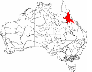
The Einasleigh Uplands is an interim Australian bioregion, with vegetation consisting of savanna and woodland located on a large plateau in inland Queensland, Australia.

The Interior Low Plateaus are a physiographic region in eastern United States. It consists of a diverse landscape that extends from north Alabama across central Tennessee and Kentucky into southern Illinois, Indiana, and Ohio. Its natural communities are a matrix of temperate forests, woodlands, and prairies.
American River is a waterway in the U.S. state of Alaska. Situated on the northwestern portion of Seward Peninsula, it is the eastern and larger fork of the Agiapuk River. It joins the Agiapuk River in a broad, gravel-filled basin, and for 20 miles (32 km) up, is characterized by a wide flood plain and a meandering course. It receives a number of large tributaries from the east, which also have wide floodplains developed in their lower parts. The important tributaries are Portage Creek, Budd Creek, and Igloo Creek, while smaller tributaries are Burke, Gold Run, Dome, and Camp creeks. All of these tributaries received some attention from gold prospectors. The river is easily navigable for small boats for several miles above the mouth of Portage Creek, and the region can also be reached from Teller. Gold had been discovered in the region in September 1901, and a number of the streams were known to be gold-bearing to some extent.

Indiana Caverns is part of the Binkley Cave system near Corydon, Indiana.
References
Coordinates: 38°25′N86°10′W / 38.417°N 86.167°W
| This article about a specific United States geological feature is a stub. You can help Wikipedia by expanding it. |