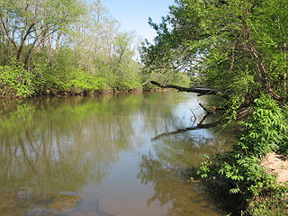
The Yadkin River is one of the longest rivers in the US state of North Carolina, flowing 215 miles (346 km). It rises in the northwestern portion of the state near the Blue Ridge Parkway's Thunder Hill Overlook. Several parts of the river are impounded by dams for water, power, and flood control. The river becomes the Pee Dee River at the confluence of the Uwharrie River south of the community of Badin and east of the town of Albemarle. The river then flows into South Carolina near Cheraw, which is at the Fall Line. The entirety of the Yadkin River and the Great Pee Dee River is part of the Yadkin-Pee Dee River Basin.

The Uwharrie River () is a 61.84 mi (99.52 km) long river, in the Piedmont region of central North Carolina in the United States. It is a tributary of the Pee Dee River, which flows to the Atlantic Ocean.
The First Broad River is a tributary of the Broad River, about 60 mi (95 km) long in western North Carolina in the United States. Via the Broad and Congaree Rivers, it is part of the watershed of the Santee River, which flows to the Atlantic Ocean.
The Second Broad River is a tributary of the Broad River in western North Carolina in the United States. Via the Broad and Congaree rivers, it is part of the watershed of the Santee River, which flows to the Atlantic Ocean.

The Shenango River is a principal tributary of the Beaver River, approximately 100 mi (160 km) long, in western Pennsylvania in the United States. It also briefly flows through small portions of northeastern Ohio. Via the Beaver and Ohio Rivers, it is part of the watershed of the Mississippi River.
The Roaring River is a tributary of the Yadkin River in northwestern North Carolina in the United States. Via the Yadkin it is part of the watershed of the Pee Dee River, which flows to the Atlantic Ocean. According to the Geographic Names Information System, it has also been known historically as "Roaring Creek." The river's name comes from its headwaters in the Blue Ridge Mountains, where it flows through a series of small waterfalls.
The Reddies River is a tributary of the Yadkin River in northwestern North Carolina in the United States. Via the Yadkin it is part of the watershed of the Pee Dee River, which flows to the Atlantic Ocean. According to the Geographic Names Information System, it has also been known historically as "Reddis River."
The Fisher River is a tributary of the Yadkin River in northwestern North Carolina in the United States, also draining a very small portion of southwestern Virginia. Via the Yadkin it is part of the watershed of the Pee Dee River, which flows to the Atlantic Ocean. According to the Geographic Names Information System, it has also been known historically as "Big Fishers River," "Fish River" and "Fishe River."
The Ararat River is a tributary of the Yadkin River in southwestern Virginia and northwestern North Carolina in the United States. Via the Yadkin it is part of the watershed of the Pee Dee River, which flows to the Atlantic Ocean.

The Mayo River is a tributary of the Dan River, which in turn is a tributary of the Roanoke River. All three rivers flow through the U.S. states of Virginia and North Carolina. It is named for Major William Mayo.
Reedy Fork is a 43.70 mi (70.33 km) long 3rd order tributary to the Haw River, in Alamance County, North Carolina.
Jacob Fork is a 41.09-mile (66.13 km) long, fourth-order tributary of the South Fork Catawba River in Burke and Catawba Counties, North Carolina. According to the Geographic Names Information System, it has also been known historically as Jacobs Creek.
Johnson Creek is a 10.71 mi (17.24 km) long 2nd order tributary to the Ararat River in Surry County, North Carolina.
Faulkner Creek is a 5.98 mi (9.62 km) long 2nd order tributary to the Ararat River in Surry County, North Carolina.
Lovills Creek is a 17.24 mi (27.75 km) long 3rd order tributary to the Ararat River in Surry County, North Carolina. This is the only stream of this name in the United States.
Stewarts Creek is a 20.24 mi (32.57 km) long 4th order tributary to the Ararat River in Surry County, North Carolina.
Beaver Creek is a 5.51 mi (8.87 km) long 2nd order tributary to the Fisher River in Surry County, North Carolina.
Elkin Creek is a 3.91 mi (6.29 km) long 4th order tributary to the Yadkin River in Surry and Wilkes Counties, North Carolina. This is the only stream of this name in the United States.
Grassy Creek is a 4.62 mi (7.44 km) long 2nd order tributary to Elkin Creek in Wilkes and Surry Counties, North Carolina.
Little Elkin Creek is a 9.27 mi (14.92 km) long 3rd order tributary to the Yadkin River in Wilkes County, North Carolina.


