Related Research Articles

Breckland is a local government district in Norfolk, England. Its council is based in Dereham, although the largest town is Thetford. The district also includes the towns of Attleborough, Swaffham and Watton, along with numerous villages and surrounding rural areas.

The Diocese of Norwich, formerly known as the Diocese of the East Angles, East Anglia, Elmham, and Thetford, is an ecclesiastical jurisdiction or diocese of the Church of England that forms part of the Province of Canterbury in England.

Mid Norfolk is a constituency represented in the House of Commons of the UK Parliament since 2010 by George Freeman, a Conservative.

Gateley is a village and civil parish in the Breckland district of Norfolk, England.

Litcham is a village and civil parish in the English county of Norfolk. It is situated some 10 km (6.2 mi) north-east of the town of Swaffham and 40 km (25 mi) west of the city of Norwich. The village is located on the B1145 a route which runs between King's Lynn and Mundesley.

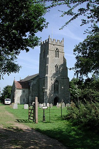
Round-tower churches are a type of church found mainly in England, mostly in East Anglia; of about 185 surviving examples in the country, 124 are in Norfolk, 38 in Suffolk, six in Essex, three in Sussex and two each in Cambridgeshire and Berkshire. There is evidence of about 20 round-tower churches in Germany, of similar design and construction to those in East Anglia. Countries with at least one round-tower church include Andorra, the Czech Republic, Denmark, France, Italy, Sweden, Norway, Poland and South Africa.

Twyford is a hamlet and civil parish in the English county of Norfolk. It is situated on the A1067 road, some 12 km (7.5 mi) south-east of the town of Fakenham and 28 km (17 mi) north-west of the city of Norwich.

East Lexham is a village and former civil parish, now in the parish of Lexham, in the Breckland district, in the English county of Norfolk. It is 7.7 miles (12.4 km) north of the town of Swaffham, 30.1 miles (48.4 km) west north west of Norwich and 106 miles (171 km) north east of London. In 1931 the parish had a population of 160.

The A1065 is a main road in the English region of East Anglia. It provides the principal road connection to parts of the west and north of the county of Norfolk from Newmarket and points south of there, including London. It runs from a junction near Mildenhall, to a junction on the western outskirt of Fakenham.
North Tuddenham is a civil parish in the English county of Norfolk, North Tuddenham is 3 miles (4.8 km) east of East Dereham, and is close to the A47 road.

Great Fransham is a village and former civil parish in the Breckland district, in the county of Norfolk, England, roughly about an equal distance between Swaffham and Dereham. There is also a Little Fransham; the two villages, both now part of the parish of Fransham, were once served by Fransham railway station. In 1931 the parish had a population of 222. On 1 April 1935 the parish was abolished and merged to form Fransham.
Fransham railway station is a former station in Great Fransham, Norfolk. It was opened as part of the Lynn and Dereham Railway, becoming part of the East Anglian Railway from 1847, on the section of line between Dereham and Swaffham.

Newton by Castle Acre is a village, Anglican parish and civil parish in the Breckland district of the English county of Norfolk. It is situated on the A1065 Mildenhall to Fakenham road, about 4 miles (6.4 km) north of the town of Swaffham. The village is 28 miles (45 km) from the city of Norwich and 103 miles (166 km) from London.

East Tuddenham is a village in the English county of Norfolk. The village is located 5.6 miles (9.0 km) south-west of Dereham and 9.5 miles (15.3 km) north-west of Norwich and is bisected by the A47 between Birmingham and Lowestoft.

Fransham is a civil parish in the Breckland District of the English county of Norfolk; it covers an area of 12.14 km2 (4.7 sq mi), and includes the villages of Great and Little Fransham and the hamlet of Crane's End. Fransham has an estimated population of 430 as of 2007. It lies 6 miles (9.7 km) east from Swaffham and 6+1⁄2 miles (10.5 km) west from Dereham.

Little Dunham is a village situated in the Breckland District of Norfolk and covers an area of 749 hectares with a population of 309 at the 2001 census. The village lies 1+1⁄2 miles (2.4 km) south of its sister village Great Dunham and 6 miles (10 km) by road north east from Swaffham.
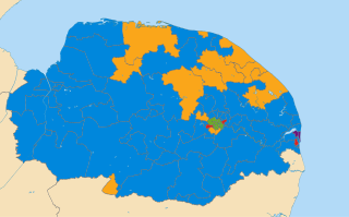
The Norfolk County Council election took place on 4 June 2009, coinciding with local elections for all county councils in England.