Mitigation of seismic motion

Last updated

Mitigation of seismic motion is an important factor in earthquake engineering and construction in earthquake-prone areas. The destabilizing action of an earthquake on constructions may be direct (seismic motion of the ground) or indirect (earthquake-induced landslides, liquefaction of the foundation soils and waves of tsunami).

Earthquake engineering interdisciplinary branch of engineering

Earthquake engineering is an interdisciplinary branch of engineering that designs and analyzes structures, such as buildings and bridges, with earthquakes in mind. Its overall goal is to make such structures more resistant to earthquakes. An earthquake engineer aims to construct structures that will not be damaged in minor shaking and will avoid serious damage or collapse in a major earthquake. Earthquake engineering is the scientific field concerned with protecting society, the natural environment, and the man-made environment from earthquakes by limiting the seismic risk to socio-economically acceptable levels. Traditionally, it has been narrowly defined as the study of the behavior of structures and geo-structures subject to seismic loading; it is considered as a subset of structural engineering, geotechnical engineering, mechanical engineering, chemical engineering, applied physics, etc. However, the tremendous costs experienced in recent earthquakes have led to an expansion of its scope to encompass disciplines from the wider field of civil engineering, mechanical engineering, nuclear engineering, and from the social sciences, especially sociology, political science, economics, and finance.

Construction Process of the building or assembling of a building or infrastructure

Construction is the process of constructing a building or infrastructure. Construction differs from manufacturing in that manufacturing typically involves mass production of similar items without a designated purchaser, while construction typically takes place on location for a known client. Construction as an industry comprises six to nine percent of the gross domestic product of developed countries. Construction starts with planning, design, and financing; it continues until the project is built and ready for use.

Landslide type of natural disaster, geological phenomenon

The term landslide or less frequently, landslip, refers to several forms of mass wasting that include a wide range of ground movements, such as rockfalls, deep-seated slope failures, mudflows, and debris flows. Landslides occur in a variety of environments, characterized by either steep or gentle slope gradients, from mountain ranges to coastal cliffs or even underwater, in which case they are called submarine landslides. Gravity is the primary driving force for a landslide to occur, but there are other factors affecting slope stability that produce specific conditions that make a slope prone to failure. In many cases, the landslide is triggered by a specific event, although this is not always identifiable.

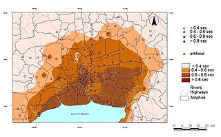
Knowledge of local amplification of the seismic motion from the bedrock is very important in order to choose the suitable design solutions. Local amplification can be anticipated from the presence of particular stratigraphic conditions, such as soft soil overlapping the bedrock, or where morphological settings (e.g. crest zones, steep slopes, valleys, or endorheic basins) may produce focalization of the seismic event.

Amplifier electronic device that can increase the power of a signal

An amplifier, electronic amplifier or (informally) amp is an electronic device that can increase the power of a signal. It is a two-port electronic circuit that uses electric power from a power supply to increase the amplitude of a signal applied to its input terminals, producing a proportionally greater amplitude signal at its output. The amount of amplification provided by an amplifier is measured by its gain: the ratio of output voltage, current, or power to input. An amplifier is a circuit that has a power gain greater than one.

Bedrock Lithified rock under the regolith

Bedrock in geology is the lithified rock that lies under loose softer material called regolith within the surface of the Earth's crust or other terrestrial planets.

The identification of the areas potentially affected by earthquake-induced landslides and by soil liquefaction can be made by geological survey and by analysis of historical documents. Even quiescent and stabilized landslide areas may be reactivated by severe earthquake. [1] Young soil may be particularly susceptible to liquefaction.

Soil liquefaction

Soil liquefaction occurs when a saturated or partially saturated soil substantially loses strength and stiffness in response to an applied stress such as shaking during an earthquake or other sudden change in stress condition, in which material that is ordinarily a solid behaves like a liquid.

See also

Seismic hazard probability that an earthquake will occur in a given geographic area, within a given window of time

A seismic hazard is the probability that an earthquake will occur in a given geographic area, within a given window of time, and with ground motion intensity exceeding a given threshold. With a hazard thus estimated, risk can be assessed and included in such areas as building codes for standard buildings, designing larger buildings and infrastructure projects, land use planning and determining insurance rates. The seismic hazard studies also may generate two standard measures of anticipated ground motion, both confusingly abbreviated MCE; the simpler probabilistic Maximum Considered Earthquake, used in standard building codes, and the more detailed and deterministic Maximum Credible Earthquake incorporated in the design of larger buildings and civil infrastructure like dams or bridges. It is important to clarify which MCE is being discussed.

Tuned mass damper

A tuned mass damper (TMD), also known as a harmonic absorber or seismic damper, is a device mounted in structures to reduce the amplitude of mechanical vibrations. Their application can prevent discomfort, damage, or outright structural failure. They are frequently used in power transmission, automobiles, and buildings.

Vibration control

In earthquake engineering, vibration control is a set of technical means aimed to mitigate seismic impacts in building and non-building structures.

Related Research Articles

The Modified Mercalli intensity scale, descended from Giuseppe Mercalli's Mercalli intensity scale of 1902, is a seismic intensity scale used for measuring the intensity of shaking produced by an earthquake. It measures the effects of an earthquake at a given location, distinguished from the earthquake's inherent force or strength as measured by seismic magnitude scales. While shaking is driven by the seismic energy released by an earthquake, earthquakes differ in how much of their energy is radiated as seismic waves. Deeper earthquakes also have less interaction with the surface, and their energy is spread out across a larger area. Shaking intensity is localized, generally diminishing with distance from the earthquake's epicenter, but can be amplified in sedimentary basins and certain kinds of unconsolidated soils.

Urban seismic risk

Urban seismic risk is a subset of the general term seismic risk which describes the problems specific to centers of population when they are subjected to earthquakes. Many risks can be minimized with good earthquake construction, and seismic analysis. One of the best ways to deal with the issue is through an earthquake scenario analysis.

Geologic hazards

A geologic hazard is one of several types of adverse geologic conditions capable of causing damage or loss of property and life. These hazards consist of sudden phenomena and slow phenomena:

Seismic retrofit Modification of existing structures to make them more resistant to seismic activity

Seismic retrofitting is the modification of existing structures to make them more resistant to seismic activity, ground motion, or soil failure due to earthquakes. With better understanding of seismic demand on structures and with our recent experiences with large earthquakes near urban centers, the need of seismic retrofitting is well acknowledged. Prior to the introduction of modern seismic codes in the late 1960s for developed countries and late 1970s for many other parts of the world, many structures were designed without adequate detailing and reinforcement for seismic protection. In view of the imminent problem, various research work has been carried out. State-of-the-art technical guidelines for seismic assessment, retrofit and rehabilitation have been published around the world – such as the ASCE-SEI 41 and the New Zealand Society for Earthquake Engineering (NZSEE)'s guidelines. These codes must be regularly updated; the 1994 Northridge earthquake brought to light the brittleness of welded steel frames, for example.

Induced seismicity refers to typically minor earthquakes and tremors that are caused by human activity that alters the stresses and strains on the Earth's crust. Most induced seismicity is of a low magnitude. A few sites regularly have larger quakes, such as The Geysers geothermal plant in California which averaged two M4 events and 15 M3 events every year from 2004 to 2009.

Paleoliquefaction is any liquefaction features attributed to seismic events occurring before measurements or written records were kept of earthquakes. The study of these features can reveal a great deal about the seismicity of regions where large earthquakes happen infrequently. This is a subset of the broader field of paleoseismology.

The Seismic Hazard Mapping Act was enacted by the California legislature in 1990 following the Loma Prieta earthquake of 1989. The Act requires the California State Geologist to create maps delineating zones where data suggest amplified ground shaking, liquefaction, or earthquake-induced landsliding may occur.

Ground–structure interaction consists of the interaction between soil (ground) and a structure built upon it. It is primarily an exchange of mutual stress, whereby the movement of the ground-structure system is influenced by both the type of ground and the type of structure. This is especially applicable to areas of seismic activity. Various combinations of soil and structure can either amplify or diminish movement and subsequent damage. A building on stiff ground rather than deformable ground will tend to suffer greater damage. A second interaction effect, tied to mechanical properties of soil, is the sinking of foundations, worsened by a seismic event. This phenomenon is called soil liquefaction.

Causes of landslides

The causes of landslides are usually related to instabilities in slopes. It is usually possible to identify one or more landslide causes and one landslide trigger. The difference between these two concepts is subtle but important. The landslide causes are the reasons that a landslide occurred in that location and at that time. Landslide causes are listed in the following table, and include geological factors, morphological factors, physical factors and factors associated with human activity.

Seismic microzonation

Seismic microzonation is defined as the process of subdividing a potential seismic or earthquake prone area into zones with respect to some geological and geophysical characteristics of the sites such as ground shaking, liquefaction susceptibility, landslide and rock fall hazard, earthquake-related flooding, so that seismic hazards at different locations within the area can correctly be identified. Microzonation provides the basis for site-specific risk analysis, which can assist in the mitigation of earthquake damage. In most general terms, seismic microzonation is the process of estimating the response of soil layers under earthquake excitations and thus the variation of earthquake characteristics on the ground surface.

1964 Niigata earthquake June 1964 earthquake in Japan

The 1964 Niigata earthquake struck at 13:01 local time on 16 June with a magnitude of either 7.5 or 7.6. The epicenter was on the continental shelf off the northwest coast of Honshu, Japan in Niigata Prefecture, about 50 kilometres (31 mi) north of the city of Niigata. The earthquake caused liquefaction over large parts of the city.

1935 Helena earthquake

The 1935 Helena earthquake occurred at 22:48:02 MDT on October 18 in Montana, with an epicenter near Helena. It had a magnitude of 6.2 on the surface wave magnitude scale and a maximum perceived intensity of VIII (Severe) on the Mercalli intensity scale. The temblor on that date was the largest of a series of earthquakes that also included a large aftershock on October 31 of magnitude 6.0 and a maximum intensity of VIII. Two people died in the mainshock and two others died as a result of the October 31 aftershock. Property damage was over $4 million.

Earthquake environmental effects

Earthquake environmental effects are the effects caused by an earthquake, including surface faulting, tsunamis, soil liquefactions, ground resonance, landslides and ground failure, either directly linked to the earthquake source or provoked by the ground shaking. These are common features produced both in the near and far fields, routinely recorded and surveyed in recent events, very often remembered in historical accounts and preserved in the stratigraphic record (paleoearthquakes). Both surface deformation and faulting and shaking-related geological effects not only leave permanent imprints in the environment, but also dramatically affect human structures. Moreover, underwater fault ruptures and seismically-triggered landslides can generate tsunami waves.

Seismic site effects are related to the amplification of seismic waves in superficial geological layers. The surface ground motion may be strongly amplified if the geological conditions are unfavorable. Therefore, the study of local site effects is an important part of the assessment of strong ground motions, seismic hazard and engineering seismology in general. Damage due to an earthquake may thus be aggravated as in the case of the 1985 Mexico City earthquake. For alluvial basins, we may shake a bowl of jelly to model the phenomenon at a small scale.

Seismic intensity scales categorize the intensity or severity of ground shaking (quaking) at a given location, such as resulting from an earthquake. They are distinguished from seismic magnitude scales, which measure the magnitude or overall strength of an earthquake, which may, or perhaps not, cause perceptible shaking.

Olancha Earthquake Sequence (2009)

The Olancha Earthquake Sequence (2009) was a consecutive series of three earthquakes, with high magnitudes of 5.2, 5.0 and 4.9 respectively, with a number of small shocks between each, to accompany the main "triple shock".

References

  1. Reitherman, Robert (2012). Earthquakes and Engineers: An International History. Reston, VA: ASCE Press. ISBN   9780784410714. Archived from the original on 2012-07-26.