Equatorial Guinea, officially the Republic of Equatorial Guinea, is a country on the west coast of Central Africa, with an area of 28,000 square kilometres (11,000 sq mi). Formerly the colony of Spanish Guinea, its post-independence name refers to its location near both the Equator and in the African region of Guinea. As of 2021, the country had a population of 1,468,777, over 85% of whom are members of the Fang people, the country's dominant ethnic group. The Bubi people, indigenous to Bioko, are the second largest group at approximately 6.5% of the population.

São Tomé and Príncipe is a small island country composed of an archipelago located in the Gulf of Guinea of the equatorial Atlantic Ocean. The nation's main islands are São Tomé Island and Príncipe Island, for which the country is named. These are located about 300 and 250 kilometres, respectively, off the northwest coast of Gabon in Central Africa.

Sierra Leone is a country in West Africa with a North Atlantic Ocean coastline to the west. It lies on the African Plate. The country's main geographical features include wooded hill country, an upland plateau, and mountains in the east. The highest peak is Mount Bintumani, which is 1,948 meters (6,391 ft) above sea level. The coastline has a belt of mangrove swamps. Freetown, the nation's capital city, has one of the world's largest natural harbours. The Rokel River is the largest river in Sierra Leone. It is 400 kilometres (250 mi) long and has a basin with a total area of 10,622 square kilometres (4,101 sq mi).
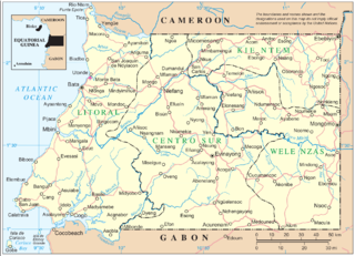
Río Muni is the Continental Region of Equatorial Guinea, and comprises the mainland geographical region, covering 26,017 square kilometres (10,045 sq mi). The name is derived from the Muni River, along which the early Europeans had built the Muni River Settlements.

Francisco Macías Nguema, often mononymously referred to as Macías, was an Equatoguinean politician who served as the first President of Equatorial Guinea from the country's independence in 1968 until his overthrow in 1979. He is widely remembered as one of the most brutal dictators in history.
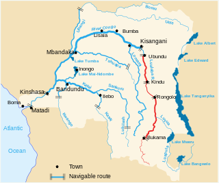
The Luama River is a tributary of the Lualaba River in the Democratic Republic of the Congo (DRC).
The Sanaga River is the largest river in Cameroon located in East Region, Centre Region and Littoral Region. Its length is about 603 km (375 mi) from the confluence of Djérem and Lom River. The total length of Sanaga-Djérem River system is about 1,067.5 km (663.3 mi). Djerem is the longest source of Sanaga River with a total length of 464.5 km.

The Benito is a river in Equatorial Guinea. It is known locally as the Mbini River, and, at least as it flows in its westerly part through the Monte Alen National Park, as the Uoro River. The river rises in Gabon and crosses into Equatorial Guinea where it divides the country roughly along the middle, running east to west. At the mouth to the Atlantic Ocean lies the town of Mbini, as well as large mangrove stands that extend 20 kilometres (12 mi) inland. Only this 20 kilometres (12 mi) portion of the river is navigable. The river is used to float logs for forestry operations. The cichlid genus Benitochromis takes the first part of its name from the Benito River.
Equatorial Guinea competed at the 1984 Summer Olympics in Los Angeles, United States, which were held from 28 July to 12 August. This was the first time the country took part in a Summer Olympics. The delegation consisted of four athletics competitors: sprinters Gustavo Envela and Secundino Borabota, and middle-distance runners Bartolomé Esono Asumu and Diosdado Lozano. All four failed to advance beyond the initial heats in their respective competitions. The best performance came from Envela who placed fifth in the eighth heat of the men's 100 metres.

The Muni is an estuary of several rivers of Equatorial Guinea and Gabon. Part of its length form part of the border with Gabon. It is from this estuary that the former name for this part of Equatorial Guinea, Río Muni was taken.
Sekayam River is a river of Borneo, West Kalimantan province, Indonesia. It is a tributary of the Kapuas River. The Public Forest System Utility Program has a scheme on the river aimed at reducing the level of mercury content absorbed by humans.
The Mitong is a river of southwestern mainland Equatorial Guinea. It forms part of the Muni Estuary along with the Congue River, Mandyani River, Mitimele River, Utamboni River and Mven River.
The Congue is a river of southwestern mainland Equatorial Guinea. It forms part of the Muni Estuary along with the Mitong River, Mandyani River, Mitimele River, Utamboni River and Mven River.
The Mandyani is a river of southwestern mainland Equatorial Guinea. It forms part of the Muni Estuary along with the Mitong River, Congue River, Mitimele River, Utamboni River and Mven River.
The Mven is a river of southwestern mainland Equatorial Guinea. It forms part of the Muni Estuary along with the Mitong River, Mandyani River, Mitimele River, Utamboni River and Congue River.
The Utamboni is a river of southwestern mainland Equatorial Guinea. It flows along the border with Gabon and forms part of the Muni Estuary along with the Mitimele River, Mitong River, Mandyani River, Congue River, and Mven River. The river becomes the Utamboni River along the border with Gabon.

Jumper's Bastion may refer to one of two adjacent bastions in the British Overseas Territory of Gibraltar. They were both created in 1785 on the sites of previous constructions and named for a British Captain who was one on the first on shore during the Capture of Gibraltar in 1704.
The Hodgkinson Mineral Area was a mining area near the Hodgkinson River about 80 km (50 mi) west of Cairns, in the present-day Shire of Mareeba in Queensland, Australia. It was the site of a gold rush in the 1870s.
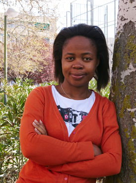
Trifonia Melibea Obono Ntutumu Obono is an Equatorial Guinean novelist, political scientist, academic and LGBT activist. Her novel La Bastarda is the first novel by a female Equatorial Guinean writer to be translated into English.
Cannabis in Equatorial Guinea is illegal with severe penalties for the production, sale, and possession of marijuana for medicinal or recreational purposes. Despite the illegality, smoking marijuana remains culturally popular among all strata of society, and it was reported in 2000 that no one has been arrested for smoking or dealing cannabis in living memory.
