Mitooma

Last updated

Mitooma
Uganda location map.svg
Red pog.svg
Mitooma
Location in Uganda
Coordinates: 00°36′54″S30°02′42″E / 0.61500°S 30.04500°E / -0.61500; 30.04500
Country Uganda
Region Western Region of Uganda
Sub-region Ankole sub-region
District Mitooma District
Elevation
5,069 ft (1,545 m)
Population
 (2020 Estimate)
  Total6,000 [1]

Mitooma, also Mitoma, is a town in the Western Region of Uganda. It is the main municipal, administrative, and commercial center of Mitooma District. [2]

Contents

Location

Mitooma Municipal Council is located in Ruhinda County, Mitooma District, Ankole sub-region, in Uganda's Western Region. This is approximately 23 kilometres (14 mi), by road, southwest of Bushenyi, the nearest large town. [3] Mitooma is located approximately 77 kilometres (48 mi), by road, west of Mbarara, the largest city in the Ankole sub-region. [4] The geographical coordinates of the town are 0°36'54.0"S, 30°02'42.0"E (Latitude:-0.6150; Longitude:30.0450). [5] Mitooma sits at an average elevation of 1,545 metres (5,069 ft) above mean sea level. [6]

Population

A cloudy sunset over tea leaves in Mitooma District in Western Uganda 02.jpg A cloudy sunset over tea leaves in Mitooma District in Western Uganda 02.jpg
A cloudy sunset over tea leaves in Mitooma District in Western Uganda 02.jpg

In 2015, Uganda Bureau of Statistics (UBOS) estimated the population of Mitooma Town Council at 5,700. In 2020, the population agency estimated the mid-year population of the town at 6,000 people. Of these, an estimated 3,100 (51.7 percent) were females and 2,900 (48.3 percent) were males. UBOS calculated that the town's population increased at an average rate of 1.03 percent annually, between 2015 and 2020. [1]

Points of interest

The following points of interest li within Mitooma Town Council, on near its borders. [5]

1. The offices of Mitooma Municipal Council

2. The headquarters of Mitooma District Administration

3. Mitooma Central Market

4. The western end of the tarmacked 12.5 kilometres (7.8 mi) Kashenyi–Mitooma Road, is located here.

5. The 31 kilometres (19 mi)Mitooma–Rukungiri Road, a heavily pot-holed dirt road starts here to end at Rukungiri, in Rukungiri District. [7]

See also

Related Research Articles

<span class="mw-page-title-main">Ntungamo District</span> District in Western Uganda, Uganda

Ntungamo District is a district in Western Uganda. Like most Ugandan districts, it named after its 'chief town', Ntungamo, the location of the district headquarters. Ntungamo was elevated to a district on 5th May 1993.

<span class="mw-page-title-main">Mbarara district</span> District in Western Uganda, Uganda

Mbarara District is a district in South Western Uganda. In 2019 Uganda cabinet approved part of Mbarara the then Mbarara municipality to be upgraded to a city status in July 2020.

<span class="mw-page-title-main">Bushenyi District</span> District in Western Uganda, Uganda

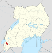
Bushenyi District is a district in Western Uganda. Like many other Ugandan districts, it is named after its chief town, Bushenyi, where the district headquarters are located.

<span class="mw-page-title-main">Kabale District</span> District in Western Region, Uganda

Kabale District is a district in the Western Region of Uganda. Kabale hosts the district headquarters. It was originally part of Kigezi District, before the districts of Rukungiri, Kanungu, Kisoro, Rubanda and Rukiga and were excised to form separate districts. Kabale is sometimes nicknamed "Kastone" as in the local language Rukiga, a "kabale" is a small stone.

<span class="mw-page-title-main">Bushenyi</span> Place in Western Uganda, Uganda

Bushenyi is a town in Western Uganda. It is the 'chief town' of Bushenyi District and the district headquarters are located there. The district is named after the town, in keeping with the practice in most of the districts in the country.

Rukungiri is a town in Rukungiri District of the Western Region of Uganda. It is the site of the district headquarters.

Ntungamo is a town in the Western Region of Uganda. It is the largest town in Ntungamo District and the site of the district headquarters.

Ibanda is a town in the Western Region of Uganda. It is the main political, administrative, and commercial centre of Ibanda District and the site of the district headquarters. It started wayback in 1990s and was elevated from a trading centre to a town board, town council and in 2016 it was granted a Municipality status. The Municipal Council has three Divisions of Kagongo, Bisheshe and Bufunda with 21 wards of Kyaruhanga, Bufunda, Nyamirima, Nsasi, Kayenje, Kashangura, Rwenshuri, Kigarama, Rugazi, Rwobuzizi, Kakatsi, Bugarama, Karangara, Kabaare, Kanyansheko, Nyakatookye, Kyeikucu, Kikoni, Kagongo, Ruyonza and Katongore ward. Ibanda Municipal Council has over 230 villages. Ibanda Municipal council commenced its operations on 1 July 2016 after being elevated from a Town Council and other sub counties that were annexed to..

Nakaseke is a town in Nakaseke District in the Central Region of Uganda. It is the main municipal and commercial center of the district. However, the political and administrative capital in the district is Butalangu.

Isingiro is a town in the Western Region of Uganda. It is the main municipal, administrative, and commercial center of Isingiro District and the site of the district's headquarters.

Kiruhura is a town in the Western Region of Uganda. It is the largest town in Kiruhura District and the site of the district headquarters.

Ankole sub-region is a region in the Western Region of Uganda that consists of the following districts:

<span class="mw-page-title-main">Rubirizi District</span> District in Western Uganda, Uganda

Rubirizi District is a district in Western Uganda. Like most Ugandan districts, the district is named after its 'chief town', Rubirizi, where the district headquarters are located.

<span class="mw-page-title-main">Buhweju District</span> District in Western Uganda, Uganda

Buhweju District is a district in Western Uganda. It is one of the districts that constitute the Ankole sub-region. Its 'chief town', is Nsiika.

<span class="mw-page-title-main">Mitooma District</span> District in Uganda

Mitooma District is a district in Western Uganda. It is named after its main municipal, administrative and commercial center, Mitooma.

<span class="mw-page-title-main">Sheema District</span> District in Western Uganda, Uganda

Sheema District is a district in Western Uganda.

Kibingo is a town in Western Uganda. It is the location of the district headquarters of Sheema District.

Kitagata is a town in Western Uganda. It is one of the urban centers in Sheema District.

Sanga, is an urban center in the Kiruhura District, Ankole sub-region, in the Western Region of Uganda.

Rugaaga is a town in Isingiro District in the Western Region of Uganda.

References

  1. 1 2 Uganda Bureau of Statistics (14 June 2020). "The population development of Mitooma as well as related information and services" (Citypopulaion.de Quoting Uganda Bureau of Statistics). Citypopulation.de. Retrieved 6 February 2021.
  2. Places In The World (6 February 2021). "Mitooma Town Council is a municipality in Ruhinda County in Mitooma District in Western Region in Uganda". Places In The World. Retrieved 6 February 2021.
  3. Google (6 February 2021). "Road Distance Between Bushenyi, Uganda And Mitooma, Uganda, With Map" (Map). Google Maps . Google. Retrieved 6 February 2021.
  4. Google (6 February 2021). "Road Distance Between Mbarara, Uganda And Mitooma, Uganda, With Map" (Map). Google Maps . Google. Retrieved 6 February 2021.
  5. 1 2 Google (6 February 2021). "Location of Mitooma, Uganda" (Map). Google Maps . Google. Retrieved 6 February 2021.
  6. Fallingrain (6 February 2021). "Elevation of Mitooma, Uganda". Fallingrain.com. Retrieved 6 February 2021.
  7. Google (6 February 2021). "Road Distance Between Mitooma, Uganda And Rukungiri, Uganda" (Map). Google Maps . Google. Retrieved 6 February 2021.