| Mitsikeli | |
|---|---|
| Μιτσικέλι | |
 Mitsikeli Location in Greece | |
| Highest point | |
| Elevation | 1,810 m (5,940 ft) [1] |
| Listing | List of mountains in Greece |
| Coordinates | 39°42′47″N20°54′22″E / 39.71306°N 20.90611°E Coordinates: 39°42′47″N20°54′22″E / 39.71306°N 20.90611°E |
| Naming | |
| Pronunciation | Greek: [mitsiˈceli] |
| Geography | |
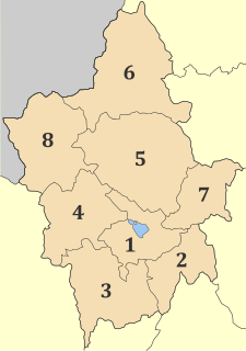
| Location | Ioannina regional unit, Greece |

Mitsikeli (Greek : Μιτσικέλι) is a mountain range in the central part of the Pindus mountains, in Epirus, Greece. The mountain is located northeast of Ioannina and Lake Ioannina. Its highest elevation is 1,810 m. [1] It stretches from near Kalpaki in the northwest to the eastern end of Lake Ioannina, a total length of 35 km. The northeastern slopes and the lower northwestern part of Mitsikeli are forested. The nearest mountains are the Tymfi to the north, the Lygkos to the northeast and the Lakmos to the east. It is drained by tributaries of the Thyamis to the northwest, towards Lake Ioannina to the southwest, by the Voidomatis (tributary of the Aoos) to the northeast and by the Arachthos to the southeast.

Greek is an independent branch of the Indo-European family of languages, native to Greece, Cyprus and other parts of the Eastern Mediterranean and the Black Sea. It has the longest documented history of any living Indo-European language, spanning more than 3000 years of written records. Its writing system has been the Greek alphabet for the major part of its history; other systems, such as Linear B and the Cypriot syllabary, were used previously. The alphabet arose from the Phoenician script and was in turn the basis of the Latin, Cyrillic, Armenian, Coptic, Gothic, and many other writing systems.

The Pindus mountain range is located in northern Greece and southern Albania. It is roughly 160 km long, with a maximum elevation of 2,637m. Because it runs along the border of Thessaly and Epirus, the Pindus range is known colloquially as the spine of Greece. The mountain range stretches from near the Greek-Albanian border in Northern Epirus, entering the Epirus and Macedonia regions in northern Greece down to the north of the Peloponnese. Geologically it is an extension of the Dinaric Alps, which dominate the western region of the Balkan Peninsula.

Epirus, is a traditional geographic and modern administrative region in northwestern Greece. It borders the regions of West Macedonia and Thessaly to the east, West Greece to the south, the Ionian Sea and Ionian Islands to the west and Albania to the north. The region has an area of about 9,200 km2 (3,600 sq mi). It is part of the wider historical region of Epirus, which overlaps modern Albania and Greece but lies mostly within Greek territory.
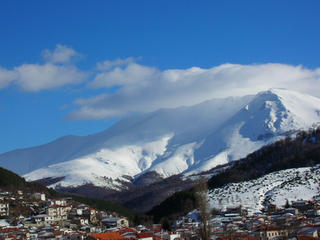
Mitsikeli forms the southwestern border of the Zagori region. Villages in the mountains include Kato Pedina and Asprangeloi in the northwest, Dikorfo and Perivleptos in the central part, and Kryovrysi in the southeast. The Greek National Road 6 (Larissa - Trikala - Ioannina - Igoumenitsa) passes south of the mountain, the Greek National Road 20 (Kozani - Konitsa - Ioannina) is to the west. The famous Perama Cave is to the southwest. There is a telecommunications tower on the summit.

Zagori, is a region and a municipality in the Pindus mountains in Epirus, in northwestern Greece. The seat of the municipality is the village Asprangeloi. It has an area of some 1,000 square kilometers and contains 46 villages known as Zagori villages, and is in the shape of an upturned equilateral triangle. Ioannina, the provincial capital, is at the southern point of the triangle, while the south-western side is formed by Mount Mitsikeli (1,810m). The Aoos river running north of Mt Tymphe forms the northern boundary, while the south-eastern side runs along the Varda river to Mount Mavrovouni (2,100m) near Metsovo. The municipality has an area of 989.796 km2. The population of the area is about 3,700, which gives a population density of 4 inhabitants per square kilometer, very sparse when compared to an average of 73.8 for Greece as a whole.

Kato Pedina is a village in the Ioannina regional unit in Epirus, Greece. It is in the municipality of Zagori. Its population was counted as 41 in the 2011 census. Kato Pedina is one of the Zagori villages, also known as Zagorochoria, and is in the municipal unit of Central Zagori. It is situated on a mountainside at 940 m elevation, in the northwestern foothills of the Mitsikeli mountains.
Dikorfo is a small village in the region of Epirus in Greece. The village belongs to the area of Zagori, which consists of 43 traditional villages in the Pindus mountains.