
Lichte is a village and a former municipality in the district of Sonneberg in Thuringia, Germany, close to the Thuringian Rennsteig. Formerly in the district Saalfeld-Rudolstadt, it is part of the town Neuhaus am Rennweg since January 2019.
Piesau is a village and a former municipality in the district of Sonneberg in Thuringia, Germany, close to the Thuringian Rennsteig. Formerly in the district Saalfeld-Rudolstadt, it is part of the town Neuhaus am Rennweg since January 2019.
Schmiedefeld is a village and a former municipality in the district Saalfeld-Rudolstadt, in Thuringia, Germany close to the Thuringian Rennsteig. Since 1 January 2019, it is part of the town Saalfeld. Before, it belonged to the municipal association Lichtetal am Rennsteig, which consisted of the municipalities Lichte, Piesau, Reichmannsdorf, and Schmiedefeld.
Lichtetal am Rennsteig is a former municipal association in the district of Saalfeld-Rudolstadt, in Thuringia, Germany. The seat of government was in Lichte. It was disbanded in January 2019.

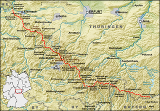
The Rennsteig is a ridge walk as well as an historical boundary path in the Thuringian Forest, Thuringian Highland and Franconian Forest in Central Germany. The long-distance trail runs for about 170 km from Eisenach and the Werra valley in the northwest to Blankenstein and the Selbitz river in the southeast.
Thuringian Forest Nature Park is one of two nature parks in the state of Thuringia, Germany.
The Mutzenberg is a 770.0 m high mountain located in the Thuringian Highland, Thuringia (Germany).
The Hahnberg is a 685.3 m high slightly undulatory tableland located in the Thuringian Highland, Thuringia (Germany).
The Spitzer Berg is a 790.3 m high mountain located in the Thuringian Highland, Thuringia (Germany).
The Apelsberg is a 785.3 m high mountain located in the Thuringian Highland, Thuringia (Germany).
The Rückersbiel a 755.6 m high mountain located in the Thuringian Highland, Thuringia (Germany).

The Rauhhügel is an 812.9 m high mountain located in the Thuringian Highland, Thuringia (Germany).
The Sauhügel is a 721.7 m high mountain located in the Thuringian Highland, Thuringia (Germany).

The Lichte (Thuringia) station German: Bahnhof Lichte (Thüringen) was a Deutsche Reichsbahn station in the Thuringian municipality of Lichte in the district of Saalfeld-Rudolstadt. The station is elevated 623 m above Sea Level.

The Lichte (Thuringia) east station was a Deutsche Reichsbahn station of the Thuringian municipality of Lichte (Wallendorf) in the district of Saalfeld-Rudolstadt.
The Piesau is a right tributary of the river Lichte in Thuringia, Germany. It is approximately 7 km (4.3 mi) long. The name is derived from the municipality of Piesau.
The Ascherbach is a left tributary of the Lichte in Thuringia, Germany, and is 4 km long.

The Kieselbach is a right tributary of the Lichte in Thuringia, Germany, and is 4 km (2.5 mi) long.
Ernstthal am Rennsteig is a municipality section of the so-called Glass-blower Town Lauscha in the district of Sonneberg in Thuringia, Germany, close to the Thuringian Rennsteig.
Wallendorf is an Ortsteil (subdivision) of the Lichte municipality. It is located in the district of Saalfeld-Rudolstadt in Thuringia, Germany, close to the Thuringian Rennsteig.
This page is based on this
Wikipedia article Text is available under the
CC BY-SA 4.0 license; additional terms may apply.
Images, videos and audio are available under their respective licenses.

