Mixcoac (archaeological site)

Last updated
Ruins of the Pyramid of Mixcoac Ruinas en Mixcoac.jpg
Ruins of the Pyramid of Mixcoac

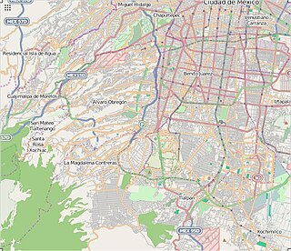
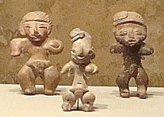
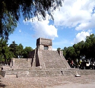
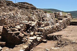
Mixcoac from Nahuatl means "viper in the cloud" is an archaeological zone belonging to the Mexica (Aztec) culture. It was on the shores of Lake Texcoco and in its final stage was under the rule of Tenochtitlan. With the arrival of the Spanish conquistadors, the settlement was practically destroyed to its foundations, which are the only thing that survives of the architecture of the place and can be appreciated today in what is today the San Pedro de los Pinos neighborhood, on the corner of San Antonio avenue and Periférico, in Mexico City.

Nahuatl, known historically as Aztec, is a language or group of languages of the Uto-Aztecan language family. Varieties of Nahuatl are spoken by about 1.7 million Nahua peoples, most of whom live in central Mexico.

Mexica indigenous people of the Valley of Mexico

The Mexica (Nahuatl: Mēxihcah, Nahuatl pronunciation: [meːˈʃiʔkaʔ] or Mexicas are a Nahuatl-speaking indigenous people of the Valley of Mexico who were the rulers of the Aztec Empire. This group was also known as the Culhua-Mexica in recognition of its kinship alliance with the neighboring Culhua, descendants of the revered Toltecs, who occupied the Toltec capital of Tula from the tenth through twelfth centuries. The Mexica were additionally referred to as the "Tenochca", a term associated with the name of their altepetl, Tenochtitlan, and Tenochtitlan's founding leader, Tenoch. The Mexica established Mexico Tenochtitlan, a settlement on an island in Lake Texcoco. A dissident group in Mexico-Tenochtitlan separated and founded the settlement of Mexico-Tlatelolco with its own dynastic lineage. The name Aztec was coined by Alexander von Humboldt who combined "Aztlan", their mythic homeland, and "tec ", 'people of'. The term Aztec is often used very broadly to refer not only to the Mexica, but also to the Nahuatl-speaking peoples or Nahuas of the Valley of Mexico and neighboring valleys.

Lake Texcoco former natural lake formation within the Valley of Mexico

Lake Texcoco was a natural lake within the "Anahuac" or Valley of Mexico. Lake Texcoco is best known as where the Aztecs built the city of Tenochtitlan, which was located on an island within the lake. After the Spanish conquest of the Aztec Empire, efforts to control flooding by the Spanish led to most of the lake being drained. The entire lake basin is now almost completely occupied by Mexico City, the capital of the present-day nation of Mexico.

Contents

The name Mixcoac, viper of the cloud, could be understood as a representation of the celestial serpent or Milky Way. The occupation of this archaeological area is estimated to have occurred from 900 BC to 1521 AD.

Snake limbless, scaly, elongate reptile

Snakes are elongated, legless, carnivorous reptiles of the suborder Serpentes. Like all other squamates, snakes are ectothermic, amniote vertebrates covered in overlapping scales. Many species of snakes have skulls with several more joints than their lizard ancestors, enabling them to swallow prey much larger than their heads with their highly mobile jaws. To accommodate their narrow bodies, snakes' paired organs appear one in front of the other instead of side by side, and most have only one functional lung. Some species retain a pelvic girdle with a pair of vestigial claws on either side of the cloaca. Lizards have evolved elongate bodies without limbs or with greatly reduced limbs about twenty-five times independently via convergent evolution, leading to many lineages of legless lizards. Legless lizards resemble snakes, but several common groups of legless lizards have eyelids and external ears, which snakes lack, although this rule is not universal.

Milky Way Spiral galaxy containing our Solar System

The Milky Way is the galaxy that contains our Solar System, with the name describing the galaxy's appearance from Earth: a hazy band of light seen in the night sky formed from stars that cannot be individually distinguished by the naked eye. The term Milky Way is a translation of the Latin via lactea, from the Greek γαλαξίας κύκλος. From Earth, the Milky Way appears as a band because its disk-shaped structure is viewed from within. Galileo Galilei first resolved the band of light into individual stars with his telescope in 1610. Until the early 1920s, most astronomers thought that the Milky Way contained all the stars in the Universe. Following the 1920 Great Debate between the astronomers Harlow Shapley and Heber Curtis, observations by Edwin Hubble showed that the Milky Way is just one of many galaxies.

History

The site was occupied and built by the Mexicas shortly before 1521. This is demonstrated by the aesthetics and style of pottery and the architecture of the buildings. The temple of Mixcoatl is a pyramid-shaped building to which another building was added, built with floors and cement walls and tepetate. The spaces between the two buildings, as was common at the time and following the example of Tenayuca, were filled with stones, mud and remains of the first building. On the site the foundations of a second building that had 15 rooms on top survive, most of them with floors. Several walls were also located on the south side. A number of adobe rooms were found in the northeast.

Tenayuca Archaeological site in Mexico

Tenayuca is a pre-Columbian Mesoamerican archaeological site in the Valley of Mexico. In the Postclassic period of Mesoamerican chronology, Tenayuca was a settlement on the former shoreline of the western arm of Lake Texcoco. It was located approximately 10 kilometres (6.2 mi) to the northwest of Tenochtitlan.

The site of Mixcoac, belonged to the altepetl of Coyohuacan when the lake area was the territory of the Tepanecs of Azcapotzalco, long before the arrival of the Mexicas to the Cemanahuac.

<i lang="nci" title="Classical Nahuatl language text">Altepetl</i> Mesoamerican political entity

The altepetl, in pre-Columbian and Spanish conquest-era Aztec society, was the local, ethnically-based political entity, usually translated into English as "city-state". The word is a combination of the Nahuatl words ātl and tepētl. A characteristic Nahua mode was to imagine the totality of the people of a region or of the world as a collection of altepetl units and to speak of them on those terms. The concept is comparable to Maya cah and Mixtec ñuu.

Coyoacán Alcaldía in Mexico City, Mexico

Coyoacán is a municipality (alcaldía) of Mexico City and the former village which is now the borough’s “historic center.” The name comes from Nahuatl and most likely means “place of coyotes,” when the Aztecs named a pre-Hispanic village on the southern shore of Lake Texcoco which was dominated by the Tepanec people. Against Aztec domination, these people welcomed Hernán Cortés and the Spanish, who used the area as a headquarters during the Spanish conquest of the Aztec Empire and made it the first capital of New Spain between 1521 and 1523. The village, later municipality, of Coyoacan remained completely independent of Mexico City through the colonial period into the 19th century. In 1857, the area was incorporated into the Federal District when this district was expanded. In 1928, the borough was created when the Federal District was divided into sixteen boroughs. The urban sprawl of Mexico City reached the borough in the mid 20th century, turning farms, former lakes and forests into developed areas, but many of the former villages have kept their original layouts, plazas and narrow streets and have conserved structures built from the 16th to the early 20th centuries. This has made the borough of Coyoacan, especially its historic center, a popular place to visit on weekends.

Tepanec

The Tepanecs or Tepaneca are a Mesoamerican people who arrived in the Valley of Mexico in the late 12th or early 13th centuries. The Tepanec were a sister culture of the Aztecs as well as the Acolhua and others—these tribes spoke the Nahuatl language and shared the same general pantheon, with local and tribal variations.

Mixcoac had a privileged location, as it was located near the great lake, as well as the rivers and streams that descended from the mountainous area located to the west (the current neighborhood of Santa Fe). Numerous agricultural towns were built around it. It is thought that the place was frequented by musicians and dancers from the Valley of Mexico and that a very popular party was held between receiving the views of the inhabitants of Tenochtitlan, Tlatelolco and other nearby towns. As part of these festivities, hunting excursions were carried out from this site to the surroundings of the mount of Zacatepec, before the beginning of the hunt the participants had to go through the adoration of Mixcoatl.

Santa Fe, Mexico City District of Mexico City

Santa Fe is one of Mexico City's major business districts, located in the west part of the city in the alcaldías (boroughs) of Cuajimalpa and Álvaro Obregón. The Paseo de la Reforma avenue and Constituyentes avenue are the primary means of access to the district from the central part of Mexico City. Santa Fe consists mainly of highrise buildings surrounding a large shopping mall, Centro Santa Fe, which is currently the largest mall in Latin America. The district also includes a residential area and three university campuses, among other facilities.The Toluca–Mexico City commuter rail, due to open in 2020, will also improve mobility and development in the district.

Valley of Mexico highlands plateau in central Mexico

The Valley of Mexico is a highlands plateau in central Mexico roughly coterminous with present-day Mexico City and the eastern half of the State of Mexico. Surrounded by mountains and volcanoes, the Valley of Mexico was a centre for several pre-Columbian civilizations, including Teotihuacan, the Toltec, and the Aztec. The ancient Aztec term Anahuac and the phrase Basin of Mexico are both used at times to refer to the Valley of Mexico. The Basin of Mexico became a well known site that epitomized the scene of early Classic Mesoamerican cultural development as well.

Tenochtitlan Former city-state in the Valley of Mexico

Tenochtitlan, also known as Mexica-Tenochtitlan, was a large Mexica city-state in what is now the center of Mexico City. The exact date of the founding of the city is unclear. The date March 13, 1325, was chosen in 1925 to celebrate the 600th anniversary of the city. The city was built on an island in what was then Lake Texcoco in the Valley of Mexico. The city was the capital of the expanding Aztec Empire in the 15th century until it was captured by the Spanish in 1521.

The samples of ceramics from the area are stylistically related to the other sites of contemporary culture of Mesoamerica as Zacatenco, El Arbolillo and Ticomán. There are also magnificent examples of vases and boxes with clear Teotihuacan influence.

El Arbolillo is a Mesoamerican archaeological site located in the territory of the current municipality of Tlalnepantla de Baz, in the State of Mexico. It contains the remains of an ancient farming village that developed during the preclassical mesoamerican period, in the west shores of the Texcoco Lake. According to available data, the earliest occupation of this site could be dated to 900 BCE.

Ticomán Central Plateau Mesoamerican peoples

Ticomán is an archaeological site located in the Gustavo A. Madero municipality in Mexico City. It corresponds to an ancient town of the Pre-Classical Mesoamerican period, whose inhabitants could have been Otomis. It was a contemporary population of Tlatilco, Cuicuilco, El Arbolillo and Zacatenco.

Teotihuacan Pre-Columbian Mesoamerican city located in a sub valley of the Valley of Mexico

Teotihuacan is an ancient Mesoamerican city located in a sub-valley of the Valley of Mexico, which is located in the State of Mexico, 40 kilometres (25 mi) northeast of modern-day Mexico City. Teotihuacan is known today as the site of many of the most architecturally significant Mesoamerican pyramids built in the pre-Columbian Americas. At its zenith, perhaps in the first half of the first millennium CE, Teotihuacan was the largest city in the pre-Columbian Americas, with a population estimated at 125,000 or more, making it at least the sixth-largest city in the world during its epoch. After the collapse of Teotihuacan, central Mexico was dominated by the Toltecs of Tula until about 1150 CE.

The site was not open to the public, however, in August 2019, the INAH reported that the area can already be visited, access is free. [1]

See also

Related Research Articles

Aztecs Ethnic group of central Mexico and its civilization

The Aztecs were a Mesoamerican culture that flourished in central Mexico in the post-classic period from 1300 to 1521. The Aztec peoples included different ethnic groups of central Mexico, particularly those groups who spoke the Nahuatl language and who dominated large parts of Mesoamerica from the 14th to the 16th centuries. Aztec culture was organized into city-states (altepetl), some of which joined to form alliances, political confederations, or empires. The Aztec Empire was a confederation of three city-states established in 1427: Tenochtitlan, city-state of the Mexica or Tenochca; Texcoco; and Tlacopan, previously part of the Tepanec empire, whose dominant power was Azcapotzalco. Although the term Aztecs is often narrowly restricted to the Mexica of Tenochtitlan, it is also broadly used to refer to Nahua polities or peoples of central Mexico in the prehispanic era, as well as the Spanish colonial era (1521–1821). The definitions of Aztec and Aztecs have long been the topic of scholarly discussion ever since German scientist Alexander von Humboldt established its common usage in the early nineteenth century.

Benito Juárez, Mexico City Delegación in Mexico City, Mexico

Benito Juárez, is one of the 16 alcaldías (boroughs), formerly delegaciones, into which Mexico City is divided. It is a largely residential area, located to the south of historic center of Mexico City, although there are pressures for areas to convert to commercial use. It was named after Benito Juárez, president in the 19th century. The borough has the highest socioeconomic index in the country as it is primarily populated by the middle and upper middle classes. The borough is home to a number of landmarks such as the World Trade Center Mexico City, the Estadio Azul, the Plaza México and the Polyforum Cultural Siqueiros.

<i>Templo Mayor</i> national museum

The Templo Mayor was the main temple of the Mexica peoples in their capital city of Tenochtitlan, which is now Mexico City. Its architectural style belongs to the late Postclassic period of Mesoamerica. The temple was called the Huēyi Teōcalli[we:ˈi teoːˈkali] in the Nahuatl language. It was dedicated simultaneously to Huitzilopochtli, god of war, and Tlaloc, god of rain and agriculture, each of which had a shrine at the top of the pyramid with separate staircases. The spire in the center of the adjacent image was devoted to Quetzalcoatl in his form as the wind god, Ehecatl. The Great Temple devoted to Huitzilopochtli and Tlaloc, measuring approximately 100 by 80 m at its base, dominated the Sacred Precinct. Construction of the first temple began sometime after 1325, and it was rebuilt six times. The temple was destroyed by the Spanish in 1521 to make way for the new cathedral.

Aztec Empire Imperial alliance of city states located in central Mexico during the 15th and 16th centuries

The Aztec Empire, or the Triple Alliance, was an alliance of three Nahua altepetl city/states: Mexico-Tenochtitlan, Texcoco, and Tlacopan. These three city-states ruled the area in and around the Valley of Mexico from 1428 until the combined forces of the Spanish conquistadores and their native allies under Hernán Cortés slaughtered them in 1521.

Cerro de la Estrella (archaeological site)

Cerro de la Estrella is a mesoamerican archaeological site located in southeastern Central Mexico's Valley of Mexico, in the Iztapalapa alcaldía of Mexico City at an elevation of 2460 meters (8070 ft) above sea level, hence its Summit is 224 m over the Valley of Mexico level. At the southeast edge of what was the Great Texcoco Lake.

History of the Aztecs aspect of history

The Aztecs were a Pre-Columbian Mesoamerican people of central Mexico in the 14th, 15th, and 16th centuries. They called themselves Mexica.

Calixtlahuaca human settlement in Mexico

Calixtlahuaca is a Postclassic period Mesoamerican archaeological site, located near the present-day city of Toluca in the State of Mexico. Known originally as "Matlatzinco", this urban settlement was a powerful capital whose kings controlled a large territory in the Toluca Valley.

Xaltocan sistema de lagos en Mejico precolombino

Xaltocan was a pre-Columbian city-state and island in the Valley of Mexico, located in the center of Lake Xaltocan, part of an interconnected shallow lake system which included Lake Texcoco, this place is inside the San Miguel Jaltocan, in Nextlapan. The site was originally settled by the Otomi people, but following a war in the late fourteenth century where the Otomi were defeated by an alliance of Tepanecs and Mexica the Otomi were driven off the island and relocated to Otumba, Metztitlan and Tlaxcala. The island of Xaltocan was then resettled by Nahuatl speakers. The name can mean either of two things in the Nahuatl language: either 'sandy ground of spiders' or 'where sand sowing'.

Tlatelolco (altepetl) pre-Columban city (altepetl) in Mexico

Tlatelolco was a prehispanic altepetl or city-state, in the Valley of Mexico. Its inhabitants were known as Tlatelolca. The Tlatelolca were a part of the Mexica, a Nahuatl-speaking people who arrived in what is now central Mexico in the 13th century. The Mexica settled on an island in Lake Texcoco, founding the altepetl of Mexico-Tenochtitlan on the southern portion of the island. In 1337, a group of dissident Mexica broke away from the Tenochca leadership in Tenochtitlan and founded Mexico-Tlatelolco on the northern portion of the island. Tenochtitlan was closely tied with its sister city, which was largely dependent on the market of Tlatelolco, the most important site of commerce in the area.

Santa Cecilia Acatitlan

Acatitlan is an archeological zone of the early Aztec culture located in the town of Santa Cecilia, in the municipality of Tlalnepantla de Baz in Mexico State, about 10 km northwest of Mexico City. In pre-Hispanic times it was located on the northwest shore of the great Lake Texcoco.

Chimalhuacán is an archeological site located in the city and municipality of Chimalhuacán Atenco in the eastern part of Mexico State, Mexico. It lies just outside the northeast border of the Federal District. The name derives from the Nahuatl words “chimalli” (shield), hua and can (place), this would mean "Place of Shields".The ancient name of the city by its founders was “Chimalhuacantoyac”.The word Atenco, is also Nahuatl; A, “water”; tentli, “lip” and co, “place”, hence would mean “at the water side”.

Ixcateopan (archaeological site)

Ixcateopan is an archaeological site located in the town and municipality of Ixcateopan de Cuauhtémoc, 36 kilometers from Taxco, in the isolated and rugged mountains of the northern part of Guerrero state, Mexico.

Xochimilco was the most important city of the Xochimilca people, one of the Nahua tribes that migrated to the Mesoamerica region. At the same time it was the name of the altepetl of this group and historically referred to both interchangebly. The city was founded around 900 AD. It grew to become an important city in the Valley of Mexico, until in 1430, the Mexica of Tenochtitlan succeeded in conquering the city.

Pueblo Culhuacán Neighborhood of Mexico City in Iztapalapa

Pueblo Culhuacán is an officially designated neighborhood of the Iztapalapa borough of Mexico City, which used to be a major pre Hispanic city. Ancient Culhuacán was founded around 600 CE and the site has been continuously occupied since. The city was conquered by the Aztecs in the 15th century, but the Aztecs considered the city to have status with early rulers marrying into Culhua nobility to legitimize themselves. After the Spanish conquest of the Aztec Empire, the Franciscans and later the Augustinians made Culhuacán a major evangelization center, with the latter building the monastery complex which remains to this day. Today, Culhucan is fully integrated into Mexico City physically and politically. This area was designated as a "Barrio Mágico" by the city in 2011.

Mixcoac Neighborhood in Mexico City

Mixcoac is an area of southern Mexico City which used to be a separate town and municipality within the Mexican Federal District until it was made part of Mexico City proper in 1928.

Third letter of Hernán Cortés to the Emperor Charles V letter in which Hernán Cortés reports his travels to Mexico to emperor Carlos I of Spain

The Third Letter of Relation of Hernán Cortés to the Emperor Carlos V is one of five letters written by the Spanish conquistador Hernán Cortés to the emperor Carlos V, sent with the intention of informing Carlos V of the territories discovered and their conquest; it was signed on 15 May 1522 in Coyoacán. The letter describes part of the expedition to the New World, the conquest of Tenochtitlán and the destruction of the city, covering the events from 1520 until the final conquests in 1522.

San Pedro de los Pinos Neighborhood of Mexico City in Benito Juárez

San Pedro de los Pinos is a neighborhood located in center-west of Mexico City. Before being urbanized during the first half of the 20th century, the colonia was part of a vast farming area belonging to several ranches and haciendas.

References

  1. Yanireth Israde (24 August 2019). "Abren zona arqueológica de Mixcoac". Reforma (in Spanish). Mexico City.

Coordinates: 19°23′11″N99°11′24″W / 19.3863°N 99.1899°W / 19.3863; -99.1899