Miyako Bay

Last updated
Miyako Bay

Gulf Miyako 01.jpg

Miyako Bay
Japan natural location map with side map of the Ryukyu Islands.jpg
Red pog.svg
Miyako Bay
Location Iwate Prefecture, Japan
Coordinates 39°36′N141°58′E / 39.600°N 141.967°E / 39.600; 141.967
Ocean/sea sources Pacific Ocean
Basin  countries Japan
Max. length 10 km (6.21 mi)
Max. width 4.8 km (2.98 mi)
Surface area 24 km2 (9.3 sq mi)
Average depth 76 m (249 ft)
Settlements Miyako, Mutsu

Miyako Bay(宮古湾,Miyako-wan) is a bay in Iwate Prefecture, in the northern Tōhoku region of northern Japan. It is a long and narrow, roughly triangular body of water extending southwest to northeast where it opens to the Pacific Ocean. The Omoe Peninsula(重茂半島,Omoe-hantō) forms its southern border and Cape Anegasaki(姉ヶ崎,Anegasaki) forms its southern border. This gives it an area of approximately 24 km2 (9.3 sq mi). [1]

Iwate Prefecture Prefecture of Japan

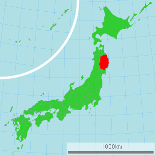
Iwate Prefecture is a prefecture in the Tōhoku region of Japan. Located on the main island of Honshu, it contains the island's easternmost point. The capital is Morioka. Iwate has the lowest population density of any prefecture outside Hokkaido. Famous attractions include the Buddhist temples of Hiraizumi, including Chūson-ji and Mōtsū-ji with their treasures, Fujiwara no Sato, a movie lot and theme park in Esashi Ward, Oshu City, Tenshochi, a park in Kitakami City known for its big, old cherry trees and Morioka Castle in Morioka City.

Tōhoku region Region

The Tōhoku region, Northeast region, or Northeast Japan consists of the northeastern portion of Honshu, the largest island of Japan. This traditional region consists of six prefectures (ken): Akita, Aomori, Fukushima, Iwate, Miyagi, and Yamagata.

Japan Constitutional monarchy in East Asia

Japan is an island country in East Asia. Located in the Pacific Ocean, it lies off the eastern coast of the Asian continent and stretches from the Sea of Okhotsk in the north to the East China Sea and the Philippine Sea in the south.

Miyako Bay is approximately 10 km (6.21 mi) long, with a width of 4.8 km (2.98 mi) at its mouth. The bay has an average depth of 20-40 meters, with a maximum depth of 76 m (249 ft). [1]

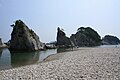
Economically, the shallow waters of the bay are an important fishery, with shellfish and seaweed cultivation and aquaculture benefiting from nutrients brought into the almost enclosed waters of the bay the Hei River and the effects of the offshore Kuroshio and Oyashio currents. Tourism is also economically important, as parts of the bay are within the borders of the Sanriku Fukkō National Park, including the scenic Jōdogahama coastline.

Aquaculture Farming of aquatic organisms

Aquaculture, also known as aquafarming, is the farming of fish, crustaceans, molluscs, aquatic plants, algae, and other organisms. Aquaculture involves cultivating freshwater and saltwater populations under controlled conditions, and can be contrasted with commercial fishing, which is the harvesting of wild fish. Mariculture refers to aquaculture practiced in marine environments and in underwater habitats.

Oyashio Current A cold subarctic ocean current that flows south and circulates counterclockwise in the western North Pacific Ocean

Oyashio, also known as Oya Siwo, Okhotsk or the Kurile current, is a cold subarctic ocean current that flows south and circulates counterclockwise in the western North Pacific Ocean. The waters of the Oyashio Current originate in the Arctic Ocean and flow southward via the Bering Sea, passing through the Bering Strait and transporting cold water from the Arctic Sea into the Pacific Ocean and the Sea of Okhotsk. It collides with the Kuroshio Current off the eastern shore of Japan to form the North Pacific Current. The nutrient-rich Oyashio is named for its metaphorical role as the parent that provides for and nurtures marine organisms.

Sanriku Fukkō National Park

Sanriku Fukkō National Park is a national park extending along the Sanriku Coast of Japan from Hachinohe in Aomori Prefecture through Iwate Prefecture to Kesennuma in Miyagi Prefecture. Created in 2013 in the aftermath of the 2011 Tōhoku earthquake and tsunami, it incorporates the former Rikuchū Kaigan National Park and Tanesashi Kaigan Hashikamidake Prefectural Natural Park. In 2014, the Ministry of the Environment plans to extend the park to include Minami Sanriku Kinkasan Quasi-National Park. Subsequently, the park will be extended to include Kesennuma Prefectural Natural Park, Kenjōsan Mangokuura Prefectural Natural Park, and Matsushima Prefectural Natural Park. At northern part of the national park there is an 8 km long and 200m-high set of cliffs called the Kita Yamazaki; it is said to be Japan's most beautiful coastline.

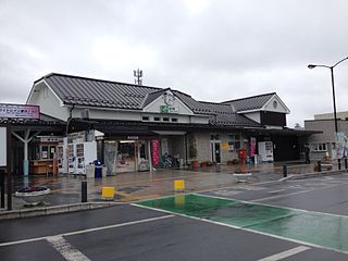
The Port of Miyako serves as the main seaport for the city of Morioka.

Related Research Articles

Geography of Albania

Albania is a small country in Southern and Southeastern Europe strategically positioned on the Adriatic and Ionian Sea inside the Mediterranean Sea, with a coastline of about 476 km (296 mi). It is bounded by Montenegro to the northwest, Kosovo to the northeast, North Macedonia to the east and Greece to the southeast and south.

Geography of North Korea

North Korea is located in East Asia on the Northern half of the Korean Peninsula.

Miyako, Iwate City in Tōhoku, Japan

Miyako is a city located in Iwate Prefecture, Japan. As of 1 April 2017, the city had an estimated population of 54,573, and a population density of 43.3 persons per km2. The total area of the city is 1,259.15 square kilometres (486.16 sq mi).

Sakishima Islands island group

The Sakishima Islands are an archipelago located at the southernmost end of the Japanese Archipelago. They are part of the Ryukyu Islands and include the Miyako Islands and the Yaeyama Islands. The islands are administered as part of Okinawa Prefecture, Japan.

Miyako District, Okinawa district of Okinawa Prefecture

Miyako is a district located in Okinawa Prefecture, Japan, that consists of a single village, Tarama.

Jiaozhou Bay sea

The Jiaozhou Bay is a gulf located in Qingdao, China. It was a German colonial concession from 1898 until 1914.

San Pablo Bay bay in San Francisco Bay area

San Pablo Bay is a tidal estuary that forms the northern extension of San Francisco Bay in the East Bay and North Bay regions of the San Francisco Bay Area in northern California.

Tarō, Iwate Former municipality in Tōhoku, Japan

Tarō was a town located in Shimohei District, Iwate Prefecture in Japan, and forms part of the city of Miyako

Shimohei District, Iwate district of Japan

Shimohei is a rural district in Iwate Prefecture, in the Tōhoku region of northern Japan. As of 2017, the district has an estimated population of 30,983 and a population density of 20.9 persons per km². The total area is 1,481.02 km².

Miyako-jima island in Okinawa, Japan

Miyako Island is the largest and the most populous island among the Miyako Islands of Okinawa Prefecture, Japan. Miyako Island is administered as part of the City of Miyakojima, which includes not only Miyako Island, but also five other populated islands.

Kluane Lake lake in Canada

Kluane Lake is located in the southwest area of the Yukon. It is the largest lake contained entirely within Yukon at approximately 408 km2 (158 sq mi), and 81 km (50 mi) long.

Miyako Station railway station in Miyako, Iwate prefecture, Japan

Miyako Station is a railway station in the city of Miyako, Iwate, Japan, operated by the Sanriku Railway.

Miyakojima, Okinawa City in Kyushu, Japan

Miyakojima is a city jurisdiction located on several islands in Okinawa Prefecture, Japan.

Battle of Miyako Bay naval action on 6 May 1869, part of the overall Battle of Hakodate at the end of the Boshin War

The Battle of Miyako Bay was a naval action on 6 May 1869. It was part of the overall Battle of Hakodate at the end of the Boshin War, a civil war in Japan between Imperial forces of the new Meiji government, and samurai loyalists to the former Tokugawa shogunate.

Mutsu Bay bay

Mutsu Bay is a bay in Aomori Prefecture, in the northern Tōhoku region of northern Japan. It is bordered by the Tsugaru Peninsula to the west, the Shimokita Peninsula to the east and north, with an east-west distance of approximately 40 kilometres (25 mi) and a north-south distance of approximately 40 kilometres (25 mi) at its eastern end, with a total area of approximately 1,667.89 square kilometres (643.98 sq mi). The outlet of the bay is the 14 kilometres (8.7 mi) wide Tairadate Strait which connects Mutsu Bay to the Tsugaru Strait separating the islands of Honshu and Hokkaido. The bay has an average depth of 40 metres (130 ft) to 45 metres (148 ft), with a maximum depth of 70 metres (230 ft) near its outlet to the Tsugaru Strait.

Mudan incident killing of 54 Ryūkyūan sailors in Qing-era Taiwan who wandered into Taiwan after shipwreck, causing the Taiwan Expedition of 1874 by Japan

The Mudan incident of 1871 was the massacre of 54 Ryūkyūan sailors in Qing-era Taiwan who wandered into the central part of Taiwan after their ship was shipwrecked. 12 men were rescued by Han Chinese and were transferred to Miyako Island in the Ryukyus. Japan sent a military force to Taiwan in the Taiwan Expedition of 1874 killing 16 aborigines while the aborigines killed 6 of their own soldiers in retaliation for the murdered Ryukyuan sailors, in retaliation for what Japan viewed as the murder of their citizens by rebellious aboriginal peoples out of the control but in the dominion of the failing Qing dynasty.

Ōmura Bay Bay in Nagasaki, Japan

Ōmura Bay is a bay of the East China Sea in the centre of Nagasaki Prefecture, Japan.

Jōdogahama Part of the Rikuchū Kaigan National Park, in Miyako, Iwate Prefecture, Japan.

Jōdogahama (浄土ヶ浜) is a series of rock formations along the coast of Miyako Bay in the city of Miyako, Iwate Prefecture, in the Tōhoku region of northern Japan. The area is part of the Sanriku Fukkō National Park, and is also a nationally designated Place of Scenic Beauty.

Miho Bay

Miho Bay is a bay on the north coast of western Honshu, the largest island of Japan. The bay faces the Sea of Japan and within the borders of Tottori Prefecture. Miho bay is bounded to the west by Yumigahama Peninsula, which forms the western border with Shimane Prefecture.

Miyako Strait strait

The Miyako Strait, also known as the Kerama Gap, is a waterway which lies between Miyako Island and Okinawa Island consisting of an approx. 250km wide passageway with international waters and airspace. It is the widest strait in the Ryukyu Islands.

References

  1. 1 2 【閉鎖性海域ネット】 宮古湾 (in Japanese). Ministry of the Environment of Japan. April 1, 2004.