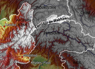
The Wakhan Corridor is a narrow strip of territory in Badakhshan Province of Afghanistan, extending to Xinjiang in China and separating the Gorno-Badakhshan Autonomous Region of Tajikistan in the north from the northern areas of Pakistan in the south. From this high mountain valley the Panj and Pamir rivers emerge and form the bigger Amu River. A trade route through the valley has been used by travellers going to and from East, South and Central Asia since antiquity.

Badakhshan Province is one of the 34 provinces of Afghanistan, located in the northeastern part of the country. It is bordered by Tajikistan's Gorno-Badakhshan in the north and the Pakistani regions of Lower and Upper Chitral and Gilgit-Baltistan in the southeast. It also has a 91-kilometer (57-mile) border with China in the east.
Fayzabad Airport is located about 3.5 miles (5.6 km) northwest of Fayzabad, the capital of Badakhshan Province in Afghanistan. It is a domestic airport under the country's Ministry of Transport and Civil Aviation (MoTCA), and serves the population of Badakhshan Province. Security in and around the airport is provided by the Afghan National Security Forces.
Amurn is a village in Darwaz District, Badakhshan Province in north-eastern Afghanistan.

Arakht is a village in Badakhshan Province in north-eastern Afghanistan.
Ashnam is a village in Badakhshan Province in north-eastern Afghanistan.
Fotur is a village on the left bank of the Ab-i-Panj river in Badakhshan Province in north-eastern Afghanistan.
Khash Darreh is the name of two villages in Badakhshan Province in north-eastern Afghanistan.
Kushgag is a village in Badakhshan Province in north-eastern Afghanistan.
Langar is a village in the Wakhan District of Badakhshan Province, in north-eastern Afghanistan. It lies on the river Panj, opposite the larger village of Toqakhona in Tajikistan.
Mina Do is a village in Badakhshan Province in northeast Afghanistan.
Mina Vad is a village in Badakhshan Province in north-eastern Afghanistan.
Mirkan is a town in Badakhshan Province in north-eastern Afghanistan.
Qalʽeh-ye Bar Panj is a village in Badakhshan Province in north-eastern Afghanistan.
Qalʽeh-ye Kuf or Qala-e Kuf Persian: قلعه کوف is a village and Capital District Kuf Ab in Badakhshan Province in north-eastern Afghanistan.
Qazi Deh is a village in Badakhshan Province in north-eastern Afghanistan. It lies on the left bank of the Panj River, 20 km from Ishkashim.
Ntete is a village in Ancuabe District in Cabo Delgado Province in northeastern Mozambique.
Muigima is a village in Ancuabe District in Cabo Delgado Province in northeastern Mozambique.

The Wakhjir Pass, also spelled Vakhjir Pass, is a mountain pass in the Hindu Kush or Pamirs at the eastern end of the Wakhan Corridor, the only potentially navigable pass between Afghanistan and China in the modern era. It links Wakhan in Afghanistan with the Tashkurgan Tajik Autonomous County in Xinjiang, China, at an altitude of 4,923 metres (16,152 ft), but the pass is not an official border crossing point. With a difference of 3.5 hours, the Afghanistan–China border has the sharpest official change of clocks of any international frontier. China refers to the pass as South Wakhjir Pass, as there is a northern pass on the Chinese side.
Events in the year 2023 in Afghanistan.
