
Skryplewo is a village in the administrative district of Gmina Hajnówka, within Hajnówka County, Podlaskie Voivodeship, in north-eastern Poland, close to the border with Belarus. It lies approximately 7 kilometres (4 mi) north-east of Hajnówka and 48 km (30 mi) south-east of the regional capital Białystok.
Połymie is a village in the administrative district of Gmina Narewka, within Hajnówka County, Podlaskie Voivodeship, in north-eastern Poland, close to the border with Belarus. It lies approximately 7 kilometres (4 mi) north of Narewka, 24 km (15 mi) north-east of Hajnówka, and 48 km (30 mi) south-east of the regional capital Białystok.

The Borzeşti Power Station is a large thermal power plant located in Borzeşti, having 7 generation groups, 3 of 25 MW, 2 of 50 MW, 1 of 60 MW and 1 of 210 MW having a total electricity generation capacity of 655 MW.
Psary Stare is a village in the administrative district of Gmina Wolbórz, within Piotrków County, Łódź Voivodeship, in central Poland.
Barycz is a village in the administrative district of Gmina Żytno, within Radomsko County, Łódź Voivodeship, in central Poland. It lies approximately 11 kilometres (7 mi) east of Żytno, 28 km (17 mi) south-east of Radomsko, and 98 km (61 mi) south of the regional capital Łódź.
Zielona Ulica is a village in the administrative district of Gmina Biecz, within Gorlice County, Lesser Poland Voivodeship, in southern Poland. It lies approximately 6 kilometres (4 mi) north-west of Biecz, 14 km (9 mi) north of Gorlice, and 97 km (60 mi) east of the regional capital Kraków.

Sąspów is a village in the administrative district of Gmina Jerzmanowice-Przeginia, within Kraków County, Lesser Poland Voivodeship, in southern Poland. It lies approximately 2 kilometres (1 mi) north-east of Jerzmanowice and 23 km (14 mi) north-west of the regional capital Kraków.
Borzykowa is a village in the administrative district of Gmina Chmielnik, within Kielce County, Świętokrzyskie Voivodeship, in south-central Poland. It lies approximately 7 kilometres (4 mi) south of Chmielnik and 39 km (24 mi) south of the regional capital Kielce.
Wałkonowy Dolne is a village in the administrative district of Gmina Secemin, within Włoszczowa County, Świętokrzyskie Voivodeship, in south-central Poland. It lies approximately 4 kilometres (2 mi) east of Secemin, 11 km (7 mi) south-west of Włoszczowa, and 53 km (33 mi) west of the regional capital Kielce.
Skłody-Piotrowice is a village in the administrative district of Gmina Zaręby Kościelne, within Ostrów Mazowiecka County, Masovian Voivodeship, in east-central Poland.
Kamień is a settlement in the administrative district of Gmina Pyzdry, within Września County, Greater Poland Voivodeship, in west-central Poland.
Bonowice is a village in the administrative district of Gmina Szczekociny, within Zawiercie County, Silesian Voivodeship, in southern Poland. It lies approximately 4 kilometres (2 mi) west of Szczekociny, 30 km (19 mi) north-east of Zawiercie, and 70 km (43 mi) north-east of the regional capital Katowice.
Bukowina is a village in the administrative district of Gmina Trzebiel, within Żary County, Lubusz Voivodeship, in western Poland, close to the German border. It lies approximately 4 kilometres (2 mi) west of Trzebiel, 26 km (16 mi) west of Żary, and 62 km (39 mi) south-west of Zielona Góra.
Kopaniec is a settlement in the administrative district of Gmina Polanów, within Koszalin County, West Pomeranian Voivodeship, in north-western Poland.
Wągrodno is a settlement in the administrative district of Gmina Szczecinek, within Szczecinek County, West Pomeranian Voivodeship, in north-western Poland. It lies approximately 8 kilometres (5 mi) south-east of Szczecinek and 149 km (93 mi) east of the regional capital Szczecin.
Sedlec is a village and municipality in Mladá Boleslav District in the Central Bohemian Region of the Czech Republic.

Holijaci is a village in the municipality of Višegrad, Bosnia and Herzegovina.
Bešište is a village in Municipality of Prilep, North Macedonia.
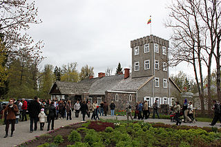
Burbiškis Manor is a former residential manor in Radviliškis district. It is famous for its tulips festival.

Mikhail Kutuzov was a light cruiser project no. 68-bis of the Soviet and later the Russian Navy's Black Sea Fleet.


