Modes of transport in Fiji include rail, road, water, and air. The rail network is mainly used for movement of sugar cane. Suva and Lautoka are the largest seaports. There are 122 km of navigable inland waterways. There are two international airports, one other paved airport, and over 20 with unpaved runways. With 333 tropical islands that make up this country, one can expect to use various modes of transport to get to their destination.

Air Fiji was an airline based in Nausori, Fiji. It operated inter-island services to destinations within the Fijian Islands. Its main base was Nausori International Airport, Suva, with a base at Nadi International Airport.

The Eastern Division of Fiji is one of Fiji's four divisions. It consists of Kadavu Province, Lau Province, Lomaiviti Province and Rotuma.
The Lau Islands of Fiji are situated in the southern Pacific Ocean, just east of the Koro Sea. Of this chain of about sixty islands and islets, about thirty are inhabited. The Lau Group covers a land area of 188 square miles, and had a population of 10,683 at the most recent census in 2007. While most of the northern Lau Group are high islands of volcanic origin, those of the south are mostly carbonate low islands.
Matuku is a volcanic island in the Moala subgroup of Fiji's Lau archipelago. Located at 19.18° South and 179.75° East, Matuku covers an area of 57 square kilometers. It has a maximum elevation of 385 meters. Matuku is part of a group of islands known as Yasayasa Moala.

Moala is a volcanic island in the Moala subgroup of Fiji's Lau archipelago. It has an area of 62.5 square kilometers (24.1 sq mi), making it the ninth largest island of Fiji. The highest point on the island of Moala, at a maximum elevation of 468 meters (1,535 ft), is called Delaimoala which has rich vegetation and consists of dark thick forest. The population of around 3000 live in eight villages. The chief village of Naroi, whose population is over 500, was formalised during the colonial era to entertain those that would not be entertained elsewhere. Economic activities include coconut farming, cocoa production, fishing and yaqona (kava) production.
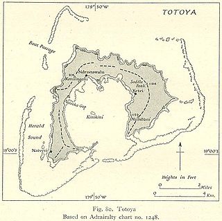
Totoya is a volcanic island in the Moala subgroup of Fiji's Lau archipelago. It occupies an area of 28 km2, making it the smallest of the Yasayasa Moala Group. Its maximum elevation is 366 metres above sea level. The main economic activity is coconut farming.
The Moala Islands are a subgroup of Fiji's Lau archipelago. Its three islands have a total land area of approximately 119 km2. They are located west of the Lau Islands proper, and were historically linked more closely with Bau Island and Viti Levu than with Lau. They were unified by Ratu Sukuna to the Lau congregation to support traditional gifting through provision of taro and other vegetables.

Nadi International Airport is the main international airport of Fiji as well as an important regional hub for the South Pacific islands, located by the coast on the Ba Province in the Western Division of the main island Viti Levu. Owned and operated by Fiji Airports Limited, it is the main hub of Fiji Airways and its domestic and regional subsidiary Fiji Link. The airport is located at Namaka, 10 km (6.2 mi) from the city of Nadi and 20 km (12 mi) from the city of Lautoka. In 2019, it handled 2,485,319 passengers on international and domestic flights. It handles about 97% of international visitors to Fiji, of whom 86% are tourists. Despite being Fiji's main airport, it is a considerable distance from the country's major population centre; it is located 192 km (119 mi) northwest of the country's capital and largest city Suva and its own airport, Nausori International Airport.
Cicia Airport is an airport serving Cicia, one of the Lau Islands in the Eastern Division of Fiji. It is operated by Airports Fiji Limited.
Vunisea Airport is an airport located near Vunisea (Namalata) on Kadavu Island in Fiji. Also known as Namalata Airport or Kadavu Airport, it serves many tourists surfing and kayaking in Fiji. It is operated by Airports Fiji Limited.
Koro Airport is an airport serving Koro, one of the Lomaiviti Islands in Fiji. It is operated by Airports Fiji Limited.
Gau Airport is an airport on Gau Island, one of the Lomaiviti Islands in Fiji. It is operated by Airports Fiji Limited.

Savusavu Airport is the fourth largest airport in Fiji, located near Savusavu, a town in the province of Cakaudrove on the island of Vanua Levu in Fiji. It is operated by Airports Fiji Limited.
Pacific Island Air is an Air Charter company operating out of Nadi International Airport, Fiji.
Northern Air Services Charters Limited is an airline operating both regularly scheduled flights and charter services from Nausori International Airport and other airports in Fiji. It took over some local routes no longer serviced by Pacific Sun, specifically to the Northern Division.
Matelita Buadromo is a Fijian swimmer.

Severe Tropical Cyclone Sina was the only named tropical cyclone to develop within the South Pacific basin during the 1990–91 season. The system was first noted as a shallow depression within the South Pacific Convergence Zone to the west of Wallis Island. Over the next three days the system moved towards the west-northwest, before it was named Sina during November 24, after it had developed into a tropical cyclone. Over the next couple of days the system intensified further and developed an eye feature as it erratically moved towards Fiji. Sina subsequently peaked in intensity during November 26, before the system passed through the Fijian Islands over the next two days as it started to gradually weaken. Sina subsequently passed just to the north of Tongatapu in Tonga during November 29, before it passed about 160 km (100 mi) to the south of Niue and near the Southern Cook Islands during the next day. The system subsequently rapidly weakened and became an extratropical cyclone during December 1, before they were absorbed by an advancing trough of low pressure near 50°S on December 4.
Naroi is a village located on Moala Island, in the Eastern District and Lau Province of Fiji. It has a population of 550, making it the largest village in the island.

