Moanalua

Last updated
Tripler Army Medical Center viewed from Moanalua Gardens at sunset Tripler on hilltop.jpg
Tripler Army Medical Center viewed from Moanalua Gardens at sunset

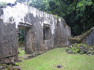
Moanalua is a valley, a stream, an ahupuaʻa, and a residential neighborhood in Honolulu, Hawaiʻi. The valley extends inland from behind Āliapaʻakai crater (Salt Lake) to the crest of the Koʻolau Range.

Honolulu State capital city in Hawaii, United States

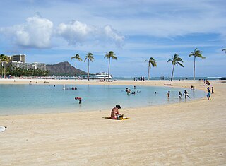
Honolulu is the capital and largest city of the U.S. state of Hawaiʻi. It is an unincorporated part of and the county seat of the City and County of Honolulu along the southeast coast of the island of Oʻahu. The city is the main gateway to Hawaiʻi and a major portal into the United States. The city is also a major hub for international business, military defense, as well as famously being host to a diverse variety of east-west and Pacific culture, cuisine, and traditions.

Hawaii State of the United States of America

Hawaii is the 50th and most recent state to have joined the United States, having received statehood on August 21, 1959. Hawaii is the only U.S. state located in Oceania, the only U.S. state located outside North America, and the only one composed entirely of islands. It is the northernmost island group in Polynesia, occupying most of an archipelago in the central Pacific Ocean.

Salt Lake, Hawaii Neighborhood of Honolulu, Hawaii, United States

Salt Lake is a neighborhood of Honolulu, Hawaii on the island of O‘ahu. The area is also known as Āliamanu after a nearby crater, although Salt Lake itself is in a crater called Ālia pa‘akai — meaning "salt pond" in the Hawaiian language. The Salt Lake community was developed in the 1960s during a construction boom, providing residents with an expansive view of downtown Honolulu and the sugarcane plantations of the central plain of O‘ahu. It is a community of high-rise condominiums, mid-rise town-dwellings, and houses snaking around the remnants of a now freshwater lake.

Contents

Neighboring areas include Māpunapuna and Salt Lake on the south, Fort Shafter on the east, and Red Hill and Hālawa Valley on the west.

Fort Shafter United States Army Pacific headquarters in Honolulu, Hawaii, USA

Fort Shafter is in Honolulu CDP, City and County of Honolulu, Hawai‘i, extending up the interfluve (ridgeline) between Kalihi and Moanalua valleys, as well as onto the coastal plain at Māpunapuna. Fort Shafter is the headquarters of the United States Army Pacific, commanding most Army forces in the Asia-Pacific region with the exception of Korea. A portion of the area is also known as the Palm Circle Historic District and is listed on the National Register of Historic Places, and has been further designated as a U.S. National Historic Landmark. It is also known as Palm Circle or 100 Area. Palm Circle covers an underground command center.

Halawa, Hawaii Census-designated place in Hawaii, United States

Halawa is a census-designated place (CDP) in the ‘Ewa District of Honolulu County, Hawaii, United States. Halawa Stream branches into two valleys: North and South Halawa; North Halawa is the larger stream and fluvial feature. Their confluence is within the H-3/H-201 highways exchange. Most of Halawa Valley is undeveloped. As of the 2010 Census, the CDP had a population of 14,014.

Moanalua is a part of the 15th District of the Hawaii Senate, currently represented by State Senator Glenn Wakai. It is also a part of the 32nd District of the Hawaii House of Representatives, currently represented by Linda Ichiyama.

Hawaii Senate Upper house of the Hawaii State Legislature

The Hawaii Senate is the upper house of the Hawaii State Legislature. It consists of twenty-five members elected from an equal number of constituent districts across the islands and is led by the President of the Senate, elected from the membership of the body, currently Ron Kouchi. The forerunner of the HawaiiSenate during the government of the Kingdom of Hawaii was the House of Nobles originated in 1840. In 1894 the Constitution of the Republic of Hawaii renamed the upper house the present senate. Senators are elected to four-year terms and are not subject to term limits.

Hawaii House of Representatives Lower house of the Hawaii State Legislature

The Hawaii House of Representatives is the lower house of the Hawaii State Legislature. Pursuant to Article III, Section 3 of the Constitution of Hawaii, amended during the 1978 constitutional convention, the House of Representatives consists of 51 members representing an equal number of districts across the islands. It is led by the Speaker of the House elected from the membership of the House, with majority and minority leaders elected from their party's respective caucuses. The current Speaker of the House is Scott Saiki.

Linda Ichiyama American politician

Linda Ichiyama is a Democratic member of the Hawaii State House of Representatives, representing Moanalua, Aliamanu and Salt Lake, Hawaii in the 32nd District since 2013. Prior to this, Representative Ichiyama represented the same area when it was known as the 31st District since 2010.

Location

The Moanalua neighborhood includes a portion that extends up Ala Aolani Street into the valley 21°22′0″N157°53′36″W / 21.36667°N 157.89333°W / 21.36667; -157.89333 Coordinates: 21°22′0″N157°53′36″W / 21.36667°N 157.89333°W / 21.36667; -157.89333 , and another part that extends eastward along the lower slopes of the interfluve (slopes between valleys) to Fort Shafter and into the small valley of Manaiki Stream. The latter part includes Tripler Army Medical Center above the neighborhood and Moanalua Gardens below it.

Geographic coordinate system Coordinate system

A geographic coordinate system is a coordinate system that enables every location on Earth to be specified by a set of numbers, letters or symbols. The coordinates are often chosen such that one of the numbers represents a vertical position and two or three of the numbers represent a horizontal position; alternatively, a geographic position may be expressed in a combined three-dimensional Cartesian vector. A common choice of coordinates is latitude, longitude and elevation. To specify a location on a plane requires a map projection.

Tripler Army Medical Center hospital

Tripler Army Medical Center is the headquarters of the Pacific Regional Medical Command of the armed forces administered by the United States Army in the state of Hawaii. It is the largest military hospital in the Asian and Pacific Rim region and serves a military sphere of jurisdiction that spans over 52% of the Earth's surface. Located on the slopes of Moanalua Ridge overlooking the Honolulu neighborhoods of Moanalua and Salt Lake, Tripler Army Medical Center's massive coral pink structure can be seen from any point in the Honolulu District.

Moanalua Gardens

Moanalua Gardens is a 24-acre (97,000 m2) privately owned public park in Honolulu, Hawaii. The park is the site of the Kamehameha V Cottage which used to be the home of Prince Lot Kapuāiwa, who would later become King Kamehameha V. It is also the site of the annual Prince Lot Hula Festival, and the home of a large monkeypod tree that is known in Japan as the Hitachi tree.

History

Samuel Mills Damon inherited the ahupuaʻa (uplands-to-sea tract) of Moanalua in 1884 from Ke Aliʻi, Bernice Pauahi Bishop, whose husband Charles Reed Bishop was a business partner of Damon. Before her, since the lands were won in battle by Kamehameha I they passed from a number of figures, then to Prince Lot Kapuāiwa (who became King Kamehameha V), and then to Princess Ruth Keʻelikōlani after Kamehameha V's passing. [1]

Samuel Mills Damon businessman and politician in the Kingdom, Republic, and Territory of Hawaii

Samuel Mills Damon was a businessman and politician in the Kingdom of Hawaii, through the Republic of Hawaii and into the Territory of Hawaii.

Ahupuaa

Ahupuaʻa is a Hawaiian term for a large traditional socioeconomic, geologic, and climatic subdivision of land.

Bernice Pauahi Bishop Hawaiian princess and philanthropist

Princess Bernice Pauahi Bishop, born Bernice Pauahi Pākī, was an aliʻi (noble) of the Royal Family of the Kingdom of Hawaii and a well known philanthropist. At her death, her estate was the largest private landownership in the Hawaiian Islands, comprising approximately 9% of Hawaii's total area. The revenues from these lands are used to operate the Kamehameha Schools, which were established in 1887 according to Pauahi's will. Pauahi was married to businessman and philanthropist Charles Reed Bishop.

Damon later became one of the first trustees of the Kamehameha Schools established by the Bishops. The Damon estate sold much of Moanalua to commercial and residential developers in 1956. Moanalua Elementary School was established in the area in 1884.[ citation needed ]

Kamehameha Schools private school system in Hawaiʻi

Kamehameha Schools, formerly called Kamehameha Schools Bishop Estate (KSBE), is a private school system in Hawaiʻi established by the Bernice Pauahi Bishop Estate, under the terms of the will of Bernice Pauahi Bishop, who was a formal member of the House of Kamehameha. Bishop's will established a trust called the "Bernice Pauahi Bishop Estate" that is Hawaiʻi's largest private landowner. Originally established in 1887 as an all-boys school for native Hawaiian children, it shared its grounds with the Bishop Museum. After it moved to another location, the museum took over two school halls. Kamehameha Schools opened its girls' school in 1894. It became coeducational in 1965. The 600-acre (2.4 km2) Kapālama campus opened in 1931, while the Maui and Hawaiʻi campuses opened in 1996 and 2001, respectively.

Moanalua Elementary School is a public school located in Moanalua, located in The City and County of Honolulu, Hawaiʻi. Moanalua Elementary is a highly acclaimed for its education system, and made the top 20 in Honolulu Magazine's top schools of Hawaii. It currently has above 1,000 students.

Wai'apuka

1. Kamana Nui - Moanalua Gardens (S. M. Damon Estate) The Western tributary of Moana-lua Valley, O'ahu. Lit., large Ka-mana

2. Kamana Iki - The eastern and smaller tributary of Moana-lua Valley, O'ahu. Lit., small Ka-mana.

3. Wai-puka - Pools near the mouth of Ka-mana Iki Valley, Moana-lua, O'ahu, where chiefs bathed after games and wrestling. Lit., issuing water.

Moanalua Gardens

One of many trees at Moanalua Gardens Moanalua park tree.jpg
One of many trees at Moanalua Gardens

Moanalua Gardens are inland from the Interstate H-201 which is known as the Moanalua Freeway, off Exit 3. One of its monkey pod trees is seen on Hitachi's Japanese TV commercials, and is occasionally referred to as Hitachi no ki( ja:日立の樹 , "Hitachi tree") in Japan. [2]

The gardens were a gift to the public from Damon and maintained by a trust since his death in 1924. It was one of Hawaiʻi's earliest public parks although has remained privately owned.

Related Research Articles

Interstate H-3 is an intrastate Interstate Highway located on the island of O'ahu in the state of Hawaii in the United States. H-3 is also known as the John A. Burns Freeway. It crosses the Ko'olau Range along a viaduct and through the 5,165-foot-long (1,574 m) Tetsuo Harano Tunnels as well as the much smaller Hospital Rock Tunnels.

Menehune legendary people of the Hawaiian Islands

Menehune are a mythological dwarf people in Hawaiian tradition who live in the deep forests and hidden valleys of the Hawaiian Islands, hidden and far away from human settlements.

Laie, Hawaii Census-designated place in Hawaii, United States

Laie is a census-designated place (CDP) located in the Koolauloa District on the island of Oahu in Honolulu County, Hawaii, United States. In Hawaiian, lāʻie means "ʻie leaf". The population was 6,138 at the 2010 census.

Waimānalo, Hawaii Census-designated place in Hawaii, United States

Waimānalo is a census-designated place (CDP) in the City & County of Honolulu, in the District of Koʻolaupoko on the island of Oʻahu, Hawaii, United States. This small windward community is located near the eastern end of the island. In the Hawaiian language Waimānalo means "potable water"; it is so named for the many brackish ponds in the area that were used for irrigation. As of the 2010 Census, the CDP had a population of 5,451.

Waipio, Hawaii Census-designated place in Hawaii, United States

Waipiʻo is a census-designated place (CDP) located in the Ewa District of the island of Oʻahu in the City & County of Honolulu, Hawaii, United States. In Hawaiian, wai piʻo means "curved water". As of the 2010 census, the CDP had a population of 11,674.

Moanalua High School is a public, co-educational college preparatory high school of the Hawaiʻi State Department of Education and serves grades nine through twelve. Established in 1972, Moanalua High School is located in suburban Salt Lake near Moanalua in the City & County of Honolulu of the state of Hawaiʻi. Its first class graduated in 1975. The school is situated on an extinct volcano hillside overlooking downtown Honolulu at 2825 Ala ʻIlima Street. The campus boasts the bronze sculpture Moanalua by Bumpei Akaji and the ceramic sculpture Silent Sounds by Shigeharu Yamada.

Mauna ʻAla

Mauna ʻAla in the Hawaiian language, is the Royal Mausoleum of Hawaii and the final resting place of Hawaii's two prominent royal families: the Kamehameha Dynasty and the Kalākaua Dynasty.

Manoa valley and a residential neighborhood of Honolulu, Hawaiʻi

Mānoa is a valley and a residential neighborhood of Honolulu, Hawaiʻi. The neighborhood is approximately three miles east and inland from downtown Honolulu and less than a mile from Ala Moana and Waikīkī at 21°18.87916′N157°48.4846′W.

Nuʻuanu Pali Section of the windward cliff of the Koʻolau mountain on Oʻahu, Hawaii

Nuʻuanu Pali is a section of the windward cliff of the Koʻolau mountain located at the head of Nuʻuanu Valley on the island of Oʻahu. It has a panoramic view of the windward (northeast) coast of Oʻahu. The Pali Highway connecting Kailua/Kāneʻohe with downtown Honolulu runs through the Nuʻuanu Pali Tunnels bored into the cliffside.

Kalihi Neighborhood in Honolulu, Hawaii, United States

Kalihi is a neighborhood of Honolulu on the island of Oʻahu in Hawaiʻi, United States. Split by the Likelike Highway, it is flanked by downtown Honolulu to the east and Mapunapuna, Moanalua and Salt Lake to the west.

Ahupuaa O Kahana State Park

Ahupuaʻa O Kahana State Park, formerly Kahana Valley State Park, is located on the windward side of Oʻahu between Kaʻaʻawa and Punaluʻu. The park is located mauka from Kahana Bay. It is Hawaii's only public ahupuaʻa, and it stretches from the sea to the tip of Puʻu Pauao at 2670 feet. It has a tropical climate, and it is one of the wettest areas in Oʻahu, averaging nearly 300 inches per year in parts of the valley. The main purpose of the park is to embrace and teach Hawaiian culture.

Waimea Valley botanical garden

Waimea Valley is an area of historic cultural significance on the North Shore of Oahu, Hawaii. The valley, being an important place in Hawaiian religion, includes several historical structures including stone terraces and walls constructed during the time of the Hawaiian monarchy. The nutrient-rich volcanic soil combined with a rainy environment provided the resourceful Hawaiians of the area the opportunity to create one of the most prosperous farming communities in all of Polynesia. The area had complex fish ponds, domesticated animal pens, various large farming beds, and was famous for the cultivation of pink taro root stock, a coveted item to the Ali`i. Much of the garden floor was once cultivated for taro, sweet potato, and bananas, with new crops and orchards introduced by Europeans after their arrival.

Kaniakapupu

Kaniakapūpū, known formerly as Luakaha, is the ruins of the former summer palace of King Kamehameha III and Queen Kalama on the island of Oahu in Hawaii. Built in the 1840s, and situated in the cool uplands of the Nuʻuanu Valley, it served as the king and queen's summer retreat after the capital of the Kingdom of Hawaii moved from Lahaina to Honolulu in 1845. It was famous for being the site of a grand luau attended by an estimated ten thousand guests during the 1847 Hawaiian Sovereignty Restoration Day celebration. The palace had fallen into ruins by 1874; no records exist about its condition in the intervening years. Rediscovered in the 1950s, the site was cleared and efforts were made to stabilize the ruins from further damage by the elements and invasive plant growth. The site remains officially off-limits to the public and trespassers are subjected to citations, although the site is not regularly monitored.

Kapālama, now often called Pālama, is a neighborhood of Honolulu, Hawaii. It is often combined with the adjacent Kalihi and referred to as a single entity, Kalihi–Pālama.

Duke Paoa Kahanamoku Lagoon Man-made wading pool in Waikiki, Honolulu, United States

Duke Paoa Kahanamoku Lagoon is a small, man-made wading pool in the Waikiki neighborhood of Honolulu, on the south shore of the island of Oʻahu near the Ala Wai Small Boat Harbor and Fort DeRussy Military Reservation. The Hilton Hawaiian Village is adjacent to the lagoon.

Golf clubs and courses in Hawaii

There are 75 golf courses in Hawaii.

Ke AliʻiKilinahe was a kaukau aliʻi noble who served under the ruling ali'i nui of the islands of Hawaii, Maui and Oahu, during the Kingdom of Hawaii. He is of the House of Moana and a collateral family of the House of Kamehameha. He performed his hana lawelawe or "service task" under Ka'ahumanu and Kamehameha III, starting as a kāhili bearer and royal attendant. He was brought into the Royal Court by Charles Kanaina to assume all of his duties and responsibilities. He toured Oahu with the Royal Circuit and managed the chief's goods. Kilinahe, in the Hawaiian language, means "light rain".

References

  1. Mary Kawena Pukui; Samuel H. Elbert; Esther T. Mookini (1 January 1974). Place Names of Hawaii. University of Hawaii Press. pp. 152–. ISBN   978-0-8248-0524-1.
  2. "The Hitachi Tree on-line". web site. Hitachi, Ltd. Retrieved August 9, 2010.